 Slashdot Mirror
New MH370 Analysis Again Suggests Plane Came Down Outside Search Area (theregister.co.uk)
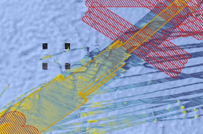
An anonymous reader shares a report: New analysis of images thought to depict wreckage from missing Malaysian Airlines flight MH 370 suggest the Boeing 777 came down to the north of the area searched during efforts to find the plane. A new document [PDF] released yesterday by Geoscience Australia (GA) detailed analysis of four images captured by the PLEIADES 1A Earth-imaging satellite on March 23rd, 2014, not long after the March 8th disappearance of the plane. The images were provided to GA by the French Ministry of Defence. The images depict an area to the north and east of the area searched by underwater survey, and in-between areas where search and rescue operations were conducted in the wake of the plane's disappearance. The image displays the areas covered by underwater survey in yellow and the search and rescue zones in red. Extensive manual analysis of the images -- there was not enough data to use machine learning -- yielded a dozen objects that researchers were happy to classify as "probably not natural." Several of those objects were clustered in the northern parts of the areas depicted in the photos. The document is at pains to point out that it is not possible to identify the objects as airplane debris. The new analysis referred back to drift pattern analysis made on debris known to have come from MH370 and released in December 2016. That analysis suggested the search area be extended by 25,000km2. More detailed drift analysis released in April 2017 also called for a new search to the north, as did a July talk by scientists from Australia's Commonwealth Scientific and Industrial Research Organisation.
And a backup to that could be to gradually leak micro-beads with a distinct chemical signature that would float to the top to leave a trail. That way if the broadcasting electronics are damaged, there is a secondary way to find sunken planes.
Modern black boxes are already designed to emit an ultrasonic pulse that can be picked up via acoustic locating equipment. It starts once the black box hits the water, occurs once per second for the next 30-40 days, and should be able to be picked up from 2000-3000m away under typical conditions, or even further if the conditions are good. Even so, most regulatory agencies are already bumping the battery life up, just because 30 days was viewed as too few after MH370.
Really, when you get down to it, our society's record for locating black boxes is remarkably good. Since the 1960s when they were introduced, we've had thousands of crashes, many of which would have involved recovering the black box, yet we've only failed to do so—or took a long time to do so—in a few dozen of those cases (here's an incomplete list). As such, there hasn't been much pressure to rely on a satellite uplink or similar system, given that they're significantly more expensive to produce, much more complex (more parts that can fail), and most of them would require ongoing support and maintenance costs (e.g. something on the ground that collects the data).
Even so, the UN's regulatory agency that covers this stuff (the ICAO) has already mandated that by 2020, all new planes are required to have some method to ensure that the black box data is recoverable in case of a crash, whether by ejecting the box before the crash (like military craft) or through continuous transmission to the ground over the course of the flight, so these sorts of issues will hopefully be things of the past in a few more years.