Slashdot Mirror
Domain: geonames.org
Stories and comments across the archive that link to geonames.org.
Comments · 8
-
geonames.org
I dont know if this will help you or not, but http://www.geonames.org/ data is under the Creative Commons and provides webservices that you could write your own apps to take advantage of. From what I understand, you can add points to the database (if they dont already exist).
-
Re:So counterproductive
Also this: http://www.geonames.org/
-
Re:cold fusion fraud again?
Ok, now you are just being a goddamn moron.
What the matter, your portugese rejects all butt-hurt over the nerds explaining how brazilan papers are going to get fucked in the ass for picking a fight with Google news in the other thread? You gotta come pollute other threads too?
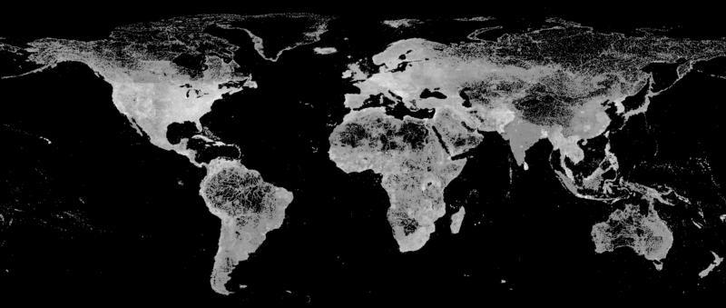
Take a look at this map: http://www.geonames.org/img/800px-GeonamesDensity.png
Population density of brazil is all packed up against the coast. Of course you have a good grid, in your geography it's easy.
Your assertion of "covering the population" is just stupid. If even half the US has electricity, the grid in the US is both bigger, and better than the grid in brazil. And, you fucking morons are spending a lot of money lighting up what is essentially jungle-wasteland in the central Amazon basin for four or five guys living in a hut somewhere? LOL. That's absolutely ridiculous. In the US, people who are off the grid are often surrounded by neighbors who are on the grid. It's a choice, and not influenced by some third-world shithole idiot's idea of a good penis measuring contest.
-
Re:Check In from Mars
In that case it's time to pay up!
-
Re:Bye Apple
They could have purchased TomTom, for example and had everything up and running immediately.
I think it's a bit more complicated than that. From Apple's mapping attribution page:
© 2006-2012 TomTom
Business listings data © Acxiom, 2012.
Map data © AND.
Property parcel data for USA. © CoreLogic Inc., 2012.
Satellite imagery data © DigitalGlobe, 2012.
Map and postal data © DMTI, 2012. This software contains Postal Code OM Data copied by Apple under a sub-license from DMTI Spatial Inc., a party directly licensed by Canada Post Corporation. The Canada Post Corporation file from which this data was copied is dated 2012.
Business listings data © Factual 2012.
Map data © Getchee, 2012.
© INCREMENT P CORP., 2012, http://www.incrementp.co.jp/gc01info/e/legal01.html.
Map data © Intermap, 2012.
Map data © LeadDog, 2012.
Business listings data © Localeze, 2012.
Mapping data for Australia and New Zealand. © MapData Services Pty Ltd., 2012, PSMA http://www.nowwhere.com.au/lic/NowWhereLic.htm.
Map data © MDA Information Systems, Inc., 2012.
Neighborhood data © Urban Mapping, 2012.
Map data © 2012 Waze.
âoeReviews from Yelpâ Yelp, 2012.
(CanVec)
© Department of Natural Resources Canada. All rights reserved.
http://www.geogratis.gc.ca/geogratis/en/index.html
(CGIAR-CSI SRTM)
CGIAR Consortium for Spatial Information, http://srtm.csi.cgiar.org/
Flickr Shapefiles Public Dataset, Version 1.0, http://www.flickr.com/
(GeoNames)
GeoNames and contributors, http://www.geonames.org.
(GlobCover)
© ESA 2010 and UCLouvain, http://www.esa.int/esaEO/index.html
National Aeronautics and Space Administration, http://www.nasa.gov
Contains Ordnance Survey data © Crown copyright and database right 2012. Contains Royal Mail data © Royal Mail copyright and database right 2012. http://www.ordnancesurvey.co.uk/oswebsite/
(OSDM)
© Commonwealth of Australia, 2012. This data has been used with the permission of the Commonwealth. The Commonwealth has not evaluated the data as altered and incorporated within this software, and therefore gives no warranty regarding its accuracy, completeness, currency or suitability for any particular purpose. http://spatial.gov.au
(OSM)
OpenStreetMap contributors, http://www.openstreetmap.org/
(StatCan)
Statistics Canada, http://www.statcan.gc.ca
(TIGER/Line® fi -
More geo?
-
ummm already...
ok I actualy really like yahoo maps...
google maps look pretty but they are not that fast compared to yahoo flash (.flv) maps for certain things
and frankly their fire eagle stuff blows the socks off the rest
BUT this feels much like the http://www.geonames.org/ and frabkly I prefer to use geonames I would have thought it would be much better that yahoo actually did something like this allowed people to download the data and provided a web service...
I prefer geonames because its open and well frankly works
it might be solving a differant problem but really this article does not point that out to me
regards
John Jones
http://www.johnjones.me.uk -
Not quite what you need
However, the site GeoNames has a *huge* world database of features with coordinates. I've used it for a few weird searches for a personal project. It's released under the creative commons attributions license. It's a bit raw for what you need, but I'm sure a dedicated group of folks could groom it to the purpose you require.