Slashdot Mirror
Domain: vedur.is
Stories and comments across the archive that link to vedur.is.
Comments · 11
-
Re:Some how 'preparing' doesn't seem like the righ
And she tends to have explosive eruptions.
So, a more derived (higher silica/ more viscous) magma, most likely. Implying a larger upper-crustal (5-15km depth) magma chamber for differentiation than for the other volcanoes. Interesting.
I'll keep on watching the earthquake reports. And I'll try to get the ö in jökullhlaup right more often until you get your thorn and I can type ÐÐÐÐ (Cyrillic, like
-
Re:If it was that easy and worked that well
No, it means that it was a pilot project and it's the first time they've tried this.
It's great news. I've been following as they've been working on this project. Most people wouldn't think we'd have much carbon dioxide here since virtually all of our power is either hydroelectric or geothermal, but we're actually abnormally high emitters per capita. Now, most of that's not easy to capture - we can pretty much rule out the fishing fleet, and two of the three aluminum smelters aren't that close to a geothermal plant (although I don't know if their technique needs to be directly coordinated with a geothermal plant or not). However, geothermal wells also can have surprising levels of CO2 emissions. They're quite varied, and generally far less than burning fossil fuels for power, but some of the worst wells can actually get up to a good fraction of the emissions of of an equivalent amount of fossil fuel power. So this experiment was conducted at Hellisheiði, which is the biggest geothermal plant in Iceland (and one of the biggest in the world), with the goal of making it eventually fully close-cycle. Maybe they'll also reduce their H2S emissions at the same time.
Concerning one thing in the article:
But Dr Matter said there was a risk of mobilising trace metals, potentially polluting downstream waterways. And any injection of water or CO2 into deep subsurface reservoirs carried the danger of “micro” earthquakes.
They're already making regular earthquakes on the production end, so what's the big difference? More to the point, who would even notice? Wow, gee, earthquakes in Iceland, we've never gotten those before
I also don't have much concerns about trace metals flowing into waters. Those are geothermal layers. Any waters there are geothermal waters. Which means that they're pretty "contaminated" to begin with. You don't drink geothermal waters, or anything that they flow into. I have a lot more concerns about 1) agricultural / livestock / septic system contamination, and 2) suspended particulate (aka surface water contamination). See Mývatn for the effects of both, Lagarfljót particularly for the latter. Our main areas of concern with bodies of water have generally been with either clouding them or causing algal blooms.
Then again, though, why should we even bother helping reduce CO2 levels? Make Iceland Covered With Redwoods Again!
-
Re:OMG
Yeah, it's morbidly fascinating to keep up with what's going on underground there. Whenever you run out of superlatives for how extreme the situation underground is, whatever crazy thing you were looking at before increases by half an order of magnitude
-
Re:OMG
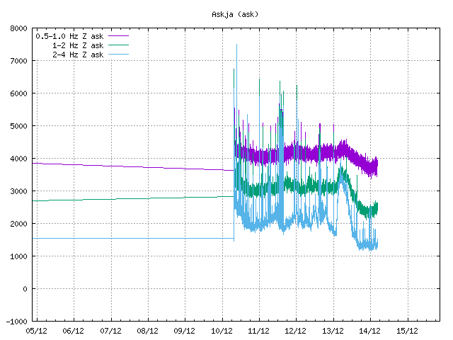
This has very little to do with Eyjafjallajökull. They called the red alert when the harmonic tremor that was being measured reached levels that in all previous cases (like Eyja in 2010 and Grimsvötn in 2011) indicated an eruption in progress, namely, large amount of magma moving through rock. This usually only happens when there is magma moving out of the ground somewhere aka an eruption in progress.
The big problem is, there was no such thing. Yet tremor hasn't died down at all. (This is from a recording station on Askja, which is a volcano a bit further away from the current action, but shows it just fine.)
There is a lot of magma on the move in the ground and by now there is very little reason left to believe it's just going to stay in the ground. Because it's just too darn much. An eruption on saturday would have been preferable to what we are seeing now.
-
YouTube
Why is it that when a thing like this happens (supposedly), we're directed to the misguided BBC, and to cowardous CNN? Doesn't Iceland have some kind of geologic society or meteorlogic society that issues reports based on adequate, current, hot-off-the-volcano scientific data?
The icelandic met office has a site that tracks seismic activity (read: earthquakes), they have an english website: http://en.vedur.is/#tab=skjalf... The University of Iceland's institute of earth sciences has a news page in english: http://earthice.hi.is/bardarbu... They have also set up a number of webcams: http://www.livefromiceland.is/... (Vaðalda, north of Vatnajökull, towards Bárðabunga) http://vedur2.mogt.is/grimsfja... (Grímsfjall) http://vedur2.mogt.is/kverkfjo... (Kverkfjöll) Not very spectacular sites but the content is a bit better than most of the bullshit you are likely to get from the corporate media.
There is now also a YouTube channel: https://www.youtube.com/watch?...
-
Re:How is it
Why is it that when a thing like this happens (supposedly), we're directed to the misguided BBC, and to cowardous CNN? Doesn't Iceland have some kind of geologic society or meteorlogic society that issues reports based on adequate, current, hot-off-the-volcano scientific data?
The icelandic met office has a site that tracks seismic activity (read: earthquakes), they have an english website: http://en.vedur.is/#tab=skjalf...
The University of Iceland's institute of earth sciences has a news page in english: http://earthice.hi.is/bardarbu...
They have also set up a number of webcams:
http://www.livefromiceland.is/... (Vaðalda, north of Vatnajökull, towards Bárðabunga)
http://vedur2.mogt.is/grimsfja... (Grímsfjall)
http://vedur2.mogt.is/kverkfjo... (Kverkfjöll)
Not very spectacular sites but the content is a bit better than most of the bullshit you are likely to get from the corporate media. -
Re:How big is this thing?
There's a map of Bardarbunga's earthquakes over the last week here. These are mostly magnitude 2 - 3, but there are dozens of them.
-
Re:Streams from the volcano and more
Written from the inside the ash cloud, Reykjavik For those of you who are interested there are a few streams online of the volcano and surroundings. These are being set up so they are not all functional at this moment. Also dont expect to see much in all the webcams when the wind is blowing from certain directions. The ash cloud actually reached Reykjavík 26 hours after the start of the eruption, which is much fast than last summer during the eruption in Eyjafjöll. I will have to give you a few pointers in icelandic since the english version does not have a direct link to the webcams. Webpage: http://live.mila.is/ "Vefmyndavélar" means webcams so click that link. Currently the bottom three streams are of the volcanoe. "Grímsvötn" is the volcanic system "Hvannadalshnjúkur" is the mountain not far from Grímsvötn. And finally a little extra treat, a time vs richter map of the eartquakes in the area Again "Vatnajökull" is the glacier that Grímsvötn are in so you can click that for a more detailed map. Have fun.
Sorry, forgot the link to the earthquake site http://en.vedur.is/earthquakes-and-volcanism/earthquakes/
-
Re:Its going to get much worse...
There's no evidence in that article other than historical patterns. As far as I've been able to determine from numerous sources, there is no sign of increased earthquake activity or inflation of the mountain at Katla yet (due to injection of magma at depth beneath it), and those processes will precede any significant eruption there just as it did at Eyjafjallajokull. It will not be a surprise. There's an extensive seismometer, GPS, and tiltmeter network around both these mountains (Eyjafjallajokull and Katla), so there will be at least a couple of days notice if Katla starts to stir. Look, here's a report from a few weeks before the Eyjafjallajokull eruption started (back in March). It's badly translated by Google Translate, but look at the clump of earthquakes around Eyjafjallajokull in the map (the peak on the left). Katla is the glacier covered peak on the right (labeled Myrdalsjokull -- the volcanic caldera of Katla is the circle with tick marks) -- not much going on back then. Back in March it was hard to tell if this earthquake spike was a sign an eruption was actually about to occur (sometimes you get magma moving around but never making it to the surface), but a similar spike in earthquakes beneath Katla will almost certainly occur there beforehand, and if it occurs you can be 100% sure that it will show up in the news, because people will start being evacuated from around that peak too. If you look at Iceland earthquake maps for the last week, or this one for the last 48 hours using Google Earth (you can also download a KML file), you can see most of them continue to be under Eyjafjallajokull and not under Katla.
So, yes, genuine cause for concern because of historical patterns and because Katla is a much larger and more explosive volcano historically (Ejafjallajokull's eruptions have a Volcanic Explosivity Index of 1, but Katla has had VEI up to 4, and it's a log scale), but nothing specific YET that suggests it is becoming active. Watch the news and we'll see.
-
Re:Its going to get much worse...
There's no evidence in that article other than historical patterns. As far as I've been able to determine from numerous sources, there is no sign of increased earthquake activity or inflation of the mountain at Katla yet (due to injection of magma at depth beneath it), and those processes will precede any significant eruption there just as it did at Eyjafjallajokull. It will not be a surprise. There's an extensive seismometer, GPS, and tiltmeter network around both these mountains (Eyjafjallajokull and Katla), so there will be at least a couple of days notice if Katla starts to stir. Look, here's a report from a few weeks before the Eyjafjallajokull eruption started (back in March). It's badly translated by Google Translate, but look at the clump of earthquakes around Eyjafjallajokull in the map (the peak on the left). Katla is the glacier covered peak on the right (labeled Myrdalsjokull -- the volcanic caldera of Katla is the circle with tick marks) -- not much going on back then. Back in March it was hard to tell if this earthquake spike was a sign an eruption was actually about to occur (sometimes you get magma moving around but never making it to the surface), but a similar spike in earthquakes beneath Katla will almost certainly occur there beforehand, and if it occurs you can be 100% sure that it will show up in the news, because people will start being evacuated from around that peak too. If you look at Iceland earthquake maps for the last week, or this one for the last 48 hours using Google Earth (you can also download a KML file), you can see most of them continue to be under Eyjafjallajokull and not under Katla.
So, yes, genuine cause for concern because of historical patterns and because Katla is a much larger and more explosive volcano historically (Ejafjallajokull's eruptions have a Volcanic Explosivity Index of 1, but Katla has had VEI up to 4, and it's a log scale), but nothing specific YET that suggests it is becoming active. Watch the news and we'll see.
-
Accessibility and usability can go hand in hand
Accessibility and usability can go hand in hand - an example and advices
The web site for the Icelandic Meteorological Office has achieved accessibility certification based on WAI (Web Accessibility Initiative). It has received very good critics for usability. It received an award for the best Icelandic Web-site in public service during 2007.
The most important weather forecasts and observations are shown graphically on maps but are still accessible for disabled people. This is achieved using Web2 techniques.
There are less than 400.000 people living in Iceland. The Icelandic Met. Office is small. It employs only a handful of tech guys running the whole operation. The Icelandic Met. office would be considered very small compared to any small or medium size office in USA and Europe
Still this micro met. office has a web site with good accessibility and usability. There is no excuse for USA companies not to do it too.
Here are some advices:
- - Before starting on the user interface design, get your self acquainted to accessibility issues in web design.
- - Work with a company that specializes in web accessibility from the start of the project.
- - Implement the accessibility from the start. Not afterwards.
- - Select a content management system that supports accessibility fairly well.
- - CSS design is a critical part for good accessibility. Preferably work with CSS designer that has experience CSS design for accessibility.
- - Have the design tried and tested with disabled people.
- - Don't give up on accessibility although you are squeezed for time