 Slashdot Mirror
Domain: worldwindcentral.com
Stories and comments across the archive that link to worldwindcentral.com.
Comments · 56
-
NASA World Wind Java Re:Google maps for trackingMight I suggest looking into the NASA Open Source application, World Wind? You can do anything you can think of.. and people have used it to track several thousand objects in real time and from a database.
You can see some of what can be done on the demos page.
What you want to do is fairly simple, and has been done before.. you can probably find enough code examples in the SDK and on the forum.
-
Better or worse than NASA World Wind?
NASA World Wind and its add-ons tend to use a single data set for each layer rather than a pastiche of the highest resolution imagery available like Google Earth's, so when I compared it to Mars in 5.0, it had a more cohesive view with a more navigable user interface, with no load time since you can download the entire cache as an add-on.
-
This was predicted three years ago
Though at the time.. it was just a April Fools joke..
-
Only two years behind World Wind now..
SDSS (Sloan Digital Sky Servey) has been in World Wind over a year now. And Stellarium is still the best way to properly look at the sky from a computer. You have no true reference points in the GE Sky.. it is just a "pretty viewer".
-
Re:PC only?Sorry, that should be "multithreaded device access". I was quoting from this entry linked from the FAQ: one small but critical element for the use of DirectX over OpenGL, multi-threaded graphics device access. Not sure exactly how DirectX (now Direct3D) implements its thread-safe layer, but I think the important question is how well will the new Java version work? I haven't played with Java3D much, but I doubt it's integrated with hardware as closely as DirectX is, so I can't imagine its performance is going to be comparable.
-
Virtual Earth high resolution imagery in NASA WW
Can't see high resolution imagery in NASA World Wind? Well, you can with this great plugin. It allows you to use Microsoft Virtual Earth high rez imagery directly in NASA World Wind. If you wonder, yes, Microsoft agreed to this.
-
NASA World Wind vs Google Earth
I'm a NWW enthusiast, even if I never really used it on a regular basis... (I'm waiting for the Java version... I hope I won't be deceived).
NASA World Wind sadly never had the media coverage GE had. This is kind of sad. People seems to forget, or ignore, that you can't use Google Earth in a work environment. Well, more precisely, you can't legally install the free version Google Earth in any work environment, not even the Plus version (20$US), you need the Pro (400$US) or the Enterprise version. Why am I underlining this? Because I believe this should have helped NASA World Wind to capture mind share. Should, because not a lot of people care about that fact and Google will not enforce this, since they benefit from the number of people using it, a little like Microsoft did not care about Windows being copied some centuries ago. Oh, this change in the license came with version 4 of the GE beta, launched last summer.
Here's the interesting Google Earth vs NASA World Wind comparison, on the WW Central website. -
Whoa -- useful for design ...
I noticed that the kinds of infographic abilities shown here: http://www.dynagis.net/gallery_screenshots/ are now free, as the plugin that provides them is now CC licensed. (more info here: http://www.worldwindcentral.com/wiki/Add-on:DYNAG
I S_Golden_Pearl)
THAT is pretty cool, actually. As someone often called on to do design tasks that straddle the line between infographic and visualization, I think I need to give WW another look. I never really considered it once Google Earth came out, because Google Earth was easier for whatever globehopping question I had. But being able to quickly do this kind of visualization ("uh, hey -- we need a picture of the population density of South Dakota, matching our company's color scheme, by tomorrow") should make my life a little easier. -
Re:Oh ya
Actually, most of the imagery used by Google Earth is satellite images from Landsat, topography from SRTM, and aerial images from USGS - all viewable in 3-D using NASA's educational WorldWind program.
Program: http://worldwind.arc.nasa.gov/
Community: http://www.worldwindcentral.com/
WorldWind was available before Google Earth was born, but it was not marketed into news headlines. WorldWind does not limit your local cache size the way Google Earth does, so you can download the whole multi-terabyte Landsat and SRTM datasets if you are so inclined. It is also extendable by user add-ons, of which many exist. WorldWind links to cartographic and placename databases, and also provided alternate planets before Google Earth, and now includes the Moon, Mars, Venus, and Jupiter (via NASA mission data), as well as the night sky (via SDSS imagery).
Google Earth adds commercial non-US aerial images to the freely-available data used by WorldWind, and links to various commercial directories and maps, but is otherwise a follower of WorldWind rather than a leader. -
Why Wait? World Wind has SDSS NOWWhy wait for this when the Sloan Digital Sky Survey http://www.worldwindcentral.com/wiki/Sdss is available in NASA World Wind
I just worry that with Google "helping" the imagery could be locked up so not everyone has free and equal access to the data.
-
Re:NASA WorldWind also ready for Linux and MacOSX
There was quite a bit of discussion in the mailing list in May (archives), especially the question you asked and the reply, and interest in doing it outside of SOC.
-
Re:NASA WorldWind also ready for Linux and MacOSX
There was quite a bit of discussion in the mailing list in May (archives), especially the question you asked and the reply, and interest in doing it outside of SOC.
-
Re:NASA WorldWind also ready for Linux and MacOSX
There was quite a bit of discussion in the mailing list in May (archives), especially the question you asked and the reply, and interest in doing it outside of SOC.
-
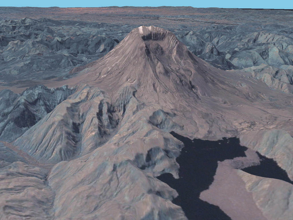
Re:NASA WorldWind also ready for Linux and MacOSX
For anyone wanting a quick eye-candy comparison, by a useful stroke of luck they both have 3D pics of Mount St. Helens as showcases on their respective web pages.
Google:
http://earth.google.com/images/mtsth.jpg
Worldwind:
http://www.worldwindcentral.com/wiki/images/b/b6/S rtm.jpg -
Re:NASA WorldWind also ready for Linux and MacOSX
There is also a World WInd clone written by Pat Murris - WW2D Plus One (homepage) written in Java.
It's obviously quite simplistic however it is a 3D world viewer and can use the same imagery as World Wind, so it's a start and certainly something to use if you want to see the good-looking Next Generation Blue Marble imagery for one thing
-
NASA WorldWind also ready for Linux and MacOSX
IF you go to this WindWindCentral page, you'll learn that Google Earth's open source competitor is readying Linux and Mac versions of NASA World Wind. You can learn a lot about WW here and a lot about GE here.
"NASA is currently making plans for World Wind 1.5. This version will be available for multiple platforms, including Windows, Linux and the Macintosh." -
Free Earth Foundation/3D globe NASA World Wind
The Free Earth Foundation, mainly working on NASA World Wind, is also participating. This 3D globe is somewhat similar to GE, but is very extensible and more science/classroom oriented than just looking at your house, and has a large community backing it.
-
The Free Earth Foundation is taking part, too
Everyone moans that NASA's World Wind doesn't do this, doesn't do that, and so on - well, we're a non-profit organisation centred around World Wind and we're taking part to hopefully produce lots of useful features for World Wind. More info, ideas and contact details are at our SoC page. See you there, or in #worldwind on Freenode
-
WorlWind and other links
The article discusses NASA WorldWind but several interesting links are missing. Amongst them: Punt, a WW fork. Heck, you can also see Microsoft Virtual Earth data in NASA WorldWind itself. Even Mars 3D in WW. (I stop here, if this interests you, read slashgeo.org
I don't know if Stellarium counts as "software for space exploration", but it's worthed. Celestia too. -
Re:profit!
World Wind already has Venus, no elevation data yet though, http://www.worldwindcentral.com/wiki/Add-on:Venus
-
Re:Or Mars in /3D/ With World Wind
Hell World Wind has had Mars for over a year, funny how when google does something it always makes
- _Offline_version_(for_World_Wind_1.3) -
NASA World Wind
http://worldwindcentral.com/ is more likely to have scientific data sets than Google Earth.
-
Re:Good article
Firstly - I don't actually work for NASA, but this should be fairly accurate info...
The next major revision *should* be also done in Java meaning some nice cross-platform capability. Sun is pretty interested in the whole thing last I heard. Should be out some time this year, I really don't have a clue when.
There is a forum section for ports: http://forum.worldwind.arc.nasa.gov/index.php?show forum=27
And someone has created a 2D WW clone in Java which runs on Linux, but apart from that, it's all talk and no walk the talk...understandable really since it's not exactly a thing for anyone but someone in a full-time team to be able to do.
Problem is NASA just hasn't had the budget to fund extra developers to do a cross-platform rewrite which is why there isn't one yet, and is also why they switched from OpenGL to C# & MDX back in ~summer 04 - to get something out before the funding was cut.
It's not a lack of will or interest, our goal as a community is to get free imagery out there and get it used, to make these tools available to all to hack away for their own needs, and so on. Home, schools, military....you name it.
World Wind is open source and frankly without us ~20 - 30 'core' volunteers (~10 of us originate from when WW was slashdotted in Sep 04, including me) it wouldn't be anywhere close to what it is today. But switching to a cross-platform method or any one person / small group coding their own just hasn't been do-able.
If there was one thing I'd say it would be 'support NASA' because they've done some great things with World Wind and they've listened to us, the community (most of the time
If anyone wants to drop by and contribute, please do, it's all good fun and freeee to be hacked away at. http://www.worldwindcentral.com/ and http://forum.worldwind.arc.nasa.gov/ - see ya there -
I can't take it any more!
Argh!
What the fuck does leveraged mean!?
I was under the impression that it involves a lever and a pivot point.
Yes, I know it's a buzzword, but this one is getting fucking ridicilous!
Dictionary.com has nothing to correlate leverage and utility. Link.
Next time advertisers and marketers decide to play buzzword bingo I hope they pick "Selma Hayek" as the buzzword of the month.
Most of the exploits that leveraged IE vulnerabilities to plant spyware were based on ActiveX and JavaScript, said Gribb.
parent: http://news.yahoo.com/s/cmp/20060210/tc_cmp/179102 616
World Wind leverages satellite imagery and elevation data to allow users to experience Earth terrain in visually rich 3D, just as if they were really there.
http://www.worldwindcentral.com/wiki/World_Wind
learn how other organizations leverage the pod
https://forums.omnipod.com/
And of course, to stay on topic, I'll save us all the trouble:
Firefox Users Surf Safer
No shit Sherlock?
or
It took two professors and two grad assistents to come to this conclusion? Money well spent Washington, money well spent. -
NASA World Wind plug-in
This plug-in shows the mess up there quite clearly, and it's only showing a fraction of whats really above our heads
-
Interesting outliers
I'm always fascinated by tiny inconsistencies. For instance, in this picture of the dark side of the moon, there are a few areas that haven't been photographed. The areas are in relatively consistent patterns, where the sattelite's camera may have malfunctioned or the orbit didn't cover certain areas. All except for one. Check out the top right, on the left side of a large crater. It's an outlier, all by itself, smack in the middle of an interesting formation. Wouldn't they have tried to get that spot again, on a second go around? Why is it missing? And why isn't it part of a patern like the others?
-
Re:View the moon in 3D with your EYES!!!
You can't "look up" to see the dark (far) side of the moon very well. Interestingly, you can't use this software to view certain areas of imagery that are conveniently missing from their data also. Notice especialy the left side of this shot with the strange pattern. http://www.worldwindcentral.com/hotspots/view_hot
s pot.php?id=1642&mode=full And as already mentioned, in the upper right, they don't have the core of the big, obvious impact crater? Somehow I don't think so! -
Re:Linux and Mac Versions
Quite correct. The thing with World Wind is that it's community-driven, so if people want ports then they need to step up and join in. In addition to your links there's also a forum section for ports and a how to get involved page on the Wiki. We welcome all the help we can get - I came to WW from the Slashdotting 12 months ago, so let's see what this time can bring
-
Developers are forking code to use java and c#!
According to the developer they are planning to create a Java version for linux as well as the C#/DirectX version they have now:
http://mail.worldwindcentral.com/pipermail/worldwi nd-dev/2005-September/000736.html
This is nuts! Trying to make one big complicated from work is hard enough, making two versions of it written in different languages is inexplicable! The only real reason hinted at is that Microsoft wouldn't like NASA using Mono for an official application. Does Microsoft really want NASA to use Java just to spite Mono?
Download the code for WorldWind and have a look, then consider porting it to Java/OpenGL/Java3D. Then consider just using Mono with OpenGL bindings. Or consider funding Wine so it supports
Somebody talk some sense into them. Or tell me why I'm wrong, either way someone has to sort this out otherwise it's going to be a massive waste of time and money.
I'm ranting, I know - can anyone else see how backward this is? -
Linux and Mac Versions
-
Linux and Mac Versions
-
my bad
Sorry I missed these earlier --
- A WorldWind BMNG app can be found here
- A GoogleEarth app can be found here.
Thanks to WorldWindCentral -- good job, neat stuff.
-
my bad
Sorry I missed these earlier --
- A WorldWind BMNG app can be found here
- A GoogleEarth app can be found here.
Thanks to WorldWindCentral -- good job, neat stuff.
-
my bad
Sorry I missed these earlier --
- A WorldWind BMNG app can be found here
- A GoogleEarth app can be found here.
Thanks to WorldWindCentral -- good job, neat stuff.
-
KMZ for boring people using boring app ;)
-
Re:put that in google maps:-D
Get the plugin for Nasa Worldwind http://worldwind.arc.nasa.gov/.
It was just released at WorldWind Central http://worldwindcentral.com/ today!
This is an application that will download the images as you want them, and you can fly around, zoom in from outer space and back out again - all kinds of stuff.
WorldWind is an open source program developed by NASA and the community. -
Re:NASA World Wind
Wow- that was FAST!
Looks like you guys beat Google Earth on another one!
This is really nice imagery-
Just in time for the upcoming WorldWind 1.3.3 http://worldwind.arc.nasa.gov/ release, eh?
Great work- you guys at http://www.worldwindcentral.com/ are amazing . . . -
Blue Marble NG in World Wind
Get the addon here. It is only 160KB as all data is downloaded on demand.
-
Re:NASA World Wind
All right, Nowak at World Wind Central has mirrored and created an add-on for NASA's World Wind. You can now easily view the entire next generation blue marble sets on any windows machine.
Please consider donating so we can continue to provide quality services like this.
To use simply download the client and the add-on. -
Video cards
This is the best reason yet to get a faster computer with a nice video card. It would be nice if someone had a wiki for linux people to mention their experiences. Seems many cards get glitches in zooming. See WorldWind video card page (for windows but maybe same issues on other linux software when zooming this data?) Speaking of which if anyone has a recommendation for a distro / windowmanager / xserver / video card / machine configuration for this type of thing now would be a good time! I remember when SGI used to sell a souped up PC for large dataset visualization (not that it sold I think..). My guess would be a motherboard with huge internal bandwidth and I/O, some big SATA drives, a couple gigs of RAM, and the latest video card by (who?)..
-
Re:Getting tired of Google's Microsoft Only Policy
You might want to follow the NASA World Wind project. It does the same thing as Google Earth and is open source.
If I remember correctly there is a "2D" port to Linux, by which I mean you can only view directly towards the surface of the earth and can't tilt it to see land elevation.
http://worldwind.arc.nasa.gov/ - main site
http://www.worldwindcentral.com/ - "fan" site
http://sourceforge.net/projects/nasa-exp/ - sf site
http://ww2d.berlios.de/ - 2D port
Cheers,
Roger -
Google Earth this, google earth that..Bah!
People just keep overlooking the better, World Wind. Sure, no high res outside the US (yet) but how about almost realtime Radar and forcast data? (Press F5 to get latest image)
If the data is out there, it can be formatted and brought in. And now that NWS has this.. I shall be making an add-on for WW now.
-
World Wind has had a real moon for ages
World Wind (http://worldwind.arc.nasa.gov/) has had a moon add-on for a long time see - http://www.worldwindcentral.com/wiki/Moon they also have a simple Solar system add-on - http://www.worldwindcentral.com/wiki/The_Planets plus slightly off-topic they have a 3D glasses plugin (http://www.worldwindcentral.com/wiki/Anaglyph_3D
_ (plugin)) for the upcoming 1.3.2 release. -
World Wind has had a real moon for ages
World Wind (http://worldwind.arc.nasa.gov/) has had a moon add-on for a long time see - http://www.worldwindcentral.com/wiki/Moon they also have a simple Solar system add-on - http://www.worldwindcentral.com/wiki/The_Planets plus slightly off-topic they have a 3D glasses plugin (http://www.worldwindcentral.com/wiki/Anaglyph_3D
_ (plugin)) for the upcoming 1.3.2 release.