 Slashdot Mirror
Domain: noaa.gov
Stories and comments across the archive that link to noaa.gov.
Comments · 2,602
-
Re:NOAA: Past Decade Warmest on Record According t
What's your source on say there has been no temperature increase in the last 10 years?
Would you believe... NOAA?
Wikipedia's list of hottest years is penultimately sourced from the NOAA. 2001-2010 all make that list, with a maximum difference over this span of only 0.13 degrees Celsius (2005 / 2008 are listed as hottest and coolest, respectively). In order for this to be "increasing", your measuring equipment must have a error rate below 0.13 degree Celsius. A search on their page finds that the NOAA's official equipment manuals gives an optimum [minimum] error range of 0.166 degrees Celsius [listed as 0.3 degrees Fahrenheit]. I don't challenge their numbers, but their accuracy figures says the last decade has seen — within the accuracy of the measuring equipment — no change in average temperature.
-
Re:Models are always right!
About 12 years ago there was one extremely hot year, so in 2009 you could use the "10 years" argument and show a flat average line
OK, let's ignore any dates in the 20th century. Take a look at Wikipedia's list of hottest years (penultimately sourced from the US NOAA). The maximum difference over this single decade is only 0.13 degrees Celsius (2008 / 2005).
In order for this to be reliable warming, you would have to measure with an error rate better than 0.13 degree Celsius. Given that the NOAA's official equipment guide gives in the specifications an optimum error range of 0.166 degrees Celsius [listed as 0.3 degrees Fahrenheit], I find it hard to believe any such argument at all. If your measured change is within the error range of your equipment, is it not more honest to grant this no statistical weight?
-
Re:Where's the beef?
Of course, since 1998 was the hottest year on record,
Try to keep up with the rest of us here. The data keeps coming in, you might want to include it in your deliberations.
It might even change your mind.
-
NOAA: Past Decade Warmest on Record According to S
source:
http://www.noaanews.noaa.gov/stories2010/20100728_stateoftheclimate.html
What's your source on say there has been no temperature increase in the last 10 years? -
Re:Models are always right!
-
Re:Where's the beef?From the article, which was written in July 2010:
Currently 1998 is the hottest year on record. Two combined land and sea surface temperature records from Nasa's Goddard Institute for Space Studies (GISS) and the US National Climatic Data Centre (NCDC) both calculate that the first six months of 2010 were the hottest on record. According to GISS, four of the six months also individually showed record highs.
At the time the article was written, the first six months of 2010 were hotter than the corresponding months in 1998. Unfortunately that trend continued, and this year NOAA announced that 2010 had tied with 2005 for the hottest year on record. (2005 was hotter than 1998; the guardian got that fact wrong).
Source: http://www.noaanews.noaa.gov/stories2011/20110112_globalstats.html -
Re:Geothermal issues
A hurricane has about 6e14 W. You might be able to create somewhere around 8kJ/day if you found a way to harness all your gas. That's about 1e-1 W. That's a difference of 15 orders of magnitude.
The earth has geothermal energy of about 1e31 J. 15 orders of magnitude less than that is 1e16J. That's less than what Zimbabwe uses annually. The core is radioactively replenished at 30TW. As of 2007 there was already 10GW of geothermal electric capacity. That's only 4 orders of magnitude. So no, it's not a fart in a hurricane. I am flabbergasted by these findings. I thought for sure you were right.
-
Electrification studies with radar
There was a rather large field campaign called The Severe Thunderstorm Electrification and Precipitation Study (STEPS) to study electrification done around the year 2000 that involved the use of polarimetric weather radar to observe electrified storms, in conjunction with the New Mexico Tech Lightning Monitoring Array (LMA).
One of the nice things about polarimetric radar is the ability to measure the aggregate orientation of particles, including ice crystals. When scanning active electrified storms, the radars observed polarimetric signatures indicating increased vertical orientation of particles aloft (ice crystals), which then suddenly snapped back to roughly random orientation. This event corresponded well with measurements from the LMA. In other words, they could, using radar, predict lightning strikes. I love science!
-
Re:Did it "confirm" it was caused by man?
It was not CRU's data. The CRU is not running monitoring stations, or even collecting data. The data was from the World Meteorological Organization, via the UK Met Office. Neither the CRU or the Met Office magically have permission to give away that data. In fact, CRU didn't even have that data anymore.
But, nevertheless, after all this happened, the Met Office went and asked for permission to release it. And the raw data they were allowed to release (Which appears to be every station but the 19 in Poland for some reason, insert your own conspiracy theory there.) is here.
It's a real good job you did with the Google there, looking for that data. You looked real hard. Or at least read some pages that said the data hadn't been released, and isn't that really good enough?
Of course, almost all that data was already public anyway via World Monthly Surface Station Climatology and the GHCN before the Met Office released the uncorrected data. So people ran statistical sampling by comparing the CRU data to those data sources to see if the corrections introduced any sort of biases. They didn't.
But, hey, I love climate change deniers. In fact, I love all deniers. It's so much fun when they don't get memos and run around demanding that people 'release' information that was released in 2009.
-
South America too..
-
Re:Solar Activity
Are we not coming off a solar activity peak?
Nope. In fact, solar activity has been declining for most of the last decade and we are just starting to come out of the trough, but it looks as though this cycle will be much quieter than the previous one.
-
Re:Super cereal
And short duration (less than a decade or two) cooling is not necessarily inconsistent with global warming because we don't have absolute knowledge of heat content of the oceans.
"not necessarily inconsistent" is the last refuge of scoundrels, I'm sure you'd agree
If you want to play the science game, let's hear what *is* inconsistent with catastrophic anthropogenic global warming.
A warm day in winter doesn't falsify seasons.
And 50, or even 100 years of global warming doesn't falsify natural climate change.
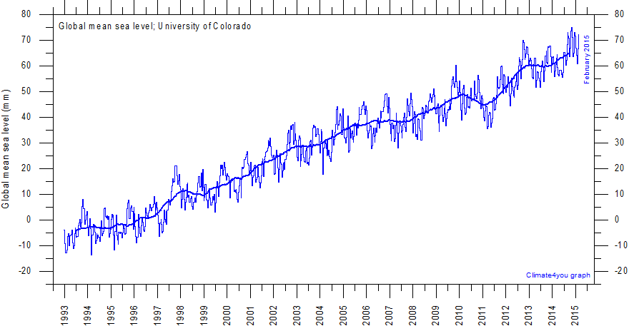
Sea level has been rising much more rapidly than expected.
Look at the graph again.
http://climate4you.com/images/UnivColorado%20MeanSeaLevelSince1992%20With1yrRunningAverage.gif
Sea level has been rising much as it has since we've left the Little Ice Age. What is so unexpected about that?
The obvious reason is that the oceans are warmer than we predicted.
Except they're not - they're missing heat:
http://www.nodc.noaa.gov/OC5/3M_HEAT_CONTENT/heat_content55-07.png
So yes, the models are falsified, and we build new models using what have learned (more rapid heat transfer to the oceans, slightly less mixing of surface with subsurface waters) and try to match the observations.
The problem with that is that you've presented individual implementations of your hypothesis as falsified, but not the *basis* for your hypothesis. With an infinite variety of ad hoc special pleadings available to create an infinite variety of individual implementations, you've set up a tautology that can never be falsified.
-
Re:Welll
To get information, obviously. Maybe you want to know the current temperature at the Guam International Airport, updated in your status bar automatically? Here it is. The add-on just scrapes that page.
-
Little more detailThese aren't traditional clouds that you see in the troposphere (lowest layer of the atmosphere). To get an ozone hole, you need VERY cold temperatures. This happens after during polar night when there is no sunlight for about half the year. The stratosphere is so cold that it can form ice crystals that contain nitric acid. These crystals act as surfaces where ozone destruction takes place. Once the sun rises at the pole (March equinox for the northern hemisphere), the UV light "splits" compounds like CFCs into reactive materials such as Chlorine. The ozone destruction reaction still will not work efficiently without the initial nitric acid/ice crystal surfaces. This is why we don't often see this happening in the Arctic, while the Antarctic shows this signal annually.
http://www.noaa.gov/features/02_monitoring/arctic_thinning.html
The "coldness" of the pole is related to the strength of the winds (polar vortex) around the pole in the atmosphere. The south pole generally has strong winds circling it, which works to cut off the south pole's atmosphere from the rest of the world, especially during the southern hemisphere winter. Part of the reason for a stronger vortex is due to ocean surrounding the south pole on all sides, with land masses far away. In addition, the southern hemisphere in general has more ocean compared to land than the northern hemisphere.
In the northern hemisphere, the polar vortex generally has more waves or pertubations in the polar vortex, which help to mix in air from lower latitudes. Some of this is caused by planetary waves that propagate vertically in the atmosphere. These planetary waves are formed generally due to land masses and mountains affecting the atmospheric flow (not this simple but this is the general idea). Generally, the factor that causes the difference in the north and south polar vortices is land mass.
Now relating this all to climate is a bit tricky. It has been seen that as the troposphere warms (lowest layer of the atmosphere), the stratosphere cools. This has been seen in observations in the last 30-50 years (you may argue that 50 years might not be enough to define a long-term trend). The reason for this cooling is basically radiative balance (though I'm oversimplifying it here). If the troposphere warms due to increased greenhouse gasses, then the atmosphere above must cool above it. There cannot be more heat coming in than is leaving the Earth. A good analog to this is Venus. Venus has huge concentrations of greenhouse gasses. We know its surface is very hot (over 400 degrees C), while its upper atmosphere is much cooler than Earth's (gets down below -110 degrees C, compared to about -80 C on Earth).
The tough part is separating the stratospheric cooling due to greenhouse gasses and ozone destruction from CFCs (although we may know this answer once all the CFCs are out of the atmosphere in the future). Increased greenhouse gasses will warm the troposphere and cool the stratosphere. This will lead to more polar stratospheric clouds, leading to more reactions sites for ozone destruction. More ozone destruction means less UV light is absorbed by ozone in the stratosphere. Less UV absorption means a cooler stratosphere which further intensifies the problem.
-
Re:Yes, of course
How cute, linking to a 2008 (ethanol) crop report in a discussion about the flooding and/or drought in 2011.
$2 billion in cattle lost, $2 billion in cotton lost, $1 billion in corn/wheat/others lost, with the wheat production estimated to be 35% of normal while prices are 139% normal. And that's just Texas, and only "so far this year" (it's expected to stay drier than normal until next year, with La Nina in effect this winter). .
NASS's nationwide crop estimate report for September (summary of the executive summary: corn estimate had to be reduced 3% since August but is still just barely above last year's crop, soybeans are down 7% from last year, cotton is down 9%, oranges are down 8%). If I'm reading the rest right, the rice production estimate is down 20% from last year's production, sugarcane +5%, tobacco -12%, barley -7%, oats -29%, wheat -6%, peanuts -17%, spring and summer potato production were up (+3% and +15% respectively) but the larger fall crop hasn't begun yet (2010 spring summer and fall crops were roughly 2.4M, 1.1M and 36M lbs respectively).
BTW What good is a longer (summer) growing season when it delays fall planting? What good is a hotter summer growing season when July kills your crop?
-
Re:Contentious Subject Matter?
Vanuatu? Texas? Any other data you would like to cherry-pick to use as proof of global climate change? Let me try. Half the planet is in darkness right now so therefore all the of planet is in darkness. WHAT HAPPENED TO THE SUN!?!??!
NOAA say that the sea level is rising.
Humans are responsible for only 4% of CO2 emitted? Well the levels are not increasing by that much per year, so therefore the entire increase fits into that 4%. Greenhouse gases are only 2% of the atmosphere? The scientists know what the makeup of the atmosphere is, and yet thet still claim it will get hotter. And they keep getting proven right.
Except you think that it has been getting colder since 1998, and yet 2005 and 2010 were the hottest years on record. How does that work? And why did you choose 1998 for comparison? It was a El Nino year, and this increases temperatures to abnormal levels. 2010 was a La Nina year, which pushes the temperatures down. And yet, it was still the hottest year on record. Imagine how high it would have been if it had not been for La Nina.
Oh my God, there is more! You keep pushing out the arguments that gets consistantly refuted every single time they get brought up. How boring. Luckily you posted this anonymously, so next time you bring up the same crap nobody can show you up to be deliberately misinforming people.
-
Re:The Alarmism misses a key detail
http://pubs.usgs.gov/fs/fs2-00/
Most of the current global land ice mass is located in the Antarctic and Greenland ice sheets (table 1). Complete melting of these ice sheets could lead to a sea-level rise of about 80 meters, whereas melting of all other glaciers could lead to a sea-level rise of only one-half meter.
So a 15% melting should show a 12m rise in ocean level.
http://www.climatewatch.noaa.gov/article/2009/climate-change-sea-level
Measurements gathered by tide gauges through the 20th century show that global sea level rose at an average rate of 1.7 mm per year – this translates to about two-thirds of an inch per decade. Satellite altimeter data gathered from 1993 to 2003 indicate that the rate of global average sea level rise increased to 3.1 mm per year, or about one and a quarter inches per decade.
There has been an 18 cm rise since 1900, and the rate of rise is increasing.
-
Re:NASA, I am disappoint
-
Re:Global warming has become hopelessly politicize
Try the Global Historical Climate Network: (weather station records from around the world, temperature and precipitation) as referenced at RealClimate.
-
Re:Global warming has become hopelessly politicize
-
Re:So climate science is politics?I found a second chart which shows yearly data for the entire Atlantic basin from 1851 through 2010... http://www.aoml.noaa.gov/hrd/tcfaq/E11.html
It shows 2004 and 2005 as quite active. It also shows 2006, 2007 and 2009 as quite inactive.
In any case, I don't see a dramatic trend in that chart, yet.
Also note that the chart notes that data prior to 1966 is incomplete, so there is actually more activity prior to that than is shown.
-
Re:So climate science is politics?
No they would be asked is the increasing number of hurricanes and their severity consistent with global warming predictions and they would say yes.
That's the point.
That would appear to be incorrect according to this data, at least for the US: http://www.nhc.noaa.gov/pastdec.shtml
Sadly trolls like you don't understand
Personally I hate all of this namecalling that comes with the AGW debate. People are entitled to their opinions without being called idiots or trolls, and AGW supporters are especially bad about that. Yes, publish the facts, publish your opinions, but don't publish opinions as facts, and don't call people trolls or idiots for disagreeing with your opinions.
-
Re:Simplicity wins.
Fax may never die, but its current implementation is tied to a piece of technology that people keep claiming will be on the chopping block before long: the analog dial-up line. At my university, VoIP phones are the norm—and are relatively trivial for IT to hand out—but getting an analog line provisioned is difficult and expensive. Have you ever tried to send a fax from Google Voice or a similar IP-based telephony network? I have, and it doesn't work: the codecs are specifically designed for speech, and the channel does not have enough effective bandwidth to support even a 14.4kbps fax. There are stopgap solutions, of course; Analog Telephone Adapters (ATAs) and/or centralized fax servers save the day. But what about the future, when companies decide to forsake their ISDN/T1-type phone lines altogether and go "all-internet" for their phone connections?
Fax is, for businesses, currently an irreplaceable service. No other service gives them the same traceability, accountability, and legal protections as fax does. Digital signatures do exist, but defending said signatures in court later could get expensive, and I'm not certain if they have ever been interpreted as legally binding. (Anyone, please feel free to refute this.) Trusted timestamps also exist, but the market for them is abysmal. Authentidate, which is marketed by the USPS as an "electronic postmark," costs more than postage and charges for each validation. So, what will happen to fax as the phone network depreciates?
I predict that soon, organizations will be outsourcing their faxing capabilities to third-party providers, which will provide them with an email (or other internet) gateway for faxes. Maybe they'll even connect a printer to keep that same-old fax feel. Eventually, the fax gateways will become popular and numerous enough that they will all realize just how much they're paying for PSTN lines and long distance charges. Then, they'll start peering with one another over encrypted internet links, forsaking the entire phone network and the associated analog transmission protocols altogether. The end result: companies will pay good money to emulate an old, low-resolution raster image transmission protocol, the purpose of which—to squeeze images down a phone line with simplistic compression—having been entirely forgotten.
These are just my totally-uneducated musings, and you should not take them for investment advice. As an interesting side-note, fax (or fax-like protocols) are also used to send weather charts to ships at sea, and these radiofaxes could possibly outlast their phone counterparts.
-
Re:Media Hype(rcane)
By the way, it's name will be Katia. It's almost as big and already as mean as Irene was on Saturday, and has nothing but clear sea between it and the Eastern Seaboard of the USA if the path holds true.
-
Re:It weakened. Period.
I wouldn't put it past the weather channel, but local weather news is even worse. There is a weatherman in North Alabama that will issue his own warnings in order to scoop the other TV station's news show.
The weather channel is so useless that I just monitor NOAA weather and http://www.nhc.noaa.gov/ website. I'll never forget the piece of shit reporter from TWC who made a sensational story after a hurricane in Gulf Shores, AL while parked in front of the only neighborhood with standing water. The hurricane had downgraded significantly prior to landfall, and the reporter must have had a need to juice up the story. Anyway there were only a total of 5 houses that had standing water in them, but the reporter gave the impression that it was a regional disaster in the making.
-
Use the following NHC Links to see Cat 3, 2, 1
The National Hurricane Center found that Irene was CATEGORY 3 off the Florida Coast, and running up the coast over the Gulf Stream. If you do your calculus properly, you have to plan for the fact that Irene could not help but remain a hurricane if (or when) it hits New York City. That would have been a disaster the likes of New Orleans (times ten, then times ten again). President Bush looked the fool by not taking precautionary measures; who could seriously blame President Obama for being Presidential?
CAT 3 (Florida): http://www.nhc.noaa.gov/archive/gtwo/atl/201108281214/index.php?basin=atl¤t_issuance=201108281214
CAT 2 (NC) http://www.nhc.noaa.gov/archive/gtwo/atl/201108270558/index.php?basin=atl¤t_issuance=201108270558
CAT 1 (New York) http://www.nhc.noaa.gov/archive/gtwo/atl/201108260858/index.php?basin=atl¤t_issuance=201108260858Check out the US Geological Survey in a couple more days to view the raw meterological data (usgs.gov)
-
Near and over North Carolina
According to noaa's graphic charts, they give 100% probability of hurricane winds just off the coast of North Carolina. Also check the surface wind history which claims sustained 74mph winds over NC and into VA.
Any small low pressure fronts would've turned it into a much nastier hurricane, instead of downgrading to a tropical cyclone. Imagine if, after Katrina, the president dropped the ball on this.
-
Re:Who cares...
The #7 most costliest "hurricane", before 2004, was Tropical Storm Allison
-
9:00 am Sunday
At 9:00 am Sunday morning, August 28, EDT. According to the Hurricane IRENE Advisory Archive. At that time, it was centered over New York City (it was 40 miles SSW of there an hour earlier). Until then, estimated and measured wind speeds made the system a hurricane.
If you want to dispute the accuracy of NWS current measurements and estimates, then research how they do it and dispute properly. They use recon aircraft, doppler radar, satellite imagery, balloons, and ships, in addition to buoys and automated surface observation systems, to measure and estimate wind speeds. If you want to dispute the NWS's predictions, then either learn meteorology and forecast models to prepare yourself, or compare past predictions to later observations. If you want to dispute the NWS's warning wording, then compare predicted conditions and their real world impact to the NWS's wording. If you want to dispute the media's hype, then compare their hype to the NWS's warnings, and have fun.
But do not ask such an amazingly easy to answer question like "When Did Irene Stop Being a Hurricane?" in order to stir provocation, without answering it. And do not look at some buoy and automated surface observation system data and claim there was no hurricane just from that.
-
ORIN7
Here is the link to ORIN7 which shows winds hitting 70 knots and a central pressure of 28.50. Granted, the sustained winds show slightly below cat 1 at the surface, the winds were reported at 20 to 30% stronger at 1000 feet. And windspeed is not the only measure - central pressure is used too. 28.50 is on the border between cat 2 and 3. This storm was somewhat stillborn when it came to the winds.
-
Here's some data
Here's some data Cliff Mass must have overlooked:
Here's a helpful map with data:
http://www.wunderground.com/hurricane/at201109.aspHere are the National Hurricane Center reports:
http://www.nhc.noaa.gov/archive/2011/refresh/IRENE+shtml/120913.shtml?
* Note the Wind Speed Probability reportsThey also provide this:
http://www.nhc.noaa.gov/refresh/graphics_at4+shtml/085722.shtml?swathThe Wikpedia article is well-footnoted:
https://secure.wikimedia.org/wikipedia/en/wiki/Hurricane_Irene -
Re:Altitude?
Does it matter at what altitude the wind speeds are measured?
Yes, it does. From this NOAA paper:
[T]he following reduction factors are recommended for reducing flight-level winds in the inner core of a tropical cyclone to the surface (33 ft) level: for the 700 mb level, R = 0.90; for the 850 mb level (commonly flown in tropical storms), R = 0.80. For investigative flights at 1,000 ft, R = 0.85. As significant variations from these means have been noted in individual storms; these guidelines can be modified as conditions warrant. Storm-to-storm variability will primarily be influenced by wind speed, cyclone convective intensity, and sea-surface temperature.
In other words, for example, when the plane is flying at an altitude such that it measures an air pressure of 850 mb, the measured wind velocity is multiplied by 0.80 to produce the estimate of wind speed at the surface. (Note that all "surface" measurements are actually standardized to be 33 ft up.)
-
Total Electron Content
This work actually measured Total Electron Content, not electron density (a related, but different, phenomenon).
Maps of vertical and slant atmospheric electron density over the U.S. are here.
-
Re:PR Is just a step up from a 3rd world country
Luis was a really scary one, it was going to hit us directly. It was cat4 almost cat5. I had saved a image of when he was just east of us but lost it in the last reformat. Here is one from Tracking the Tropics, if that thing had hit us we would probably be still picking up debris.
-
Re:The real problem is openness
You want Mann's data and algorithms for the original 1998 hockey stick graph? They are here.
You want the updated data from 2008 and 2009? They are here and here.
More links to other forms of climate data and methods are here.
The arguments that climate scientists are not releasing their data and methods are no longer viable because they have now for the most part.
-
Re:We're not shaking in our boots.
It's predicted to be a category 1 or 2 when it hits NJ and could still be a hurricane when it hits NYC. Although it could be *just* a tropical storm which only causes heavy rainfall and moderate to sever flooding.
http://www.nhc.noaa.gov/graphics_at4.shtml?5-daynl?large#contents And NYC is already developing an evacuation plan in case the storm does come close.
http://gothamist.com/2011/08/25/hurricane_irene_is_coming_heres_a_m.php#photo-1 -
Re:Faux News admitted the Earth is getting warmer
Apparently you do not live in a cold climate, or didn't turn on the news.
http://notrickszone.com/2011/02/21/moscow-shivering-in-coldest-winter-in-100-years/
http://en.wikipedia.org/wiki/Winter_of_2010%E2%80%932011_in_Great_Britain_and_Ireland/Even Florida was cold.
http://www.palmbeachdailynews.com/blogs/content/shared-blogs/palmbeach/weather1/entries/2011/03/09/florida_winter_was_states_10th.html/Whether it's a naturally occurring cycle, or human caused, we need to figure out the root cause so we can figure out how to counteract the effects.
Can you explain how you would counteract a naturally occurring cycle as explained in the NOAA article? And, more importantly, why would you want to?
The main culprit behind the cold temperatures in December 2010 was the same one which caused the cold winter of 2009-2010; a strongly negative North Atlantic Oscillation (NAO) and Arctic Oscillation (AO). When these atmospheric oscillations are in the strong negative phase, they essentially “flip” the weather pattern across North America, with upper-level high pressure and relative warmth over Greenland and Northeastern Canada and upper-level low pressure and cold over the eastern Continental United States, including Florida (Figure 1). This pattern forces the jet stream to plunge south from northern Canada into the southeastern U.S., transporting Arctic air masses into Florida.
http://www.srh.noaa.gov/images/mfl/news/2010WxSummary.pdf/It is never good when non-native flora or fauna are introduced into an ecosystem--there are always consequences. Messing around with established weather patterns/phases could be catastrophic.
-
Re:Reporting from Florida...
Appears that NOAA's latest revision has it pushed out to sea a bit more than yesterday. GP may get a reprieve.
http://www.nhc.noaa.gov/refresh/graphics_at4+shtml/143914.shtml?50wind120?large#contents
-
Re:Does anyone have a link...
-
Re:Does anyone have a link...
To the actual NOAA release, rather than the hideously dumbed-down MSN rehash?
http://www.alaskafisheries.noaa.gov/newsreleases/2011/orangesubstance081811.pdf
Although it's not much more informative...
-
Observed data
According to the Mauna Loa Observatory we passed 350 ppm annual average CO2 in 1990. Next April we're scheduled for our first 400 ppm observation and five years later our last under 400 ppm observation if trends continue. Since there's no way anybody's going to reverse the trend before then, 400 ppm is not an achievable target. 450 ppm isn't even an achievable goal. 500 might be doable - that's a 60 year target.
-
Re:Perseids stick around a few weeks
By the time the moon isn't an issue, it's going to be far enough off-peak that you'll be as (or more) likely to see a non-perseid than a perseid. Either a random, non-show meteor, or something related to the many other minor showers going on right now.
As far as auroras go, no. If you look at the kp-index map, you need a hella powerful (> 9 kp index) geomagnetic storm to see anything down there. The most recent big storm got up to 7 or 8 IIRC, and it only did that while it was still bright on this side of the planet. You can sign up for space weather alerts from NOAA.
-
Re:Jeep Rice
Weird. I did some checking and apparently his real name is Jeep Rice. Really!
Keep Rice was a typo, and that typo is now being propagated all over the Inter-Tubes by trusting bloggers and news aggregators who don't check their facts. (And speaking of Inter-Tubes, he works at the Ted Stevens Marine Research Institute.)
Just add a couple of spoilers on it and you will have your Jeep Rice.
-
Jeep Rice
Weird. I did some checking and apparently his real name is Jeep Rice. Really!
Keep Rice was a typo, and that typo is now being propagated all over the Inter-Tubes by trusting bloggers and news aggregators who don't check their facts. (And speaking of Inter-Tubes, he works at the Ted Stevens Marine Research Institute.)