 Slashdot Mirror
Domain: californiacoastline.org
Stories and comments across the archive that link to californiacoastline.org.
Comments · 43
-
Re:Barbara Streisand wants her meme back...
If you're going to cite the Streisand Effect, don't forget to cite the Streisand Effect. There, FTFY.
-
Re:This has been done before, and it failed.
Yes, the DVDA attempt to prosecute anyone who even linked to a host of the deCSS "liberated" decryption key was the first case of the Streisand effect. It evoked an outraged response from the community, including a very effective EFF Blue Ribbon campaign for Freedom of Speech Online, which is still active. I still own several t-shirts with the CSS key printed on the back. This was way back in like 1999 or something.
But it wasn't named the Streisand Effect until Barbara Streisand sued the California Coastal Records Project (an awesome site) for publishing pictures of her estate on the coast of California. When this news hit the web, the pictures were copied far and wide in support of CCRP. And Streisand lost her lawsuit.
-
Re:They should share it with everyone...Here's a question, though.
How is this different from a LANDSAT photo? From NewsCopter 1 over a fender-bender in the Maze? From me flying 1,000 feet overhead in a rented Cessna and taking pictures? (Smile!) From setting up on a hilltop with a monster telephoto lens and an 8 megapixel SLR? Barbara Streisand? If it's just resolution... Cessna@1000 or telephoto lens beats out any spy satellite. If it's law... well, no, it isn't. See previous Cessna/Streisand reference.
The only difference is who is taking the pictures. If the NSA/CIA/NRO etc. are taking pictures, I'd like to see mine. I want to make sure they get my good side. * drops pants *
In all seriousness. With LANDSAT becoming a thing of the past, we need a source of high-quality overhead images to get real work done. As the articles mention, this is gold for people doing work with flood control, forest management, fire abatement, urban planning, ice pack monitoring, wildlife surveys (best way to count migrating wildebeest! Especially those New Jersey wildebeest). Gimme some infrared wavelengths that penetrate water vapor, let's do highway traffic flow analysis and realtime metering signal control or highway patrol dispatch, rain or shine.
Plenty of legitimate, useful, fully legal uses. Think of it this way: it's a civilian benefit from a military budget. How cool is that?
-
Re:Is it even possible for YouTube to comply?
The only way this is going to go away is when people lose interest . . . which isn't going to happen any time soon now that there's constant media coverage because she was foolish enough to file suit.
One of my local television news shows referred to this as the "Streisand Effect." For those that don't get it: a few years ago, Barbra Streisand sued the makers of a http://californiacoastline.org/ for $50 million because their aerial photographic survey of the California coastline had images that included her coastal property. The media coverage of her outrageous lawsuit resulted in her property being one of the most looked at/downloaded images on the Internet. Heck, I wouldn't have looked if I hadn't learned about it on Slashdot. -
Barbra Streisand
At what point will Barbra Streisand file a lawsuit against them, for posting pictures of her Mars colony?
http://www.californiacoastline.org/streisand/lawsu it.html -
Re:This is only going to get worseThe CA Coastline Project already has this multi-year comparison capability.
Here's an example where you can compare development at the Big Dipper roller coaster here in Mission Beach between 1972, 1979, 1987, 2002, and 2004. (The 1989 dataset starts about two miles up the beach).
Staying on topic, here's a nice view of the San Onofre nuclear reactor up the coast in Camp Pendleton before construction, during construction, and as it stands today.
-
Google maps is ok, but not the best...GlobalXplorer still walks all over Google maps for zoom and clarity. They get about 10x closer than the highest-resolution Google maps for quite a few areas (and the maps are less than 3-4 months old).
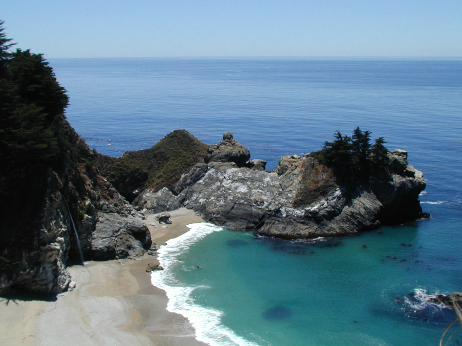
And let's not forget about the California Coastline project (helicopter taking VERY high resolution images every 500' along the entire California coast.
I found some sort of easter egg there. Zoom in on that center photo, then look in the bottom-left corner of the image, right up near the waterline by the tidewall... is that a mannequin of a naked woman (with hair too!), or is that painted on the landscape there? Or is it really a cadaver? A sunbather? I can't quite tell...
And of course, there's Map24, which has, hands-down the best mapping UI out of anything I've ever used.
Now I just wish some of these sites would support "mobile" directions and maps. Hrmph, Google's "Directions" link on maps.google.com doesn't even work at all, it just reloads/refreshes the main map view in anything but MSIE. What a waste.
-
Google maps is ok, but not the best...GlobalXplorer still walks all over Google maps for zoom and clarity. They get about 10x closer than the highest-resolution Google maps for quite a few areas (and the maps are less than 3-4 months old).
And let's not forget about the California Coastline project (helicopter taking VERY high resolution images every 500' along the entire California coast.
I found some sort of easter egg there. Zoom in on that center photo, then look in the bottom-left corner of the image, right up near the waterline by the tidewall... is that a mannequin of a naked woman (with hair too!), or is that painted on the landscape there? Or is it really a cadaver? A sunbather? I can't quite tell...
And of course, there's Map24, which has, hands-down the best mapping UI out of anything I've ever used.
Now I just wish some of these sites would support "mobile" directions and maps. Hrmph, Google's "Directions" link on maps.google.com doesn't even work at all, it just reloads/refreshes the main map view in anything but MSIE. What a waste.
-
Spotting environmental crimes
Reminds me of the California Coastline Project that got launched a few years ago. The idea behind it was to help people spot environmental crimes, building violations, etc. I wouldn't be surprised if Google's maps will soon be used for similar things - although it would help to have a more frequent update than 18 months, and to be able to browse in the past. While that information is available now (for a fee), it'll have quite a different impact once it's free.
-
Re:Standard SLAPP suit
You beat me to it! Damn you!
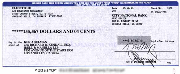
Babs got slapped back under California's anti-SLAPP statute. After losing her $50 million lawsuit, she had to fork over north of a hundred large for attorney's fees after some guy had the temerity to post an aerial photograph of her palatial mansion that would make Ken Lay jealous. Her attorney's name - I'm not making this up - was John Gatti. -
Re:Standard SLAPP suit
You beat me to it! Damn you!
Babs got slapped back under California's anti-SLAPP statute. After losing her $50 million lawsuit, she had to fork over north of a hundred large for attorney's fees after some guy had the temerity to post an aerial photograph of her palatial mansion that would make Ken Lay jealous. Her attorney's name - I'm not making this up - was John Gatti. -
Some GPS resources
This isn't my web site but I wish it were:
http://www.geosnapper.com/
There exist Japan only (not ever marketed in the US) point and shoot cameras that already record GPS data directly. (Rioch... and some other brand I haven't heard of.)
And of course various Nikon pro models have this capacity, such as that used here:
http://www.californiacoastline.org/
In the same vein, check out:
http://apps.ecy.wa.gov/shorephotos/index.html
I haven't evaluated this: http://www.robogeo.com/home/
But I do own this, and it works well, as advertised to get a GPS read for each time at which you take a picture: http://www.geospatialexperts.com/
At the above location, they happen to sell the Ricoh model that can record GPS out of the box. -
Re:been done.. ask around
http://www.californiacoastline.org/
-
Just be sure to turn your camera off when...
Just be sure to turn your camera off when you drive past Barbra Striesand's House.
-
CA coastal access database
-
CA coastal access database
-
Alternative Methods
-
Re:Honestly? So what?
I can walk out my door right now, with my camera, and snap pictures of every house on my street.
What'll that get me? Not much, except a bunch of pictures of houses on my street.
Umm... That is highly likely to get you at least a conversation with cops.
That might also get you sued (see e.g. http://www.californiacoastline.org/streisand/lawsu it.html). That might also get you arrested (I, personally, have been arrested for taking pictures of an industrial plant from a public sidewalk).
-
URLs
-
URLs
-
California Coastal Records Project URL
A bit of googling turned it up...
http://www.californiacoastline.org/
Enjoy
Gr*g -
it http://www.californiacoastline.org/
http://www.californiacoastline.org/
has a link to the latest in Barbra Steisands lawsuit.. Her house is on the coast and is included in there CA coast photo collection.
This is the page on the lawsuit with links to stories and a picture of her house on it.. Funny those guys. I hope they win. -
Re:So...
This site is being sued because one small portion of one (out of 12,000) photos of the california coastline happens to contain a photo of her house.
Damned conservationists! -
That California Coastline is awesome
I can see my house, where I used to work, people on the beach, Ocean Avenue in Carmel, Bubba Gumps in Monterey (and all of Cannery Row), Monterey Bay Aquarium, Pebble Beach, etc.
I'm tempted to grab all the hi-res pictures and creating a slide show moving along Del Monte beach all the way to Carmel Beach. You can see the house that Frank Lloyd designed (that Sammy Hagar used to live in) here.
Ok, I'm bookmarking this. You can even see the Monterey Presidio that they shut down slightly before Sep. 11th (security was tightened from an unknown threat?). Interesting, indeed.
-
Wait a sec...
This is cleary explained on the site:
Privacy Concerns
We are aware that we have photographed a number of homes in the process of documenting the California Coast. The California Coast is a unique and beautiful place, and those people who have chosen to live on it have made the coast a part of their lives, and their lives a part of the coast. It should come as no surprise that the public at large would be attracted to view this beautiful place some call home. We have little sympathy for those who would feel that in order to enjoy the beauty of the coast that they must deny others access to it.
All of the photographs on this site have been taken from a public place and in compliance with applicable Federal and State laws. (emphasis mine)
Please be sure to review some of the highest resolution photographs before forming your own opinion. You cannot see much detail, for example, identify individuals or see into a house. Also, as discussed in the next section, this information is available elsewhere.
A very good book about how technology will affect the privacy of all of us is The Transparent Society: Will Technology Force Us to Choose Between Privacy and Freedom? by David Brin. -
Re:oh no!!
I think encouraging Trey and Matt to do an(other?) episode on people who think they should be ruling the world is an excellent idea.
By the way, here's the direct link to the high-res mansion shot: huge image -
Re:my house!The pictures don't really give a sense of height, which may be confusing. The rocks on the beach are actually quite tall, the freeway is probably a good 20 feet above sea level at that point, and the houses/railroad/etc. are much higher. This part of California doesn't really get big sea surges (except during winter storms, and they come from the northwest), so it isn't a problem even for the road.
Actually, a bigger problem here are landslides. What you call a "cliff" is actually a mountain, and in wet (el nino) years the mountains tend to "erode" a little faster. In the picture (easier seen in the big picture) you can see a landslide that took out a bunch of houses here a few years ago. Notice how a chunk of the hill has slid into town. I hope it wasn't where the poster lived! -
Re:my house!Sweet! Not too far from my home town
-
Re:Only a week old.
Maybe they would have had more hits if they'd have gotten a better picture of the nudist beach.
Great place, was there for the 4th. -
Re:Why illegal?
I couldn't make the boulders out well in the newspaper's photograph, so here is the medium size image of the Ritz Carlton Half Moon Bay , the beachfront, and the boulders taken from the website.
It is identified as: N37 26.03 W122 26.84 Image 6133 Mon Sep 30 16:05:57 2002 -
This was actually Useful!
-
Re:Why not just use a digital camcorder?
I wonder if there isn't some other motive here, requiring high-res images
My guess is that they just wanted to get some really cool desktop pictures out of the thing. -
Clicky Link
http://www.californiacoastline.org/cgi-bin/image.
c gi?image=6133&mode=sequential&flags=0
Sorry I forgot to put A tags in the first one.
Tim -
my house!
holy crap, you can see my house!
-
California CoastlineIt's not all photographed yet, but you can see what they've got so far.
-
California CoastlineIt's not all photographed yet, but you can see what they've got so far.
-
California CoastlineIt's not all photographed yet, but you can see what they've got so far.
-
California CoastlineIt's not all photographed yet, but you can see what they've got so far.