Slashdot Mirror
Domain: nasa.gov
Stories and comments across the archive that link to nasa.gov.
Comments · 16,365
-
Hubble has SEVERAL proposed replacements
The comment about not having a replacement isn't accurate, here are a few of the NGST (Next Generation Space Telescopes), that NASA wants to loft:
http://sim.jpl.nasa.gov/beyond/
http://tpf.jpl.nasa.gov/
http://lisa.jpl.nasa.gov -
Hubble has SEVERAL proposed replacements
The comment about not having a replacement isn't accurate, here are a few of the NGST (Next Generation Space Telescopes), that NASA wants to loft:
http://sim.jpl.nasa.gov/beyond/
http://tpf.jpl.nasa.gov/
http://lisa.jpl.nasa.gov -
Hubble has SEVERAL proposed replacements
The comment about not having a replacement isn't accurate, here are a few of the NGST (Next Generation Space Telescopes), that NASA wants to loft:
http://sim.jpl.nasa.gov/beyond/
http://tpf.jpl.nasa.gov/
http://lisa.jpl.nasa.gov -
Re:ISS
Not sure about the ISS, but The Shuttle uses S-Band and I doubt the MUF will get high enough to block S-Band.
-
Re:short rambling on Natural Radio
-
Re:short rambling on Natural Radio
-
Re:Media Wall
-
Already sent
We've already sent the first message to an extraterrestrial civilization.
Of course, anyone who used Usenet 20 years ago has some rudimentary experience in this sort of conversation. Back then, it took between 3 and 10 days for replies to make it back to the original poster, because much of the traffic was sent via 2400 baud modems in the middle of the night. Conversations were -
Re:Why look?
But what's the point? The only confirmed life on other planets far away will be from "Intellegent Life" (Meaning they have access to radios).
Maybe not. NASA has plans to some day launch a deep space interferometric array of Hubble-class telescopes that will be able to resolve a 25x25 pixel image of an Earth-size planet 50 light years away, and determine spectra from its atmosphere. If they find oxygen, then they can be pretty sure they've found life.
-
Helios footageOn the Nasa site there are some movies of the Helios.
For the paranoid:
http://www.dfrc.nasa.gov/gallery/movie/Helios/ind
e x.html -
Re:Where's the ISS ?
Before you ask, yes I got the joke. And have an answer. It's right here
-
Why pay for this 1/8 model....When you could swipe the real thing from Gorky park with a forklift and a tractor-trailer.
It's up on cinder blocks... kinda sad, really.
-
Let me address something here...
-
space.com slashdotted... new link
Space.com's link for the Perseid meteor shower information has officially been slashdotted.
You can view similar information (or at least good information on the annual Perseid meteor showers) on nasa.gov. Yummy tasty.
-
A better picture
This is a picture along the same lines, only IMHO more awe-inspiring.
-
Re:missing areas
Looks like a problem with the mapping, unless Syria is a very dark place, if you take a look at a high-res map there's still a little gap in there, but it's less pronounced.
-
The K5 map is better :)
-
Re:Wierd places
Oil rigs and fishing vessles most likely, you see them in the Japanese waters too. I guess some of the light could be part of the British fleet
There was a similar story to this posted on K5 a few months back, in fact I think that map was even more impressive, you can even make out the grid structures on the East coast. -
Re:Atlas of Worldwide Pollution
You may want to check the following: http://antwrp.gsfc.nasa.gov/apod/ap010709.html
-
Re:canada?
Ya, it kind of annoyed me that the northern areas of canada were cut off. They just barely got edmonton on there. It would have been neat to see some of the northern towns in the yukon and the territories (and for you americans, Alaska). There is one "earth at night" image that a different poster (jmorzins) linked to, Here, that shows all the way up to the north pole. It is interesting since every little town and research site up there seems to have at least one light turned on.
-
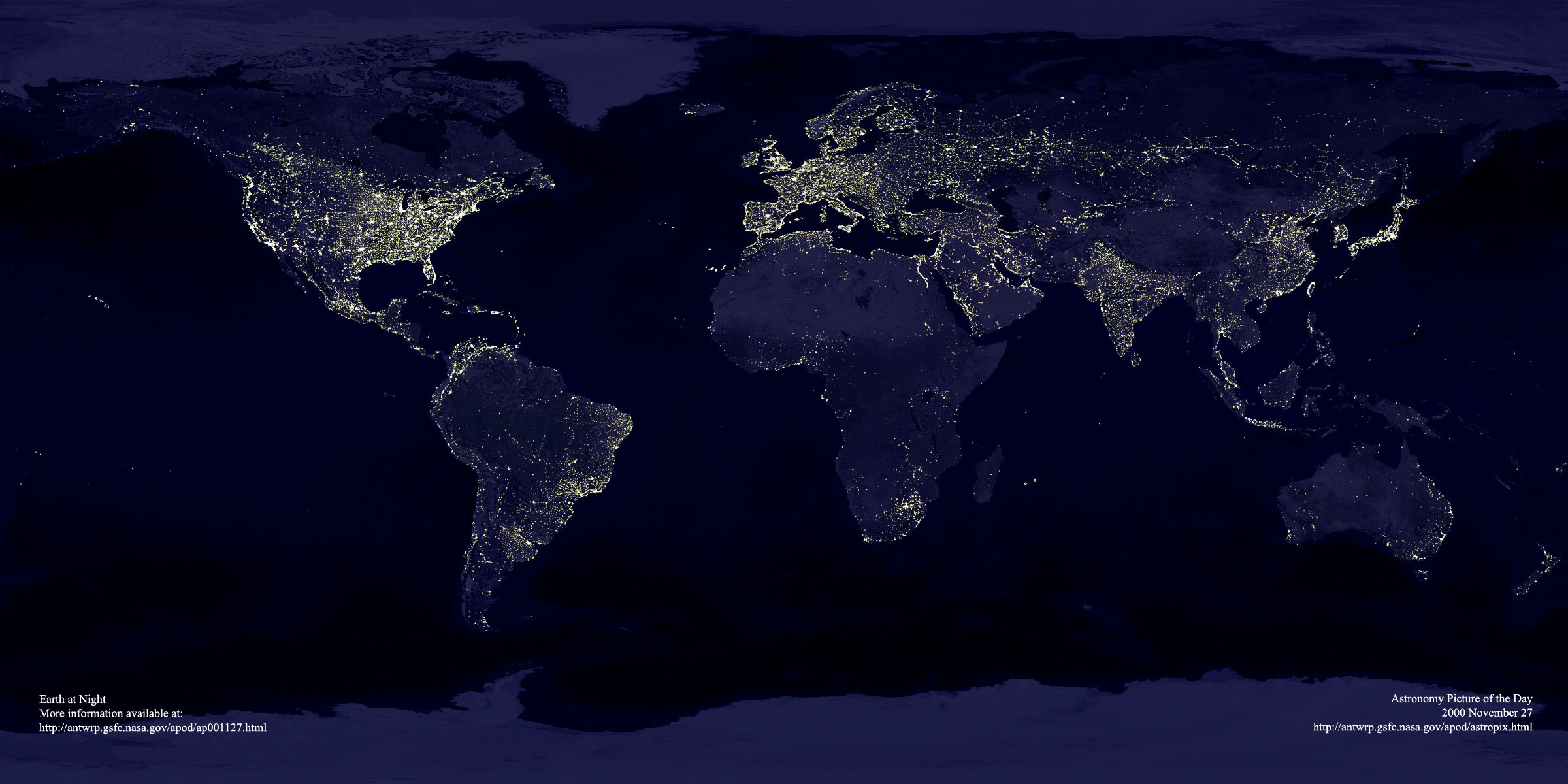
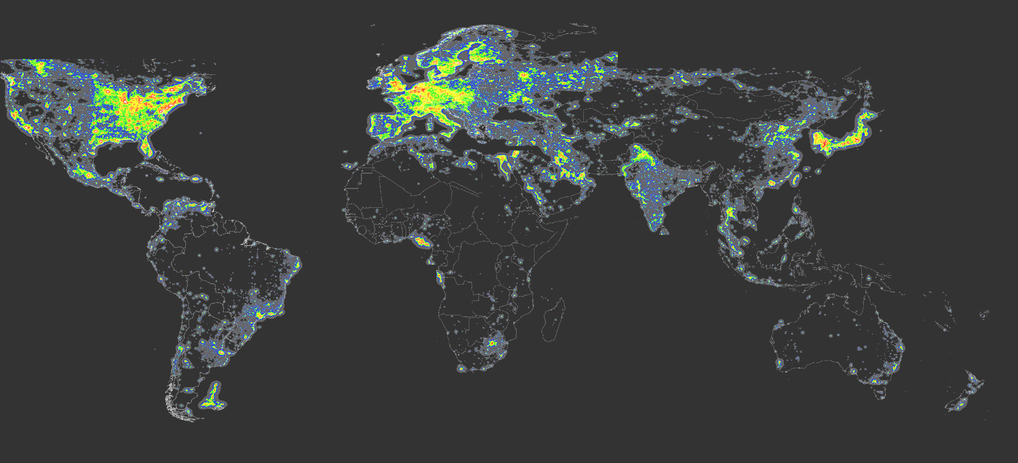
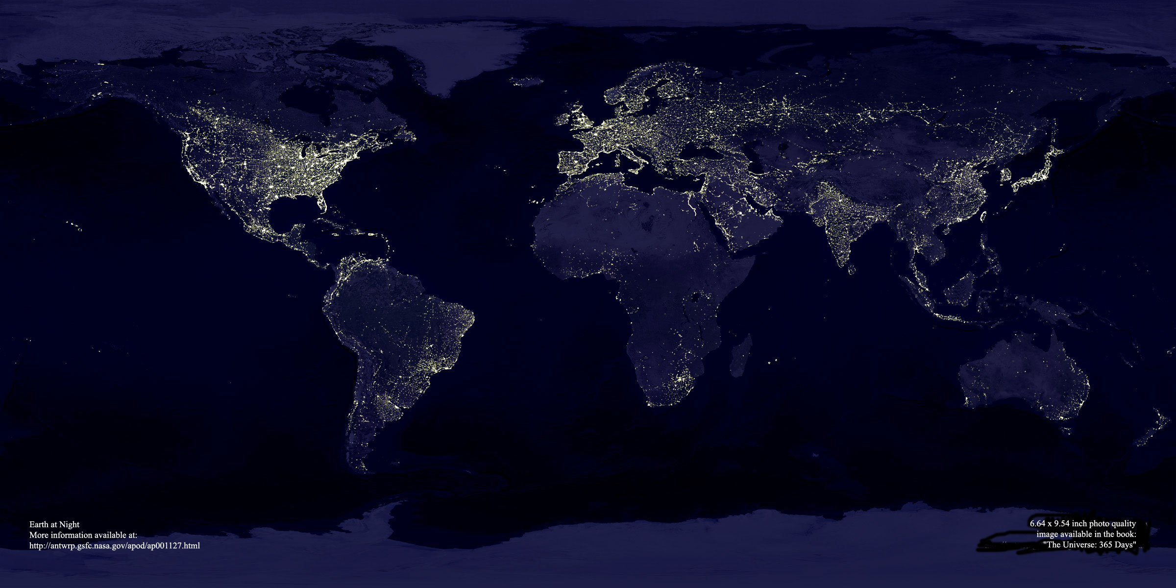
DMSP earthlights imageSome of these satellite photos are really fun. One of my favorites also uses data from the Defense Meteorological Satellites Program (DMSP). They spent months taking pictures of the night time earth, and assembled a beautiful composite image of all light-emitting sources on the earth's surface.
It's a map of light sources, and shows some really interesting structures. The Nile is much brighter than the rest of Egypt, the central U.S. is a grid of cities, and there's a railroad stretching across Russia to the Pacific Ocean.
A small version of the image was an astronomy picture of the day last November (http://antwrp.gsfc.nasa.gov/apod/ap001127.html), and a larger version of the image is also available (http://antwrp.gsfc.nasa.gov/apod/image/0011/eart
h lights_dmsp_big.jpg). There's a short writeup at http://earthobservatory.nasa.gov/Study/Lights/. -
DMSP earthlights imageSome of these satellite photos are really fun. One of my favorites also uses data from the Defense Meteorological Satellites Program (DMSP). They spent months taking pictures of the night time earth, and assembled a beautiful composite image of all light-emitting sources on the earth's surface.
It's a map of light sources, and shows some really interesting structures. The Nile is much brighter than the rest of Egypt, the central U.S. is a grid of cities, and there's a railroad stretching across Russia to the Pacific Ocean.
A small version of the image was an astronomy picture of the day last November (http://antwrp.gsfc.nasa.gov/apod/ap001127.html), and a larger version of the image is also available (http://antwrp.gsfc.nasa.gov/apod/image/0011/eart
h lights_dmsp_big.jpg). There's a short writeup at http://earthobservatory.nasa.gov/Study/Lights/. -
DMSP earthlights imageSome of these satellite photos are really fun. One of my favorites also uses data from the Defense Meteorological Satellites Program (DMSP). They spent months taking pictures of the night time earth, and assembled a beautiful composite image of all light-emitting sources on the earth's surface.
It's a map of light sources, and shows some really interesting structures. The Nile is much brighter than the rest of Egypt, the central U.S. is a grid of cities, and there's a railroad stretching across Russia to the Pacific Ocean.
A small version of the image was an astronomy picture of the day last November (http://antwrp.gsfc.nasa.gov/apod/ap001127.html), and a larger version of the image is also available (http://antwrp.gsfc.nasa.gov/apod/image/0011/eart
h lights_dmsp_big.jpg). There's a short writeup at http://earthobservatory.nasa.gov/Study/Lights/. -
DMSP earthlights imageSome of these satellite photos are really fun. One of my favorites also uses data from the Defense Meteorological Satellites Program (DMSP). They spent months taking pictures of the night time earth, and assembled a beautiful composite image of all light-emitting sources on the earth's surface.
It's a map of light sources, and shows some really interesting structures. The Nile is much brighter than the rest of Egypt, the central U.S. is a grid of cities, and there's a railroad stretching across Russia to the Pacific Ocean.
A small version of the image was an astronomy picture of the day last November (http://antwrp.gsfc.nasa.gov/apod/ap001127.html), and a larger version of the image is also available (http://antwrp.gsfc.nasa.gov/apod/image/0011/eart
h lights_dmsp_big.jpg). There's a short writeup at http://earthobservatory.nasa.gov/Study/Lights/. -
Re: enviroweenie type of project
Actually, from having talked to the people working on the Triana project, one important function would be to gather global warming data. As long as we still have people who "don't believe in global warming" and refer to scientists as "environweenies," I think it's important to gather enough information to prove that it's a real problem.
-
Re:Other reasons besides politics>>instruments on Triana would have a unique perspective for studying the Earth's atmosphere, climate and seasonal changes.
> I thought there were some weather satellites. What functionality does this satellite possess over the others?
I suspect one factor is the combination of sensor packages all taken from the same perspective. This isn't just a simple monochrome weather camera. Secondly, weather satellites are geostationary meaning they go behind the Earth as the spot they orbit goes dark. What if something exciting/interesting happens when you're on the darkside?
There are two packages on the spacecraft:
The fact that you get a "Kodak Moment" out of the photography is somewhat a nice secondary byproduct (even if it was the initial inspriation).
-
Re:Other reasons besides politics>>instruments on Triana would have a unique perspective for studying the Earth's atmosphere, climate and seasonal changes.
> I thought there were some weather satellites. What functionality does this satellite possess over the others?
I suspect one factor is the combination of sensor packages all taken from the same perspective. This isn't just a simple monochrome weather camera. Secondly, weather satellites are geostationary meaning they go behind the Earth as the spot they orbit goes dark. What if something exciting/interesting happens when you're on the darkside?
There are two packages on the spacecraft:
The fact that you get a "Kodak Moment" out of the photography is somewhat a nice secondary byproduct (even if it was the initial inspriation).
-
Re:Other reasons besides politics
I thought there were some weather satellites
The site http://www.ssec.wisc.edu/data/ has some nice pictures, including full-hemisphere views from GOES-8 and GOES-10.
Of course these are in a fixed position with respect to the earth's surface, while GoreSat would have been fixed with respect to the sun's position.
Also of interest is the SOHO spacecraft currently orbiting L1 and observing the sun.
-
In Case You Don't Know What Triana Is...
Visit their website. Check out their photo collections in the making as well.
-
In Case You Don't Know What Triana Is...
Visit their website. Check out their photo collections in the making as well.
-
Re:How many birds can fit in Lagrange 1?
-
Re:How many birds can fit in Lagrange 1?
-
Computer Shows
Being from the DC area, if you want inexpensive computer components I would urge you to actually try the Market Pro Computer Show and Sale. You can find information about the shows at this link.
Although they are advertised as you said "'Comptuer Show and Sale and Monster Truck Rally' events advertised constantly on cheapo UHF stations," they are mostly filled with local (DC/MD/VA) vendors and some out-of-area (PA/NY/NJ) sellers who sell computers and computer compenents. I would not recommend this show for any novice computer user. I do extensive research of the product(s) I want to buy before I go there; because the phrase caveat emptor is very appropriate.[1]
However, since you mentioned you wanted more of a swap fest, this may not be for you. You might try...
There are also fedral auctions at Goddard Space Flight Center (GSFC) which sell many components. However, most of them are really old government surplus. My step-father once picked up three 9 inch floppy drives there (it was part of a pallet where he wanted the plotter). I don't know the URL of the auctions but you can goto the GSFC Website and search for it. Google may work as well.
Finally there are HAMfests in the DC area you can go to. Not being a HAM operator/user I don't know of any. Once again, google may help.
[1] My friend once claims that he bought a motherboard from a computer show that was not FCC compliant (made in China) and interfered with radio devices. I have only bought a bad harddisk once which the (local) vendor was happy to replace. Again, caveat emptor.
-
D.C. Area - NASA Goddard
For those in the D.C. area, NASA Goddard has surplus property auctions. I've never been, but it looks like they have some pretty cool junk.
-
Re:Magnetism and Electrostatic forces seemed weakThe tanks are refilled until shortly before launch. One of the umbilicals connects to the liquid hydrogen tank. It's removed just minutes before launch.
Note that the hydrogen is circulated through the engine feed pipes to chill them. This means that the hydrogen isn't just sitting in the tank, it's moving through pipes which are not as well insulated as the tank, which would cause warming and venting.
I also see that the pressure relief valve is set at 38 psi, but during prelaunch the tank is pressurized to 44.1 psi -- unless there's something not mentioned on that page, as long as the tank is at the 44.1 pressure needed for ignition, there will be continual venting.
-
Re:Magnetism and Electrostatic forces seemed weak
You must be talking about H2 gas. It couldn't possibly leak that much liquid H2. According to this, the hydrogen tank holds 1,500,000 litres of H2, meaning that it would be entirely depleted in 1.5 hours.
-
RoboCup 2001 in the NewsHere are some pointers to media reporting on RoboCup 2001 (a few items discuss related events):
"Robo-cup" (audio, requires player) by Lee Gutkind, National Public Radio, Weekend All Things Considered, 28 July 2001
"RoboCup 2001 Marks SGI's Second Year of RoboCup Federation Sponsorship" (press release), PR Newswire, 1 August 2001
"Robot Competitors Meet on a Soccer Field of Dreams" (free registration required) by Jeffrey Selingo, New York Times, 2 August 2001
"RoboCup: Where Bots Kick Butt" by Jason Spingarn-Koff, Lycos News, 2 August 2001
"Rush is on for 'HAL'-like computer to perfect A.I." by Winda Benedetti, Seattle Post-Intelligencer, 3 August 2001
"Robot world cup kicks off", BBC, 3 August 2001
"RoboCup 2001 boots up" by Helen Pearson, Nature Science Update, 3 August 2001
"Blutgrätschen ohne Blut und Beine", stern.de, 3 August 2001
"Roboter aus 23 Ländern tragen Fußballweltmeisterschaft aus", Net-Business Online, 3 August 2001
"RoboCup 2001, il calcio visto dai robot", Punto Informatico, 3 August 2001
"Building a better goalie (buzz, whir)" by Gregory Roberts, Seattle Post-Intelligencer, 4 August 2001
"Man and machine take the field" by David Olsen, Seattle Times, 4 August 2001
"Robots Storm the Soccer Field" by Maria Godoy, TechTV/Tech Live, 6 August 2001
Information about live Webcast of Botball finals (an event distinct from Robocup) on 7-8 August
-
Ho hum
These kinds of feats just don't have the glamor they used to. Especially since his gondola is all tricked out with hi-tech stuff. The balloon even flies itself so that he can sleep. I understand that this is a very tough feat, particularly since this is his 5th attempt at it, but it just doesn't have that extra dimension that makes it very exciting (it isn't a first circumnavigation, because that was done in the 16th century; it doesn't demonstrate the possibilites of future transport or a smaller world; it doesn't have great political implications; nor is it a demonstration of new technologies and engineering). I doubt that 100,000 people will storm the landing zone in celebration if he does make it around.
-
Re:When point sources aren't points any more
The Keck Interferometer is now in operation, but it will be nulling in June 2002.
-
Re:When point sources aren't points any more
The Keck Interferometer is now in operation, but it will be nulling in June 2002.
-
Re:Resolution? Landsat?Actually, a better description of the SRTM data products can be found at:
http://www.jpl.nasa.gov/srtm/datafinaldescription
s Note the the 30m resolution is for a "seamless" National DEM database. Interpolating (up) to a 30m resolution is intended to correspond to other satellite/digital data already interpolated to this semi-"standard" resolution. Some public data products will (eventually!) be available at a higher spatial resolution. (Frankly, 30m resolution may be overkill for Kansas but hardly sufficient for half of Colorado!)
More information about the potential resolution of this radar data can be found at:
-
Re:Resolution? Landsat?Actually, a better description of the SRTM data products can be found at:
http://www.jpl.nasa.gov/srtm/datafinaldescription
s Note the the 30m resolution is for a "seamless" National DEM database. Interpolating (up) to a 30m resolution is intended to correspond to other satellite/digital data already interpolated to this semi-"standard" resolution. Some public data products will (eventually!) be available at a higher spatial resolution. (Frankly, 30m resolution may be overkill for Kansas but hardly sufficient for half of Colorado!)
More information about the potential resolution of this radar data can be found at:
-
Re:who gives a flying fuck?Excuse me? Proven? No. The possibility has not been ruled out. There is no proof that there is life on Mars. Head on over to http://mars.jpl.nasa.gov/ and see for yourself.
There is no proof that alien do not exist, either. You can't prove a negative condition. Science and statistics. Gotta love it.
woof.
-
Re:Stereo images?
JPL does say that their images are indeed reversed. "The stereo-pair images are reversed; that is to say, the "left-eye" image is on the right side of the pair. This is intentional. It is set up for cross-eyed viewing, as indicated on the image."
There is a trick that I use to do (almost) naked eye viewing of images that are like this (and I actually find it easier on my eyes). By the way, what are the links to some of the images you were looking at?
Close your left eye and slide your right hand in from the right, about a foot in front of your face, until it blocks the right image but not the left image. So now your right eye is looking at the left image. Now, while trying to keep that hand approximately where it was, close the right eye and open the left, and similarly slide your left hand in from the left.
Now you can open both eyes, and do a little fine tuning with your hands, maybe moving them slightly forward or back to get the image visibility right. It sounds kind of complicated, but in practice, I found it pretty easy to do.
-
Re:They did better with Mars
Notice that is an average vertical accuracy of 13 meters. But the horizontal accuracy is one one point every 60 kilometers. You are not going to get a very detailed map out of that!
However, the Magellan spacecraft had made somewhat detailed radar images of Venus long before SRTM flew, though not topographic maps, and not to nearly the resolution and accuracy of SRTM.
-
They did better with Mars
It's odd that NASA is only now getting around to do with the Earth what they've been doing with Mars for years. (Follow that link for the pretty pictures, if nothing else.
From 1998 to 1999, the Mars Global Surveyor made some 27 million topographical measurements of the red planet. With an average accuracy of 13 meters and sometimes as good as 2 meters. That's not much more than my height.
Of course, having that precision on Earth would be more difficult with our thicker atmosphere and would raise profound privacy issues. On the other hand, government spy satellites probably routinely attain that precision without anyone's batting an eyelash. Maybe it's just as well that a civilian agency get in on the action too. -
Re:Resolution? just a note
and a side note
http://www.jpl.nasa.gov/srtm/datacoverage.html Nasa states "Land area missed: 50,000 km2 (all in US)"
Thats an interesting figure. looking at the map you can see where this "missed land" is:
http://www.jpl.nasa.gov/srtm/images/bin/srtm_covma p_hi.jpg
Note how even the coverage everywhere else is, yet theres holes over the US. Maybe I'm paranoid but I smell a "don't scan these 6 spots" request from the [insert favorite government TLA here]. -
Re:What's the message?
No need to sound paranoid. In fact, major funding for this mission was provided by NIMA, primarily for the purpose of generating maps for cruise missiles. However, JPL (who ran the mission) managed to get the condition that somewhat lower resolution data would be released to researchers. Actually, I believe US data will be released at full resolution, because high resolution is already available anyway.
Leeward - In mission control, Houston, for the SRTM mission (but not now a NASA employee).
-
Re:Less Fuel?
According to NASA escape velocity is 11.2 km/sec or 25038.72 mph. But what do they know, they're stupid American rocket scientists.
-B -
Re:No mention of this...If this were someone from the Southern part of the United States, we would all be laughing our butts off at this hair brained scheme.
Ah yes those stupid southerners, like those in Huntsville, AL or Houston, TX or Cape Canavaral, FLA or Hampton, VA, or Bay St. Louis, MS or Wallops Island, VA, obviously haven't a clue regarding space flight.