 Slashdot Mirror
Domain: nasa.gov
Stories and comments across the archive that link to nasa.gov.
Comments · 16,365
-
Re:There is only one speed: c
Short answer: We have no idea. We don't know what "stopped" looks like, so we can't possibly say how fast we are going compared to "stopped". We can see that we move at X compared to the sun, and Y compared to the galactic core, but since they're in motion as well,
Aren't we going the speed of light, relative to light?
Doesn't the red- and blueshift of the CMB tell us something like the total velocity of the earth?
-
VxWorks has a nice track record in space
At least one instrument running VxWorks has been flying on the ISS since 2001. I'd be surprised if it were the only one.
-
trillions and trillions
I can't do Libraries of Congress for linear distance, but I think there's something better than a trillion miles.
So I asked Google for "1 trillion miles in au". An astronomical unit (1 AU) is the Sun-to-Earth orbit's average radius. I forget how many miles that is, and that's kind of the point.
1 trillion miles = 10757.8002 Astronomical Units
To put that in perspective, Earth is in a middle ring of our solar system. Pluto is way out there. I ignored other far-flung rocks like Xena or Gabrielle or whatever they're calling them these days.
Google's Calculator doesn't memorize "radius of pluto's orbit in au" but on the Pluto Fact Sheet I found Semimajor axis (AU) 39.48168677.
Diameter of our solar system is then ~80 AU. I did look up the heliopause for a farther "edge of our solar system, and got Starting in May 2012 at 120 AU, Voyager 1 detected a sudden increase in cosmic rays, an apparent signature of approach to the heliopause.. Both are miniscule compared to ~10800 AU for this article's celestial feature.
I remembered that the nearest neighbor star is roughly 4 light years away. Let's not quibble about precision, one digit is enough.
4 light years = 252,958.905 Astronomical Units
-
Yes, Falcon 9 development was a NASA contract
Do you really think that SpaceX developed all of Falcon 9 with just $248M?
No. The number I quoted of $248 Million was the portion of the NASA contract that had already been paid by NASA before the first flight. The payments from NASA continued after that. According to the Space-X web page, "The Falcon 9 launch vehicle was developed from a blank sheet to first launch in four and half years for just over $300 million." By the end of second COTS flight in May 2012, NASA had put in $396 million, paying for the development and two demo flights
see http://www.spaceflightnow.com/falcon9/003/120602crs/ :
"NASA invested $396 million into SpaceX under a public-private partnership agreement signed in 2006. The space agency released payments to the California-based company as it met design, testing and flight milestones."or http://www.nasa.gov/pdf/649910main_cots2_presskit_051412.pdf :
"To date [i.e., May 1 2012, just before the COTS-2 launch] Space-X has received $381 million for completing 37 out of 40 milestones worth a possible $396 million in that [COTS] agreement."That also covers Falcon-1.
No, that doesn't cover Falcon-1. That wasn't part of the Commercial Orbital Transportation contract, and NASA didn't pay for development of Falcon-1.
My point was that NASA paid for development of the Falcon-9; and it was not true that (as the post I originally responded to claimed), "government had nothing to do with it." If you want to say "yes, but it was remarkably inexpensive," or "yes, but they didn't pay for development of Falcon-1", or "yes, but private capital was invested to build up Space-X in the first place," or "yes, but private companies contracting with the government is a cost-effective way for NASA to do business," sure, all of these statements are fine; I agree.
-
Re:radiation contamination
The only information that I know about is here...
http://science.nasa.gov/science-news/science-at-nasa/2005/08sep_radioactivemoon/
Out in deep space, radiation comes from all directions. On the Moon, you might expect the ground, at least, to provide some relief, with the solid body of the Moon blocking radiation from below. Not so.
When galactic cosmic rays collide with particles in the lunar surface, they trigger little nuclear reactions that release yet more radiation in the form of neutrons. The lunar surface itself is radioactive!
So which is worse for astronauts: cosmic rays from above or neutrons from below? Igor Mitrofanov, a scientist at the Institute for Space Research and the Russian Federal Space Agency, Moscow, offers a grim answer: "Both are worse."
They are attempting to quantify this effect with CRaTER or Cosmic Ray Telescope for the Effects of Radiation. Basically, the CRaTER instrument is aboard the Lunar Reconnaissance Orbiter (which is currently orbiting the Moon). However, I haven't seen any specific reports on their findings on their official website http://crater.sr.unh.edu/, press reports indicate that initial finding aren't good...
In a surprising discovery, scientists have found that the moon itself is a source of potentially deadly radiation.
Measurements taken by NASA's Lunar Reconnaissance Orbiter show that the number of high energy particles streaming in from space did not tail off closer to the moon's surface, as would be expected with the body of the moon blocking half the sky.
Rather, the cosmic rays created a secondary — and potentially more dangerous -- shower by blasting particles in the lunar soil which then become radioactive.
"The moon is a source of radiation," said Boston University researcher Harlan Spence, the lead scientist for LRO's cosmic ray telescope. "This was a bit unexpected."
While the moon blocks galactic cosmic rays to some extent, the hazards posed by the secondary radiation showers counter the shielding effects, Spence said at a press conference at the American Geophysical Union meeting in San Francisco this week.
-
Watch live on nasa tv
-
Re:Wow
Especially since any atmosphere created for terraforming purposes would be ripped off by solar winds in short order due to the lack of a significant magnetosphere.
Where do you get that idea?
As far as I know we don't have accurate measurement of the rate of atmospheric erosion for Mars
This page says solar wind could account for MOST of Martian atmosphere loss over 4 billion years.
http://science.nasa.gov/science-news/science-at-nasa/2001/ast31jan_1/
If Mars started with Earth atmospheric pressure 4 billion years ago and is now
and assuming exponetial loss that gives a half life of around 543 million years. -
Object Likely Benign Plastic from Curiosity Rovernasa.gov:
"Curiosity's main activity in the 62nd sol of the mission (Oct. 8, 2012) was to image a small, bright object on the ground using the Remote Micro-Imager of the Chemistry and Camera (ChemCam) instrument.
The rover team's assessment is that the bright object is something from the rover, not Martian material. It appears to be a shred of plastic material, likely benign, but it has not been definitively identified.
To proceed cautiously, the team is continuing the investigation for another day before deciding whether to resume processing of the sample in the scoop. Plans include imaging of surroundings with the Mastcam."
-
ChemCam image, possible set up for spectroscopy?
I found this ChemCam image in the raw image archive. It does look like a jagged shaving of... something.
While this could just be because the ChemCam telescope/imager has the highest resolution of anything on the mast (and they don't want to move the arm now), it might also mean that they plan to zap the object with the laser and measure its composition.
-
Re:not really a bad thing
Not just Early Engines..
Let's see, there was the Titan IV which took out a facility at Edwards AFB on April Fools Day in 1991. Now that was an Air Force engine, but fairly modern. There was another Titan IV which exploded in more spectacular fashion.
Recently, we have the NASA Morpheus Lander Explosion.
Then there's the Delta II, which is a newer launch system which has exploded at least twice that I'm aware of. Once in 1995 and another in 1997.
The point is that NASA and the Air Force and their various subcontractors, SpaceX not included, don't have a perfect record on launch vehicle malfunctions. You can't have lots of propellant with oxidizer burning without some sort of malfunction. While still rare, these events can and do happen and it's good to see SpaceX plan for these kinds of things unlike the Soviets did when their Moon Rocket went "boom" when they were testing in the 60s In Fact, all four launches of the N-1 were failures.
-
NASA link
http://www.nasa.gov/multimedia/nasatv/index.html
so no adverts and crap
-
Re:/. timing always sucks
Yeah they got this one in with some time to spare. T-21m as I'm writing this.
And it looks like wired's embedded ustream feed isn't working... so there's this:
http://www.nasa.gov/multimedia/nasatv/index.html -
Re:Not Breaking the Sound Barrier
From what I've read, "mach 1" is never higher than ~800mph regardless of altitude so he will in fact be falling faster than the speed of sound.
References:
http://www.grc.nasa.gov/WWW/K-12/airplane/sound.html
http://en.wikipedia.org/wiki/Speed_of_sound
http://www.aerospaceweb.org/question/atmosphere/q0112.shtml
http://www.engineeringtoolbox.com/elevation-speed-sound-air-d_1534.html
http://www.wolframalpha.com/input/?i=mach+1&a=*MC.mach+1-_*Formula.dflt-&f2=120000+ft&f=MachAlt.H_120000+ft -
Re:A Better Solution
Does anyone know of plans for the Mars mission (what kind of vehicle will be used)?
You need to look at the Design Reference Mission - see also this presentation on the Design Reference Architecture 5.0. These aren't exactly plans, but they are a fairly fleshed out mission design, to get people something specific to refer to and a benchmark to research against. If you look at DRM 7.1.2, it talks about artificial gravity, but basically puts this as "to be determined."
-
Re:Epidemic?
Okay. We'll go back to the original article. If it was really THAT easy, don't you think every "towel head terrorist" alive would be buying a green laser and crashing airliners left and right?
That's what I mean. The start of this thread pointed out that this "epidemic" is affecting 0.013% of flights. The response was that, since it's possible that this could cause an airplane to crash, we shouldn't wait around until it actually happens just to prove that it's a problem. The hypocrisy is that you can find plenty of reports of problems encountered during flights because of cell-phones, but that means nothing because turning off a cell-phone inconveniences me, whereas banning lasers doesn't affect me in the slightest so it's a perfectly reasonable thing to do in the name of "safety."
As an aside, if you're curious, a quick search for the text "PED" at NASA's Aviation Safety Reporting System will show you a few cases of electronic devices interfering with flight systems--or, more precisely, problems with flight systems that magically disappeared when passengers were told to turn off electronic devices.
It's actually interesting to look over the problems that occur. Usually it's radio systems--problems communicating with the tower, problems receiving signals from navigation beacons, etc. So the whole "your cellphone will cause the airplane to crash" is a load a bupkus, I agree. No, placing a call on your cellphone won't cause the engines to shut off. What it can possibly do is cause systems to not work and require pilots to have to use other systems, which could possibly cause a mid-air collision or crash.
-
Re:Interesting questions
Note that XCOR (disclosure: I own shares in it) is also developing a suborbital craft and plans to make it available for science missions, at prices substantially lower than what scientists now pay for expendable rockets. The kind of science you can do with a few minutes up around 100km is not as glamourous as the Hubble, but still useful. NASA will pay for some of it: https://flightopportunities.nasa.gov/platforms/ in fact, NASA will even pay for science missions aboard SpaceShip Two.
-
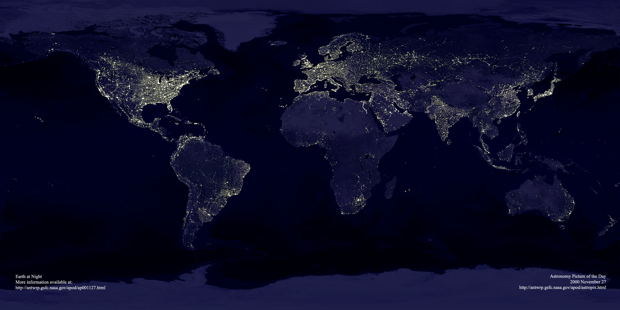
Re:how about high speed rail instead?
Thank you for saying this! I generally like using this image to refute similar claims about the relative lack of population density in the US, presuming that light intensity scales rather well with population in developed countries. I'll leave the calculation of the actual population densities as an exercise for the reader.
Yes, the population density of the US as a whole is lower than that of western Europe; however, the population density in the US within states east of the Mississipi River is comparable to much of Europe. Unfortunately, the mass transportation system connecting major population regions in the US is uniformly awful; to my mind, there is no justifiable reason for that.
-
Re:Most interesting part...
Last modified Mon, 1 Nov, 2010 at 14:42 Nowhere it says on that article, that it is deployed... http://www.nasa.gov/mission_pages/msl/news/msl20120817.html
-
Re:More important...
Um, what "research" have they actually done?
Hundreds of experiments listed here. I am not sure if these are ALL the experiments or just those conducted by NASA: http://www.nasa.gov/mission_pages/station/research/experiments/List.html
-
Re:context interpretation
Voyager's pictures are here:
http://voyager.jpl.nasa.gov/spacecraft/sceneearth.html -
Double transit
First, it's a double transit.
Second, check out this double transit here in our solar system.
-
can someone explain...
Can someone explain to me why "storing, retrieving, and analyzing molecular biology data" is considered to be its own field, where people actually get degrees specifically in bioinformatics, while storing, retrieving, and analyzing any other sort of data is just software engineering/computer science?
Not trying to troll or bait flames, I'm genuinely wondering if there's something I'm missing, or if there's just hype about "biochemistry, now with *computers*!" I've taken my plain vanilla CS degree to a wide array of fields including information security, space science, telephony, and e-commerce. What makes processing strings of ACTG different than processing other strings? Thanks.
-
Re:Ice "may" be there
The lower the orbit you put a spacecraft in around the moon, the more fuel you will need in order to continually correct for the moon's various mass concentrations (the moon is very lumpy). An orbiter just a few miles above the surface will need a LOT of fuel to keep it from crashing in to the moon's surface. A 1km orbit would be completely impracticable.
This NASA article explains the issue quite well.
-
RESOLVE Mission
NASA is working on it.
http://www.nasa.gov/exploration/systems/ground/resolverover.html
-
cannot do any space exploration?~!
>> you cannot do any space exploration because the US is spending huge amounts of money on the military
Seen any news about Mars lately? Thought so. Then also check out:
http://www.nasa.gov/missions/current/index.html -
Re:Bye Apple
They could have purchased TomTom, for example and had everything up and running immediately.
I think it's a bit more complicated than that. From Apple's mapping attribution page:
© 2006-2012 TomTom
Business listings data © Acxiom, 2012.
Map data © AND.
Property parcel data for USA. © CoreLogic Inc., 2012.
Satellite imagery data © DigitalGlobe, 2012.
Map and postal data © DMTI, 2012. This software contains Postal Code OM Data copied by Apple under a sub-license from DMTI Spatial Inc., a party directly licensed by Canada Post Corporation. The Canada Post Corporation file from which this data was copied is dated 2012.
Business listings data © Factual 2012.
Map data © Getchee, 2012.
© INCREMENT P CORP., 2012, http://www.incrementp.co.jp/gc01info/e/legal01.html.
Map data © Intermap, 2012.
Map data © LeadDog, 2012.
Business listings data © Localeze, 2012.
Mapping data for Australia and New Zealand. © MapData Services Pty Ltd., 2012, PSMA http://www.nowwhere.com.au/lic/NowWhereLic.htm.
Map data © MDA Information Systems, Inc., 2012.
Neighborhood data © Urban Mapping, 2012.
Map data © 2012 Waze.
âoeReviews from Yelpâ Yelp, 2012.
(CanVec)
© Department of Natural Resources Canada. All rights reserved.
http://www.geogratis.gc.ca/geogratis/en/index.html
(CGIAR-CSI SRTM)
CGIAR Consortium for Spatial Information, http://srtm.csi.cgiar.org/
Flickr Shapefiles Public Dataset, Version 1.0, http://www.flickr.com/
(GeoNames)
GeoNames and contributors, http://www.geonames.org.
(GlobCover)
© ESA 2010 and UCLouvain, http://www.esa.int/esaEO/index.html
National Aeronautics and Space Administration, http://www.nasa.gov
Contains Ordnance Survey data © Crown copyright and database right 2012. Contains Royal Mail data © Royal Mail copyright and database right 2012. http://www.ordnancesurvey.co.uk/oswebsite/
(OSDM)
© Commonwealth of Australia, 2012. This data has been used with the permission of the Commonwealth. The Commonwealth has not evaluated the data as altered and incorporated within this software, and therefore gives no warranty regarding its accuracy, completeness, currency or suitability for any particular purpose. http://spatial.gov.au
(OSM)
OpenStreetMap contributors, http://www.openstreetmap.org/
(StatCan)
Statistics Canada, http://www.statcan.gc.ca
(TIGER/Line® fi -
Re:Water, or some other fluid?
They didn't, they moved right along.
Well, a couple things to realize:
1) They certainly did get a ChemCam measurement of at least a couple of the sedimentary outcrops -- definitely the Goulburn Scour at the landing site, and probably the Link outcrop. In the Raw Image archive it shows shots from the Cam part of ChemCam around the time they would have been departing Link, and those are used for context of what ChemCam is shooting. They've been shooting quite a bit of things with the laser, since it's "cheap".
2) ChemCam isn't designed to find organics -- it does elemental spectroscopy, and any organics would be destroyed by the laser. And it's really best for giving you an idea of the predominant elements in a sample. John Grotzinger called it "qualitative", at least in comparison to the other instruments. Previous measurements of Goulburn showed composition consistent with the Martian basalt they see everywhere. So ChemCam measurements really don't add anything to the conclusion that water formed these sediments.
To really determine if there are organics in the soil, they'll need SAM and Chemin. Those will come into play once they start using Curiosity's sample collection capabilities, which will be exercised soon at Glenelg (possibly before, but definitely during the months at Glenelg).
-
Re:Dark side of the moon...
The definition of "dark side = the side that does not receive signals directly from earth" sounds to me as simply tailored to give a plausible explanation to the incorrect usage of the term... Of course the wikipedia article is useless...
How about NASA? Is that an official and scientific enough source for you?
1) Here's the definition of "Darkside Of The Moon" provided by the High Energy Astrophysics Science Archive Research Center arm of NASA.
2) Fourth paragraph, 2nd sentence to the end (better yet, search for it.), in this educational material for young children provided by NASA.
3) From a 2010 open "Ask an Expert" chat session: "There's really no dark side of the moon, it's just the side we never see." Even when 'debunking' the term they define it as "the side we never see".
I suspect the (incorrect) usage of the term "dark side" might be older than radio signals.
I think it odd that while you claim someone else is redefining the term, you also acknowledge the historical meaning IS exactly what they claimed it to be.
And since (as we both agree it is) the traditional meaning of the "dark side of the moon" is "the side of the moon we never see", that makes "the nightside" the actual redefinition of "the dark side of the moon".
BTW, that Fox News said something does not make it false. Just highly unlikely! ^_^
-
Re:What are the military applications?
This is the best reply I've read here. I think that back when they built the current system (article says 1961) the military wanted to know where everything was so they could identify the military threats. (You also don't want to launch your counter-strike when that Russian rocket booster burns up over Alaska.) That's still the case, but the use for collision avoidance is becoming more important now. The data go into real-time calculations and also into long-term environmental models.
The data (sure...minus classified) are already available to the public, with the caveat that these are averaged/low-res data not suitable for collision avoidance. -
Hubble Ultra Deep Field
Personally I prefer the 2004 Hubble Ultra Deep Field
http://apod.nasa.gov/apod/ap040309.html
Warmer picture (it's been my desktop background for the past 8 years), and the contrast and detail seem to be better (compare closer spiral galaxies) than the Extreme Deep Field. Lower noise as well.
The "exposure" time and sensitivity and science of the Extreme is impressive, but for viewing pleasure I'll take the HUDF.
-
Re:image size
There is a 13Mb TIFF you can download.
I assume the image is the size it is because while the source images were wider, http://www.nasa.gov/mission_pages/hubble/servicing/SM4/main/WFC3_FS_HTML.html mentions a 4096 x 4096 sensor, but after stacking, the 2382 x 2078 are the common pixels to all images. Each image may include extra data that does not overlap with all the other images, so it is cropped.
-
Re:Hard to imagine the vastness
3) the fact that they held the camera that steady for 2 million seconds (23 days)
They didn't. This image is the result of combining exposures of the same region taken over the last ten years. Skip the article linked in the summary and go straight to the source for the details: Hubble Goes to the eXtreme
-
So much in so little sky...
NASA's page about the eXtreme Deep Field has a picture showing the amount of sky photographed compared to the size of the moon. It looks like all 5500 galaxies could be covered up by a grain of sand held out at arms length.
-
Re:How does something so un-dense...
Chandra isn't seeing X-ray emissions from the gas, it's seeing X-rays being absorbed by the gas. Specifically, observing 8 X-ray sources hundreds of millions of light-years beyond the gas, it was discovered that some of the X-rays from those sources were being absorbed, and it was possible to deduce the temperature of the absorbing gas.
Whoops. My bad, But my point still stands: the light is being absorbed by oxygen ions at a temperature of a million Kelvin: what do you think is ionizing them?
When people refer to temperatures in a galactic halo, they absolutely mean to imply that the halo is somewhere close to thermal equilibrium. -
Those robotic arms...
... are Canadian. But of course, you knew that.
-
Re:meanwhile....
Skepticalscience, a fringe website run by a complete nutcase, is often wrong. As it is in this case.
http://ntrs.nasa.gov/archive/nasa/casi.ntrs.nasa.gov/20120013495_2012013235.pdf
-
NASA!
I can't believe no one has mentioned it yet but space exploration is still pretty awesome. Donate the money to NASA!
-
NASA!
I can't believe no one has mentioned it yet but space exploration is still pretty awesome. Donate the money to NASA!
-
Re:Show me the calculations
You can't really expect the math to be on Discovery.com. It's a general interest site for the public. It needs to be accessible (though perhaps it wouldn't hurt them to link to it...).
Someone else posted the original paper, which can be found here.
-
Original paper
-
Re:Eclipses viewed from MER
Every location on Mars gets an eclipse by both Phobos and Deimos twice a year.
No, only at the equator
There is a narrow band, centered on the equator of Mars, within which every point is eclipsed at least once during each semiannual eclipse season. Outside that band, the density of coverage decreases slowly with increasing distance from the equator, until the limiting latitudes are reached.
BTW, a surface transit (that is a more appropriate proper term, as neither moon ever fully eclipses the Sun) was also observed by the VIking Lande 1 in the 1970's.
And for the Earth solar eclipses, over an 18.6 year cycle, are equally likely in either terrestrial hemisphere.
-
Not new with DARPA
I'm surprised that DARPA is getting all the credit here; the approach isn't new with DARPA.
That approach is known as the "spectrum splitting" approach. Some older work was the NASA "rainbow concentrator" array concept:
http://ntrs.nasa.gov/search.jsp?R=20110024141
http://www.techbriefs.com/index.php?option=com_staticxt&staticfile=/Briefs/June03/NPO21051.htmlIn general, spectral-splitting concepts do need to track the sun, and so they're envisioned more for concentrator systems than for flat-plate arrays.
-
Re:Glenelg?
"Glenelg [goo.gl] is a suburb (and rather nice beach) in Adelaide, South Australia. As far as my Google-fu can determine, it is the only location named as such on earth."
No, there are more. The original Glenelg is a village in Scotland, after which the suburb in Australia is probably also named.
Generally speaking, the MSL team make up a list of names from a particular region or theme, and then they pick from those as they go along. This was the case for the previous rover missions too.
The current theme for the names is based on names of features near Yellowknife in northern Canada. Glenelg is one of them (presumably itself named after the original Glenelg in Scotland). A lot more details about the choice of MSL names and about Glenelg here.
-
Re:The video is of aeroshell's decent, not Curiost
That's the heat shield dropping away at the start. The video was taken by Mars Descent Imager that was on the bottom of Curiosity. http://msl-scicorner.jpl.nasa.gov/Instruments/MARDI/ The title is accurate.
-
Re:Ah, Ye Olden Times.
Would it make you feel better to know that Sojourner from the Pathfinder mission tried to return to it's base station after we lost contact with it?
http://www.nasa.gov/mission_pages/MRO/news/mro-20070111_prt.htmWait, no? Why are you sobbing?