 Slashdot Mirror
Domain: noaa.gov
Stories and comments across the archive that link to noaa.gov.
Stories · 160
-
Rare South Atlantic Hurricane Heads Toward Brazil
jellisky writes "An unprecendented sort of weather event has been occuring recently, without much fanfare at all. A tropical cyclone in the south Atlantic is slowly drifting toward Brazil. The southern Atlantic ocean isn't exactly a hurricane hotbed, as pointed out by National Hurricane Center forecaster Jack Beven, "We know there hasn't been a hurricane in that area since at least the satellite era, the mid-60s at the minimum." The storm is a small one, though, but has estimated winds near minimal hurricane strength (74-95 mph). It's quite an interesting sight, perfect for piquing the weather curiousity that many of us have." -
Perfect Weather on the Net
ctwxman writes "Here in the East, we're having a heck of a weekend. The snow has been flying, accompanied by wind, accompanied by people on TV saying, 'stay home.' I'm one of those people. I forecast the weather for a living. It's a great job... a magnificent physics puzzle, solvable with high level math and some acquired skill. And, there's a new puzzle every day, tenuously linked to the one you solved yesterday. When I started doing this over 20 years ago, the data to accomplish the task was tough to come by. I remember how excited I got when I first was able to get data at 300 baud on a request/reply basis (I guess we call that interactive now). Now, nearly everything you need to forecast the weather is here, on the net. Yes, there are a zillion sites that already have the finished forecast, but this is Slashdot. We don't need no stinkin' forecasters!" Read on for ctwxman's notes on do-it-yourself weather forecasting.ctwxman continues:
I always like to start at NCEP (National Centers for Environmental Prediction) for a look at the dynamic models. Each is run using somewhat different equations, making them often come up with different, quite contrary solutions. Some of these models, like the GFS are worldwide in their coverage and forecast out an amazing 16 days (note: the word accurately was not used in the last sentence). Once the dynamic models are through, we can massage them against past performance under similar circumstances at specific places. These are the statistical models, referred to as MOS (Model Output Statistic) models. Again, there are somewhat different solutions from different models. If none of these work for you, run your own. There are programs available to allow you to run your own model, specifying the domain, grid spacing, time interval, etc. The most commonly used research model of this type is the MM5, produced at Penn State University. Run it on your PC! Of course, it's freely available and supported. Sometimes, the data you want already exists, but not in the form you'd like to see it. That's where software like GrADS comes in. Put out by the Institute of Global Atmosphere and Society's Center for Ocean-Land-Atmosphere Studies, GrADS claims to be an 'interactive desktop tool that is used for easy access, manipulation, and visualization of earth science data.' I agree with all except 'easy.' I run a version of GrADS on my server in order to produce localized forecast graphics like this that wouldn't otherwise be available. Yes, looking at satellite imagery and radar is a lot of fun... but the real fun is knowing what will be there before you look. And, astoundingly enough, we are significantly more accurate (and I get assaulted significantly less often at the grocery store) than even a few years ago. -
Sun Produces Strongest Flare Ever Recorded
idontneedanickname writes "The BBC is reporting about the newest flare unleashed by the sun. According to NASA's SOHO website, "Today word came from the SEC that their best estimate was X28. We have a new number 1 X-ray flare for the record books." As usual there are magnificent images to be admired." This one's not headed straight for us... -
X17 Solar Flare Sends 2B Tons of Plasma at Earth
Dr. Zowie writes "This morning a very large solar flare erupted from a large sunspot group that is crossing the face of the Sun. The explosion sent over 2 billion tons of material hurtling across the solar system toward Earth. Movies from the SOHO spacecraft show the flare in UV and the associated coronal mass ejection in visible light as they happened, and the impact of high energy protons that the flare launched at about half the speed of light. NOAA's Space Environment Center shows that the Sun's X-ray brightness went up 100x during the flare. Expect more aurora and geomagnetic effects in the next day or two!" -
The Impact of Hurricane Isabel Shown Through LiDAR
whitefox writes "The folks at NASA, USGS, & NOAA flew flights gathering elevation data (including building tops) along the Outer Banks before and after Hurricane Isabel as part of the Eastern Coastal & Watershed Studies on hurricane and severe storm impacts. The preliminary results have been put out on a temporary website. I certainly don't make light of the suffering many people went through, including my own relatives, but I'm utterly awed by these pictures." -
Workweek Causes Climate Changes
Shipud writes "An article in the Proceedings of the National Academy of Sciences reports that daily temperature ranges are smaller on weekdays than on weekends. This phenomenon is strongest in the US, but also appears in China and Japan. The researchers attribute this to human activity, although the exact mechanism is unclear. The prime suspect is aerosol / cloud interactions. Here is the more legible version from Scientific American" -
Satellite Views Of The Blackout
An anonymous reader writes "These Before and After satellite views of the blackout, from the NOAA, show the geographic extent and intensity of the outage. Toronto, Ottawa, and Detroit seem the worst hit. Currently, a cnn article mentions that a reverse of power flow around Lake Erie may have caused an overload that triggered the programmed shutdown of the power grid. Would be interesting to know how the system and software works, but then again, that information could be dangerous in the wrong hands." -
New Underwater Volcano
fuqqer writes "CNN has a story about a new volcano just a few hundred feet below the ocean's surface. It is just off of Alaska's Aleutian Islands. Soon we all might be able to walk to Russia during the summer! Here's a cool link to the Alaska Volcano Observatory with satellite pictures of Alaska Volcanos. Here's a link to the NOAA's underwater features site." -
Which Red Hat Should Be Worn in the Enterprise?
weatherbug asks: "I've recently been appointed as a member of a team to help determine the direction our organization is headed with Red Hat Linux. Currently we're using multiple versions from Red Hat 6.x through Advance Server 2.1. However, now that Red Hat has effectively separated their distributions into a 'consumer' (Red Hat 8,9, etc) and 'enterprise' (Red Hat Adv. Server 2.x, etc), we aren't sure which version we want to adopt. A Red Hat salesman recently told us that the 'consumer' version of Red Hat was mostly for hackers and hobbyists who weren't concerned about stability and wanted the most up-to-date software, while the 'enterprise' version would be more stable and have a five-year product lifetime. As a long time Linux system administrator, I feel that this is a sales tactic and that there really is no compelling reason for us to ever use the 'enterprise' version. After all, it is Linux and it is open source, and we have enough in-house talent to not need Red Hat support. Why would we ever need or care about a five-year product lifetime? Am I wrong, and if so, could you set us straight? We'd be interested to know what other large organizations have decided to do." -
E.U. Agrees To Launch Galileo Satellite Location System
waimate writes "The European Union today decided to go ahead with Galileo, the constellation of 30 satellites which will compete with the U.S. GPS system. The U.S. abolished selective availability three years ago partly to make GPS more useful for all mankind, but also to dissuade other countries from developing their own navigational satellite system, and thus be dependant on the U.S. for both peaceful and military purposes. Since the demise of the Russian GLONASS system, GPS is the only game in town. Evidently recent events make Europe feel less comfortable about such things, and so they're building their own. Good thing for commercialization of space, or bad thing for world peace?" -
Surviving Tornadoes
SharkJumper writes "We here in central Oklahoma, USA are just climbing out of the wreckage of another series of tornadoes. Unlike the tornadoes of May 3rd, 1999, which killed 47 and injured more than 800, we now have much better tornado information and prediction technology. Largely because of this, there have been far fewer injuries, and (as of this morning) no reported deaths. Here in the greater Oklahoma City area, we can even register our storm shelters with the city. After a severe storm, GIS technology is used to create a map for rescuers detailing location and type of the shelter as well as emergency contact information. Rescuers can then use these maps to search for survivors that may be trapped by debris in their shelters." -
Using Commoditized Computers Setups for Stock Trading?
An anonymous reader asks: "Thanks to Walmart, TigerDirect, and Gnu/Linux, I can get computers at about $200 now. Thanks to Matrox, I have several multi-head video cards. Thanks to a hacker's convention last year, I have a truckload of monitors that haven't been put to use yet. I've been out of the financial markets since 1996. I'm itching to get back in now, especially since conditions will be very favorable shortly. Since I've lost my shirt in the markets already (most investors/traders loose their shirts at least once before striking it rich, and my beating was especially instructive), I'm now ready for better returns. Gnu/Linux is well known to support multiple monitor setups. I've seen 4 monitor setups per box in some financial firms, and I recently read a story on the National Weather Service using 3 monitor setups on another OSDN channel. I've also used a Quotrek trading monitor in the past, for monitoring stocks and other financials in real-time. This was before I was a penguinista. Now that I know a bit about Linux systems, I'd like to know the following: What Gnu/Linux applications can I use to monitor and/or process stocks, options, bonds, financial news, and other related information via low cost Gnu/Linux computing solutions, broadband, and multi-head video cards? Free software only, please""I'm not going back to paying hundreds of dollars per month like I did for my Quotrek (an FM receiver for stock quotes, possibly discontinued), or paying many hundreds for proprietary software that may not get the job done, or can't be modified or supported by the community. What free software applications do you use? What is a good multi-monitor layout? Any free software that picks up financial broadcast signals and decodes to a computer screen? Any slashdot tycoons want to help out other Slashdot readers?"
-
Globe Warmer In Time of Vikings
SEWilco writes "A record of recent global temperatures has been assembled by piecing together the hundreds of studies with past temperature estimates [Discovery, Harvard]. The record shows there was a "Medieval Warm Period" warmer than the 20th Century. This was followed by the "Little Ice Age", which ended around 1900. We're having average climate now. Numerous sources indicated this, but apparently were not gathered into one document" This adds some more background reading to the previously linked Telegraph story. -
New Service from NOAA - Real-Time Solar Imaging
InfoSec writes "I was checking out the National Weather Service in the US earlier and I noticed a new feature added to their site.... Near real-time solar imaging!!! The images are VERY kewl. Does this mean that we'll soon be predicting solar events?" -
NOAA Identifies Mystery Noise as Minke Whale
Anonymous Cowherd writes "An underwater noise that has long confounded Navy sonar operators turned out to be a call of the minke whale, the Sacramento Bee reports. Scientists at the Southwest Fisheries Science Center in San Diego made the discovery this fall when they heard the noise during a research expedition and saw a minke whale surfacing. While the story mentions minkes in the North Pacific, here's a sample from an Atlantic minke." -
Linux Clusters Finally Break the TeraFLOP barrier
cworley submitted - several times - this well-linked submission about a slightly boring topic - fast computers. "Top500.org has just released its latest list of the world's fastest supercomputers (updated twice yearly). For the first time, Linux Beowulf clusters have joined the teraFLOP club, with six new clusters breaking the teraFLOP barrier. Two Linux clusters now rank in the Top 10: Lawrence Livermore's "MCR" (built by Linux NetworX ) ranks #5 achieving 5.694 teraFLOP/s, and Forecast Systems Laboratory's "Jet" (built by HPTi) ranks #8 reaching 3.337 TeraFLOP/s. Other Linux clusters surpassing the teraFLOP/s barrier include: LSU's "SuperMike" at #17 (from Atipa ), the University at Buffalo at #22 and Sandia National Lab at #32 (both from Dell ), an Itanium cluster for British Petroleum Houston at #42 (from HP ), and Argonne National Labs at #46 (from Linux NetworX ) reached just over the one teraFLOP/s mark with 361 processors. In the previous Top500 list compiled last June, the fastest Intel based Netfinity 1024 processor clusters from IBM were sub-teraFLOP/s and the University of Heidelberg's AMD based "HELICS" cluster (built by Megware ) held the top tux rank at #35 with 825 GFLOP/s." -
Inside the Radar, Satellite and Wind Vectors of a Storm
ThOr101 writes: "While searching for radar scans of the next front to pass through the DC area, I found Meteorologist Dr. Stephen Jascourt's play by play of the weather leading up to the La Plata, MD tornado. He has taken the Satellite, Radar, and Wind Vector image loops from the time period and annotated with his comments describing the storm. As a member of Sky Warn, and just a weather nut, this was a great opportunity to see what the Storm Prediction Center, as well as the Local National Weather Service offices might look for when sounding a Watch or Warning." -
Penguins Invade the North Pole
An Anonymous Coward writes "Thanks to a project of the U.S. National Oceanic & Atmospheric Administration (NOAA), a webcam has for the first time been installed at the North Pole -- one which runs on Embedded Linux (uClinux), no less! The device was installed on April 28, 2002 and is now logging four images a day, which are available for viewing on NOAA's publicly accessible website. This article at LinuxDevices.com describes the Linux-based webcam (called the NetCam), opens up the device to see what embedded hardware and software are inside, and explains why the NetCam's developers used Embedded Linux as the basis of their design." -
Huge Iceberg Nine Times As Large As Singapore
DeadBugs writes: "From CNN and the actual National Ice Center press release, a huge iceberg 2130 square miles in size has broke off of Antartica. Satellite pictures are included at each site. This iceberg is larger than the state of Rhode Island and about the same size as Delaware." -
Weather Balloons as Wireless Telephone Technology
Under the plan described in this article submitted by reader RoscoHead, "Space Data would use un-tethered weather balloons launched daily by the National Weather Service to carry lightweight wireless communications equipment to an altitude of 100,000 feet. There, at the 'SkySite,' they would relay voice and data signals to remote areas at a fraction of the cost of installing cell towers or launching satellites, company officials say." -
The Coldest March
Stalwart reviewer Duncan Lawie contributed this review of Susan Solomon's The Coldest March, the epic tale of an early and tragic polar expedition, not long after returning from an Antarctic trip of his own. (Imagine spending New Year's en route to the southern ice.) Duncan's been cooking up some other things lately, too -- like an interview with Science Fiction writer Ken Macleod and a review of the LotR movie from a "bookist" perspective. The Coldest March: Scott's Fatal Antarctic Expedition author Susan Solomon pages ~400 publisher Yale University Press (Australasia: Melbourne University Press) rating 8.5 reviewer Duncan Lawie ISBN 0-300-08967-8 summary "Cold equations" throw a new light on significant events of the Heroic Age of Antarctic exploration. Susan Solomon is a senior scientist at NOAA , and an acclaimed one. In 1986 she led a scientific expedition to Antarctica to investigate the causes of the ozone hole; she subsequently received the USA's National Medal of Science for her insights. Whilst working from such locations as McMurdo Station, Solomon had the opportunity to see the bases and places discovered in the early years of the twentieth century. This led her to a new "hobby." Solomon became interested in the history of Antarctic exploration and in the disjunction between the common belief in Scott's incompetence and the apparent perceptiveness of his and his party's own writing. As an atmospheric scientist, Solomon decided to embark upon the exercise of tracking down the weather data of the era and testing it against data subsequently collected.The Coldest March is the outcome of Solomon's interest in her hobby. It is, in essence, a history of Captain Scott's voyages to the Antarctic, a story which has been told many times in the decades since Scott's death. Yet, never before has the history been focused through the lens of true science. Science was held in high esteem by these Edwardian explorers and is the continuing basis for human occupation of the Antarctic. Solomon's close attention to the meteorological record becomes genuinely interesting as it is possible to make an intelligent comparison between the historical data and the automated data collection of recent decades. The modern route to the Pole from McMurdo Sound is close to that used by the British explorers 90 to 100 years ago. Whilst few attempt the journey on the ground, automated weather stations are vital for US Antarctic Research Program flights in the region. This data, collected every ten minutes since 1984, provides a statistically significant basis for investigation.
The technical substance of what Solomon has to say in this book first reached publication in the Proceedings of the National Academy of Sciences, in a paper co-authored with Charles R. Stearns. Those few dense pages form a scientific data quality check and comparison, with the conclusion that the March of 1912 was significantly colder than the average, that Scott's weather forecasters had collected sufficient data to have a good idea of what that average was and that the unexpected cold was a primary factor in the deaths of the party returning from the Pole. These cold facts have been expanded into a solidly researched history of Scott's Antarctic career, with a strong focus on the collection and interpretation of weather data.
The basic point of this book should prove within the grasp of anyone capable of interpreting a graph. The historical issues, however, require a larger context. The book approaches the debate on Scott through the clever technique of "the visitor". At the start of each chapter, there is a vignette offering a view of the modern Antarctic experience which parallels the main subject of the chapter. In this space, Solomon can provide informal commentary and bind the historical discussion with description of the achievements and misunderstandings that are still possible after over 40 years of continuous human occupation of the continent. The visitor provides an access for the modern reader to a well known story. Scott's Pole party arrived at the South Pole in January 1912, five weeks after Amundsen. He and his four companions died on the return journey, Scott, Wilson and Bowers only 11 miles from a supply depot. At the time this tragedy quickly became a heroic example; some modern writers have considered Scott's whole Antarctic experience closer to farce. The heritage of the expedition often turns on the perceived reputation of Scott himself; this book reflects positively on Scott and his colleagues, principally because of the primacy of doing good science in their work. Nevertheless, it acknowledges the mistakes made by both Scott and his rival and recognises the strengths of each party. It is a decent account of the so-called "Race to the Pole", providing a setting in which the relevance of the weather thesis to Scott's death can be fully developed and strongly argued. By dredging bare facts to the surface, The Coldest March has rendered almost every published history of the period out of date.
Each generation seems to find its own vision of Scott. Solomon sees him as a frustrated scientist and, at its centre, this book is a celebration of scientific method. It is tempting to think that the author has seen most strongly the elements of Scott that a modern scientific mindset might wish to find -- as earlier generations have praised him as a heroic exemplar of the British Empire or damned him as a middle class bumbler. Countering this are the words of members of Scott's own scientific party, many of whom relished his ability to ask the right question. Coming from such an original perspective, and providing genuinely new information, this is as significant a book as Apsley Cherry-Garrard's The Worst Journey in the World, published 80 years ago. The Coldest March is a wonderful (re-)introduction to the Matter of Scott.
You can The Coldest March at Fatbrain. If this review interests you, perhaps you'll enjoy the Coldest March website. More information, incuding sample chapters from the book, are available at Yale University Press. -
233 sq. mile Iceberg
Nevyan sends in a link about a substantial iceberg breaking free of the Antarctic ice. -
Antarctic Ozone Hole Leveling Off
twistedfuck writes: "An Irish Time article reports that the size of the hole in the antartican ozone layer is levelling off and should begin reducing in size. It seems like it should be welcome news but it is tempered by the fact that more UV radiation will reach the southern hemisphere this year because the hole will persist longer. Unfortunately I can not find any details regarding the NOAA report on their website." Update: 11/06 17:31 GMT by H :Thanks to Isaac Lewis, NOAA Sysadmin and Slashdot reader, for pointing out more information, as well as pointing out the ozonelayer site. -
Northern Lights Not So Northern
Several readers have written with news of an unusual display of the Aurora Borealis, among them Georgie Porgie, who writes: "Crawl away from those terminals and step out side for a view of the norther lights... I am in Columbia, Missouri, USA Approx 39.9 N latitude and I am looking at the northern lights... Hope the networks are up tommorow... See what causes the lights at http://www.spaceweather.com/" fjordboy points to this excellent noaa.gov link, too. -
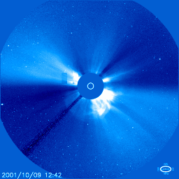
Aurora Alert During The Nights Ahead
Jens Lönn writes: "Magnetic fields above sunspot 9653 erupted yesterday (Oct. 9th at 1110 UT) and hurled a full-halo coronal mass ejection toward Earth. The expanding cloud, which speed away from the Sun traveling approximately 1000 km/s, could strike our planet's magnetosphere as soon as Thursday, Oct. 11th. Sky watchers, especially those living above geomagnetic latitude 50 degrees, should remain alert for Northern Lights during the nights ahead. The best time to spot auroras is usually around local midnight. Note: This is not an alert for a geomagnetic storm, it's just an alert for those who wants to watch great auroras at night." -
Flare Sends A Gigaton Of Solar Detritus Toward Earth
Dr. Zowie writes: "This morning at about 10:00 UT, a major explosion occured on the Sun. The solar X-ray output went up by over 1,000 times. About a billion tons of material are speeding toward Earth at over a million miles per hour, and should hit sometime in the next couple of days. Low latitude aurorae and anomalies in radio communications and power service are likely consequences. You can see the event from the SOHO spacecraft's home page -- images and movies are here. In the movies, watch for the burst of radiation hitting SOHO about 13:00 UT -- that's a high energy proton storm caused by the flare itself. You can also see the earthly effects of a similar event from last year." -
EMWIN Software for Linux?
Chanc_Gorkon asks: "anyone know of any EMWIN software for Linux? EMWIN stands for Emergency Managers Weather Information Network. Weathernode is a free as in beer client for windows that can accept this info. EMWIN will pick up National Weather Service alerts usually before the TV and Radio people say anything. I searched both Freshmeat and Google and saw nothing but maybe embryonic projects, not ready even for developer consumption. Further info can be found at the NWS's EMWIN page. It seems, to me, that this would be a nice thing to have on Linux since Weathernode eats resources. This program even can retreive NEXRAD images and animate them.""One can access this network from a satellite feed using equipment similar to DSS equipment (GOES 8 and 9 transmit this info), via rebroadcast if your locality or local amateur radio rebroadcasts the signal (can be picked up with scanner, and you can feed this thru a TNC, or a soundcard input) or the Internet. "
-
Sunspots
jerkface writes: "The biggest sunspot in 10 years has released an outburst of solar matter that will likely reach Earth on Friday, according to the National Oceanographic and Atmospheric Administration (NOAA). See space.com or the NOAA. There is a chance this will lead to a geomagnetic storm Friday or early Saturday." The standard sysadmin response for what caused a computer problem is actually valid now. -
Piezoelectric Generators
Teahouse writes: "The U.S. Navy has developed this polymer "eel" that they dump in the water and get a trickle charge back. The biggest application for this would be for deep sea bouys that track weather across the pacific. This could extend accuracy, and lifespans...and save a few lives along the way. Here is the story." NOAA uses buoys that are solar powered and are left out for a year or more at a time, but I imagine that if this worked they'd be interested, too. -
Geomagnetic Storm To Begin Tonight
Kiel Oleson writes: "According to the Kansas City Star and the Space Environment Center, there is an 80% chance that a series of five geomagnetic storms will disrupt communications and power systems. These storms will hit the earth beginning at 5 PM CST today and ending at 5 PM CST tommorow. There is a 40% chance of there being severe or major disruptions in satellite orbits, electrical grids, and radio. The good side? Some of us may be able to see the Aurora! Get those UPS's charged!" Everyone's cell phone working OK? -
Near-Perfect Storms Hits Antarctic Icebergs
Joe writes "A unique, July 20th, satellite "photo" of a near-perfect, tightly-wound, hurricane-like storm in Antarctica (now in the throes of a typical, bitterly cold, austral winter with temps sometimes ranging below -90 F., or -68 C.) can be seen here. The storm is seen in the image near two huge icebergs, B-15A and B-15B, that had calved from the Ross Ice Shelf in March as parts of one monster iceberg, B-15 (186 miles long and 23 miles wide, or 4200 square miles; it's about 2% of the entire area of the Ross Ice Shelf, the largest ice shelf in the world). Iceberg B-15 is also the largest ever recorded in the 24-year database of icebergs maintained at the National Ice Center. (Members of the Coriolis fan club will also happily note the storm's clockwise circulation, the common characteristic of storms in the Southern Hemisphere). It should be interesting to see what effect the storm will have on the positions of these two huge icebergs. N. B., Three other huge icebergs, A-43A, A-43B, and A-44, totaling about 4000 square miles in area, calved from the Ronne Ice Shelf (second largest in the world) in May. They were not near the storm on July 20. It's not just Greenland's ice that's disappearing!" I'm afraid that I lack the background to really understand what's going on here, but a link to the "National Ice Center" was too much to pass up. Betcha didn't even know the U.S. had a National Ice Center, did you. Are these photos interesting because a) the ice cap is melting, b) these huge icebergs are going to wander into shipping lanes, c) they're just so damn big, or d) some other reason? -
Another Solar Storm Approaching
RZG writes: "Aurora might be visible again across the mid-latitude portions of the U.S. and Europe, thanks to the CMEs (coronal mass ejections) associated with two powerful X class solar flares, and some smaller flares. The activity may begin in the next few hours, and last up to several days. The NOAA predicts another G3 class storm. Watch Spaceweather.com, the NOAA's space weather forcast, or this solar activity report for more information. The geomagnetic storm could cause power and satellite failures." -
Another Solar Storm Approaching
RZG writes: "Aurora might be visible again across the mid-latitude portions of the U.S. and Europe, thanks to the CMEs (coronal mass ejections) associated with two powerful X class solar flares, and some smaller flares. The activity may begin in the next few hours, and last up to several days. The NOAA predicts another G3 class storm. Watch Spaceweather.com, the NOAA's space weather forcast, or this solar activity report for more information. The geomagnetic storm could cause power and satellite failures."