 Slashdot Mirror
Domain: noaa.gov
Stories and comments across the archive that link to noaa.gov.
Comments · 2,602
-
Re:weather radar image
Not sure of it's been posted by anyone on the two threads, but here's a Radar Image of the debris rain being picked up by weather stations.
That image is labeled "15:26 UTC 02/01/2003". If I'm doing the math right (and Texas is on Central Standard Time, a.k.a. UTC -6:00), that's 9:26 local time, 10:26 Eastern
This Slashdot article from this morning points to this dramatic page, which shows a similar radar map, archived from about 13:00 to 17:00 UTC. The trail appears at 14:05 UTC, shortly after the breakup, and lingers for the remaining two hours of the loop. (The original poster said it "disappears so suddenly," but I think it's just the end of the loop.) I hacked the URL a little, and watched it last until almost 21:00 UTC, nearly seven hours after the incident.
So what is it? A line of dust-sized particles too light to fall? Some sort of condensation or thermal effect? (There are some other line-shaped artifacts in some frames, but nothing so dramatic.)
Nothing shows up in the live radar map.
P.S.: The ucar.edu page just stopped responding. Slashdot effect? -
Re:NOAA Radar (Working Link)
Use this link instead
http://www.srh.noaa.gov/radar/latest/DS.p19r0/si.k shv.shtml
(you just had a random space in your URL) -
radar image
-
Radar image of the breakup
This is an interesting radar image showing the scale of the breakup that illustrates quite why wreckage has been found over an area of hundreds of miles.
-
Re:NOAA Radar
Here's a better shot from Shreveport...
And potential government conspiracy?
Short range composite reflectivity from Shreveport
-
Re:NOAA Radar
Here's a better shot from Shreveport...
And potential government conspiracy?
Short range composite reflectivity from Shreveport
-
Re:Radar Pictures...
Sorry, I meant at http://www.srh.noaa.gov/radar/latest/DS.p19r0/si.
k poe.shtml -
Re:NOAA Radar
look at this still shot further along the trajectory..
-
NOAA Radar
NOAA weather radar / short range reflectivity for Mid-Texas shows a line of high return paralleling and just south of a line between Dallas and Tyler. It's time lapse. Quite a remarkable radar image.
-
Radar LinkTo give you a sense of the area here is some of the debris line on radar.
-
Re:Earth is mostly ocean
It looks to me like about half of the ocean floor is too young to have dinosaur fossils.But that is still a lot of territory.
Most of the old stuff looks pretty deep.
Given the typical paleontologist's budget, it is easy to see why they pick places like Montana and the Gobi Desert over the deep ocean. -
Re:OS X...
Excellent point. I can tell you that there's a lot of little insignificant looking crap that various government agencies cannot do without. Electronic SF-86's (security clearance paperwork), rare oddball little supply utils, etc., etc. In all fairness to NASA, I remember reading on
-
Re:Regression.
Well, these guys are ready.
-
Re:good thing
Abuse of apostrophes bother me too, but the example you're pointing to can be right or wrong, IMHO. As stated here, it can be used "to form a plural where the omission of the apostrophe would cause confusion."
Obviously, in this case, omission of it probably wouldn't cause confusion, but I would think that using apostrophes on acronyms would be correct? I could be wrong. ^_^ -
Chemosynthesis resources
-
Re:screwing with weather?
The quoted article is tame in comparison to what happened in Rapid City, SD in 1972. Cloud seeding was also suspected. The following link describes the flood and the 238 deaths:
www.crh.noaa.gov/
This link tells a bit more on the cloud seeding:
news.mpr.org/
Another article
starryskies.com
The cloud seeding wasn't proven, as it wasn't in many other cases, but public pressured forced SDSM&T to stop doing the experiments all the same. -
Rapid City 1972
-
NIMA and NOAA too
NOAA provides Bathymetry data and electronic navigation charts (vectorized) and NIMA (that's right,
ENJOY!
-
NIMA and NOAA too
NOAA provides Bathymetry data and electronic navigation charts (vectorized) and NIMA (that's right,
ENJOY!
-
Re:this will be great..
Average ocean depth = 12,566 feet. 1/1,000,00 * 1/100 * 12,566 feet = 0.00150792 inches, or 36 micrometers.
A few feet would be a few tenths of a percent, not millionths. -
Re:icebergsJust to go along with the above, here's a good page with links to a lot of the satellite imagery of icebergs in the north.
The Canadian Department of Environment also has regular updates and warnings about icebergs and the like. Presumably were the northwest passage to open up they'd track it. (I admit I'm a bit leery of trusting the prediction - but who knows) I suspect that, baring continued war in the mid-east, the United States military would be involved as well. Admittedly it is less of an issue now that the cold war is over. But they have had quite a bit of monitoring of the arctic sea in the past.
-
Re:PredictabilityFlares are not "predicted" easily. The physics is not well understood, and the observational resolution (e.g., from magnetographs) is not good enough to predict well where or when a flare will pop up. In any event, geomagnetic storms are not caused by flares but mostly by Coronal Mass Ejections (CMEs) that hit the Earth. Some flares result in CMEs and some do not. The CMEs that affect us are the ones that hit us, but not all CMEs hit us. Spacecraft like SOHO might see a flare eruption, but they cannot reliably tell if the CME is heading towards or away from Earth. The best candidates seem to be what they call "halo events." One of the big problems with CMEs is that they are very hard to detect because the amount of light they give off is millions of times less intense than then background light from the Sun.
We also get hit by CMEs that are caused by "backside events," which are flares or other disturbances that erupt behind the limb of the Sun and we didn't see them occur. STEREO is supposed to help there.
One researcher in the field of solar weather forecasting put the maturity level of space weather forecasting 50 years behind that of terrestrial weather forecasting. That was the state in 2000 and not much has improved since. The biggest difference is that for Earth weather forecasting we have continuous global weather observations on both the ground and from space. There is only a tiny fraction of coverage for space weather, and as I mentioned in my first post it still isn't clear what kinds of instruments are sufficient.
Good information resources on space weather can be found at the Space Environment Center at NOAA's web site. They have a nice education page on space weather. For a look into what the space weather field priorities are, one place to start is the Living With A Star program page.
-
Re:Space Weather
-
Re:Space Weather
-
Re:The Club of Rome
The relationship between greenhouse gases and global temperature is only well "known" among the environmentalist extreemists and the uninformed. Nobody is claiming that CO2 levels are decreasing in the atmosphere, but there is no evidence scientific or otherwise that can conclusively link a rise in C02 to a rise in global temperature.
Actually, it's well known to the informed as well. As I've stated before, global warming is supported by the vast majority of the worlds climate scientists.
Yes, global surface temperatures rose an average of 0.053 degrees C per decade in the 20th century, but at the same time atmospheric temperatures decreased , particularly in the latter half of the century.
Wrong. Parts of the atmosphere have cooled. Not the whole thing.
Specifically, the cooling effect has been concentrated in the stratosphere, where ozone is most concentrated. Now, if you start removing that ozone, high energy photons pass through the stratosphere (whereas normally they would hit it and cause it to heat up), and hit us instead causing an increase in skin cancers. Hence, a cooling effect in the stratosphere is expected.
It is a historical fact that global temperatures have fluctuated as much as 10 degrees C. The Ice Ages alone prove that global temperatures vary regardless of human involvement. Why is this any different?
It's the rate of heating that is surprising. Combined with large increases in the amounts of greenhouse gases (which are one of two heat sources for the earth's surface).
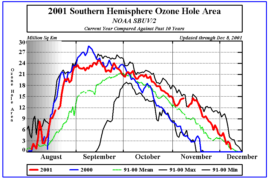
Again, if you check the facts you can see that this is easily disputed. Here [nasa.gov] is a graph showing the size of the ozone layer since 1980. The 2002 datapoint of about 15 million km^2 isn't even on there (a little more than 1/2 of the 2000 size). CFC aerosol cans were banned in 1976 and the Montreal Protocol was signed in 1989. Can you see any kind of link in the ozone size to this reduction on "greenhouse" gases? Are you honestly trying to convince me that these two are somehow related? Why would the hole in the ozone reach its peak a full 11 years after the Montreal Protocol was signed?
Interesting graph. However, your explaination which goes along beside it is badly flawed.
The Montreal Protocol was considerable modified over a ten year period. Each of these modifications had a significant effect on stratosphere Cl concentration. In 1998 the WMO predicted that the concentration of Cl and Br should peak at approx. the year 2000. (Source)
Unsurprisingly, the peak has occured, and now the ozone hole is starting to shrink.
I'm sorry, I let my subscriptions to all the 1970's scientific publications run out. I guess that means this is propoganda.
I guess your right. But don't take it too badly, as all of the conservative think tanks have also failed to find a peer reviewed scientific publication which supports this. That they still try and link the two together says more about them, than anything else.
Actually, Peter Singer (one of the more lefty whacko's out there) has written several books on a variety of subjects, including the "global freezing" scare of the 1970's.
I must be confused here, as the only Peter Singer that I've heard of isn't a scientist of any kind. Surely your not trying to suggest that because a non-scientist says something, scientists must agree with him. Perhaps you could supply links to Peter Singer the great climatical scientist?
Give me a list of scientists that support this theory, and I'll show you a list that don't.
Here is a list of contributed to a IPCC report on the Science basis for climate change. And here is a list of scientists who have reviewed their report.
I await your list with bated breath. And as a little hint, if you are planning on submitting a certain petition, then you might like to read Scientific American research into it first.
Its just plain bad science, and the only reason people think it is supported by a majority of scientists is because it isn't politically correct to argue it. For example, here [cnn.com] is the CNN writeup of the shrinking ozone hole this month. The size of the hole reaches a 12 year low, and the only scientific opinion expressed is: "Scientists caution that the data are insufficient to conclude that the fragile ozone layer is on the mend.
Perhaps you should read up on science as a whole, before slagging off the scientists cited by CNN. What they said was entirely correct. -
Re:The Club of Rome
Guess what...
The Sky is not some two deminsional curtian hanging above us.
The Earth is not flat.
The molucule is not the smallest particle of matter
And the world is not comming to an end.
I beleive it was Mark Twain who said, "There are three kinds of liars in this world; Liars, Damn Liars, and Statistics." The biggest problem here is people associating facts that are not intrensicly related.
Many people question the accuracy of actual global warming. "Official" temperature measurements are most commonly collected today at airports which have large tarmacs and big jet engines going all day. Maybe, just maybe, that's skewing the data more than my mom's can of AquaNet. Even one of your own sources admits that cannot rule out the effects of solar patterns.
As for finite resources, that's a problem of using a finite mind. I bet the folks at ADM would like to have a word or two with you on that one.
The bottom line is we mere mortals will never have any serious effect on the planet. History has shown that mother nature always wins. Dinosaurs come and go, but the planet moves on. Get over yourself. -
square cube lawThere is a practical limit to the size of animals. Their weight goes up as the cube of their dimensions. But the strength of their bones goes up only by the square of their dimensions. It puts a practical limit on the size of flying creatures.
Isaac Asimove wrote one of his science essays on this. I remember reading it as a kid. I remember he calculated that a winged horse, like Pegasus, would need a wingspan of 200 feet -- just like the Gossamer Condor.
One of the Alaskans compared the mystery bird to a Twin Otter .
"At first I thought it was one of those old-time Otter planes," Coupchiak said. "Instead of continuing toward me, it banked to the left, and that's when I noticed it wasn't a plane."
The Otter's wingspan is 65 feet for crying out loud.The bird was "something huge," he said. "The wing looks a little wider than the Otter's, maybe as long as the Otter plane."
-
Re:Sugar cane to make "biodiesel" instead?
Ahem, not only that, but the "smoke" resulting from such engines would smell like french fries! Hmm.
-
Should have known better...
The network engineers at Worldcom should have known better than to do an upgrade during a time of high solar activity.
What were they thinking? -
HERE I AM
-
Re:This is really cool and all but...Is dry ice possible at the extreme pressure of the deep sea floor? I know, sofar acknowledged he/she really meant Methane hyrdrate ice, not dry ice. Still, I was curious. I found this page, which has an account of experimenting with liquid CO2 at depth. At that pressure CO2 is liquid, and denser than water.
The clathrate the article mentions is a kind of slush of water ice with something else dissolved in it. So the methane hydrate we discussed is a clathrate too.
-
Re:You didn't...Yep, that's it. Two licenses required:
1) The remote-sensing permit from NOAA assures that we act in accordance with international treaties in regard to the imaging. NOAA also inspects for compliance with other things, like the Outer Space Treaty (especially with regards to space debris control).
see http://www.licensing.noaa.gov/2) The export permit lets us ship the spacecraft to Baikonur for launch. State does a rather meticulous inspection of the company's methods for handling technology security to avoid illegal technology transfer.
see http://www.pmdtc.org -
FALSE ALARM! No X class flares today! (yet)Nothing listed on www.spaceweather.com indicates an X class flare at 13:00 utc today nor do any of the other usual websites.
This is the information from SEC (NOAA): Only a few C class events are listed:
0221 UTC C2.8
0955 UTC C8.8
0930 UTC C6.7
You can easily see all the recent events from this plot of solar X-ray flux: (updated in real-time)
There was a minor X class flare last friday (as you can see from the plot!). This is what the poster may be refereing to:
8/30/02 1329 UTC X1.5 Sunspot 95
It was a limb event and isn't headed our way. The plot shows there were no X-ray flares today!
X class flares are fairly common (once every 2-3 weeks these days...) Usually they are near the limb or backside events and don't effect us other than a little radio interference. We might see an earth directed one from region 95 in the next few days. (But don't count on it!) If there is an X-ray event indicated by www.spaceweather.com, then check this alert page at Solar Terestrial Dispatch. These impact predictions are often very accurate! (Only updated if there is a strong earth directed event!) -
NASA contrail images
I can't seem to find it now, but I've seen a NASA picture (super high res color) of the Eastern Seaboard that was just COVERED with contrails.
Here's everything that I can find in 5 minutes, it comes close to showing what I saw once. (I swear it was from the Terra satelite, but I can't find it right now)
http://www.wrh.noaa.gov/Flagstaff/science/contrail
http://visibleearth.nasa.gov/cgi-bin/viewrecord?28 69
http://www.wrh.noaa.gov/Flagstaff/science/contrail s040595a.gif
http://visibleearth.nasa.gov/cgi-bin/viewrecord?53 46
http://visibleearth.nasa.gov/cgi-bin/viewrecord?47 43
Ships put out an amazing amount of water vapour, and photos of the Western Seaboard have shown huge numbers of ship generated cloud banks off of San Francisco. Here's one example:
http://visibleearth.nasa.gov/cgi-bin/viewrecord?11 335 -
Light Pollution in US
-
Re:NOAA
Speaking of meteorological programming, ALL the major atmospheric models are written in FORTRAN. The ETA, AVN, NGM, MM5, WRF, and scores of lesser-known models...all of them written in FORTRAN (most of them FORTRAN-90 now, but some of the older ones are FORTRAN-77). The MM5 & WRF may be found here and here. The source code to several others is readily available as well if you're so inclined, for instance the ETA and the ARPS. Anyone wanting to run them may do so fairly easily on a PC running Linux (any new PC will be able to run a fairly hi-res model real-time); I do so myself.
-
Re:Slightly offtopic
Yes, assuming you live in the USA (I don't know about resources in other countries).
There is good solar radiation data at:
http://sol.crest.org/solrad
This will give you a lot of good data on how much solar energy you get where you live. This info is web-based and free. As for wind power, I was able to get vast amounts of historical wind data from the National Climate Data Center. At the time, you had to buy the data (it was cheap) and ftp it. I think they offer quite a bit of it free via the web now. They are at http://www.ncdc.noaa.gov/
I hope this helps! -
pollution's effects on weatherNASA and NOAA do (or fund) quite a bit of research into the type of phenomena where aerosols (tiny particles) in pollution (think soot) cause rainfall or the lack of rainfall. Check out some of the research (and nifty images of Earth) regarding this topic:
- Changing Our Weather One Smokestack at a Time
- Thunderstorms are affected by Pollution (May 2002)
- Tiny Particles of Pollution May Carry Large Consequences for Earth's Water Supply (December 2001)
I realize these links have a bias for NASA but NOAA is also actively researching this area.
-
Sonar and whale strandings
Though this issue is a bit overhyped, once in a while, the Navy does kill a few whales. For instance, in March, 2000, 17 beaked whales died due to getting battered with sonar. (Link to NOAA press release here.)
-
Re:we all know what a disaster Freon was... try ag
Where in the hell do you think the chlorine from cfc's comes from? The earth, it all the same stuff, other than a hadfull of atoms made in cyclotrons and the few million obliterated in nuclear explosions we have not created/destroyed any elements.
No. Fucking. Duh. However, the vast majority of chlorine used in industry comes from a natural source that is (a) always found as a solid or in aqueous solution, and (b) very inert. This source is NaCl. The commercial process used to create nearly all industrial chlorine is to take NaCl(aq), a.k.a. brine, and electrolyse it into HCl and NaOH, thus releasing it from its inert state and allowing chlorine-containing compounds with higher enthalpy to be produced. Persistent gaseous suspensions of NaCl are unheard of outside the very bottom of the troposphere, since it gets rained out rapidly, and there isn't exactly an abundance of ocean water pouring directly into the stratosphere. Use some freakin' common sense, man.
As I said because of the semi-stable configuration of cfc's they have a larger effect than their numbers would otherwise suggest but they are still dwarfed by naturally occouring phenomena. Oh yes and since the spotlight has moved off the ozone whole over antarctica the whole has healed over 85%.
Your facts are 10 years out of date. You have been mislead. To quote Section 3 of the faqs.org link:
During the years 1978-1987 the hole grew, both in depth (total ozone loss in a column) and in area. This growth was not monotonic but seemed to oscillate with a two-year period (perhaps connected with the "quasibiennial oscillation" of the stratospheric winds.) The hole shrank dramatically in 1988 but in 1989-1991 was as large as in 1987, and in 1992-95 was larger still. In 1987 and 1989-95 it covered the entire Antarctic continent and part of the surrounding ocean.
-
FCC
If people are using different "bands" of electromagnetic radiation to communicate and/or conduct interstate commerce, does that then bring such communication within the purview of the US Government's regulatory ability?
I don't know (and don't have time to look it up right now) if the FCC's regulation applies to "radio transmissions" or "electromagnetic transmissions" and if it does, does one need a license to use this "new" medium?
What about NOAA? If people are hitting clouds, should the National Weather Service get involved?
*shrug* just a thought... -
Re:Well I hate to burst your balloon but...
I've launched a rawinsonde a few times for the NWS, and frankly I don't have a clue as to where they think that these things stay up in the air for more than MAYBE 6-7hrs, let alone 24.
BTW, balloons burst about 2-3 hours after release, then they fall back to the ground via parachute. Granted it's a slower trip back down, but still...
I'm thinking they've taken too many pulls off of the hydrogen tank.
Check out some upper air data...
Another link...
See how many flights make it up to 110kft?
Alot more make it to 90kft...
NWS Upper-air Observations Homepage
Too lazy to log in,
wxnerd -
Re:Hot Air?
Actually, they use Hydrogen too, as it is very much cheaper, and doesn't need to be carted around in tanks.
Hydrogen can be generated in large amounts using a chemical reaction.
(Calcuim Hydride + water-> Hydrogen Gas + Slaked Lime)
Slaked Lime is pretty environmentally safe to get rid of, and requires little special handling. -
One-Way Satellite
Internet in Africa is flaky at best. I work on a project called RANET . It is an effort of serveral partners (ACMAD , NOAA, and USAID to name a few) to make climate and weather related information more accessible to rural populations and communites.
We use the Worldspace Satellite system to send climate information in HTML format (it's a 1 way digital radio system, that when hooked up to your computer, acts as a modem). The villages get the information, then in turn translate it to the local language. We have set up low power FM radio stations and then they broadcast the updated data over the radio waves. Wind up radios made by Freeplay have been given to the villages, and they can tune in to the broadcast, and find out if some of the local watering holes have dried up for example.
I was over in Niamey, Niger a few months ago training users from Ghana, Niger, Chad, and other african countries how to code HTML so then those local countries can upload their climate information to us so we can send it over the satellite system.
We ran into some interesting problems concerning the interent. The local internet provider charges by time spent on the internet. Well, since they understand they can make some money by doing this, they actually slowed down everyones internet speed so they would be on the net longer, and be charged more. When a local person complained about this, not only did they turn off his phones and internet at his workplace...they turned off his phones and internet at HIS HOUSE. -
Re:Days of denial are over.For example, sea temperature data has been inferred from characteristics of coral growth
Sea temperature is measured by satellite, not by inferring from coral growth. A correllation may be seen between coral growth and sea surface temperature, but the temperature is not measured by looking at the growth. See this NOAA site
2) Which "theory" are you referring to when you talk about global warming? As far as I know, the only theories are:
1) CO2 increases cause warming (trivial physics, but not a real hypothesis to test man-made global warming in this complex system).
2) Computer simulations show warming, and with enough tuning can sort-of match the past since temperature records were kept.Number 2 (computer simulations) Isnt a hypothesis, or a theory, it is an attempt to verify the global warming hypothisis that you state in 1. A computer simulation is not a hypothesis in any case.
So really were only arguing about 1. Does an increase in Co2 decrease the rate of heat radiated by the planet. Thats the question. Does CO2 trap heat? Your alternative hypothesies, solar irradiation etc, may or may not be true. If solar variability is true, then that will contribute to an overall warming effect. Regardless we know one simple fact that cannot be disputed: CO2 traps heat. If it werent for some CO2 wed be living in an icebox. CO2 allows for liquid water, which then takes over as the dominant greenhouse gas. An increase in CO2 can therefore be assumed to increase the amount of heat trapped by the earths atmosphere, since CO2 has been doing that since the beginning of time. Regardless of any other causes to global warming, increasing CO2=Increasing trapped heat. So you may be right and solar variability may be a factor, granted, but this does not negate the effect of CO2 on the atmosphere. In fact it makes controlling CO2 even more vital, since we have to compensate for solar variations as well as human caused effects.
-
Re:Hear the Bloop
NOAA has a bunch of mysterious sounds, each scarier than the next. Try "Julia" or "Slowdown" on for size, but not if you're by yourself in the dark thinking about what lives on this planet that we don't know about.