 Slashdot Mirror
Domain: satobs.org
Stories and comments across the archive that link to satobs.org.
Comments · 39
-
NASA has confirmed that IMAGE is alive
http://www.satobs.org/seesat/J... Engineers at GSFC have acquired the suspect S-band source using the 4m CTA (Compatibility Test Antenna) here at GSFC (.jpg attached and no I’m not in the picture). They acquired the signal while the target was on ascent at about 2RE. Center frequency (CF) was between 2272.478 and 2273.418. The difference between IMAGE documented CF of 2272.5Mhz can be attributed to expected Doppler. Subcarriers are visible as well 1.7Mhz from CF as expected. The signal strength was oscillating. Plots will be forthcoming. The oscillation is not unexpected given IMAGE’s loss of spin balance. All indications so far suggest that this is, in fact, IMAGE. Richard J. Burley
-
Interesting find
This is a very interesting find.
Apparently NASA will try to contact the satellite using the Deep Space Network, and assess it's condition.
Right now JPL is in the process of digging up the 13-year old "owner's manual"
-
Re:Good.
If you want to paraphrase something then cite it. At night, in clear skies, you might be able to spot a proportion of satellites with the naked eye, but not necessarily to focus on them as they're so far away. In daytime under any conditions, which is what the FAA regulation is about, not even this applies.
-
Re:Good.
1. Actually, it's often pretty easy to spot satellites. Visibly. There's 100-ish that are brighter than mag 4 (the limit for unaided vision in perfectly dark skies is 6, about 100-fold dimmer). If the position and angle are right the ISS can be mag -5.9 - an order of magnitude higher than the peak brightness of Venus, and readily visible during the day if you know where to look. Most commonly it's -2 to -4, so roughly between the average brightness of Jupiter and the average brightness of Venus. Iridium flares can get on rare occasions up to a staggering -9.5, though they usually max out at around -8.
2.Whether you're talking about radio or visible is irrelevant. What's relevant is that you're changing the angle of the "sight", from the horizontal to the vertical.
-
You can see one yourself
The following is from Ted Molczan, an expert on satellites and launches and a major contributor to the seesat-l list. There's a good change of seeing a fuel dump from a Delta 4 medium if you're in the right place at the right time.
WGS 5 is scheduled for launch from Cape Canaveral on a Delta 4 Medium+(5,4) in about 11 hours, on 2013 May 24, between 00:27 and 00:57 UTC.
http://www.spaceflightnow.com/delta/d362/status.html
I offer the following rough TLE of the orbit after the final burn of the 2nd stage, assuming launch at window-open:
SECO-2 440 X 66991 km
1 78901U 13144.04069444
2 78901 24.0048 67.6288 8299446 177.8402 1.4113 1.08160032 04
Following spacecraft separation, observers within range should look for the following 2nd stage events (times
approximate):
T+ UTC
00:45:00 01:12:00 CCAM Start (Collision and Contamination Avoidance Manoeuvre)
00:47:20 01:14:20 CCAM End
00:54:41 01:21:41 H2 Depletion End
00:56:40 01:23:40 O2 Depletion End
01:18:33 01:45:33 N2H4 depletion EndThe fuel dump could produce a spectacular comet-like phenomenon, similar to that of WGS 4, imaged last year despite
challenging conditions by Willie Koorts: http://satobs.org/seesat/Jan-2012/0270.html -
Re:Missle fuel dumps or staging, common phenom
The following is from Ted Molczan, an expert on satellites and launches and a major contributor to the seesat-l list. There's a good change of seeing a fuel dump from a Delta 4 medium if you're in the right place at the right time.
WGS 5 is scheduled for launch from Cape Canaveral on a Delta 4 Medium+(5,4) in about 11 hours, on 2013 May 24, between 00:27 and 00:57 UTC.
http://www.spaceflightnow.com/delta/d362/status.html
I offer the following rough TLE of the orbit after the final burn of the 2nd stage, assuming launch at window-open:
SECO-2 440 X 66991 km
1 78901U 13144.04069444
2 78901 24.0048 67.6288 8299446 177.8402 1.4113 1.08160032 04
Following spacecraft separation, observers within range should look for the following 2nd stage events (times
approximate):
T+ UTC
00:45:00 01:12:00 CCAM Start (Collision and Contamination Avoidance Manoeuvre)
00:47:20 01:14:20 CCAM End
00:54:41 01:21:41 H2 Depletion End
00:56:40 01:23:40 O2 Depletion End
01:18:33 01:45:33 N2H4 depletion EndThe fuel dump could produce a spectacular comet-like phenomenon, similar to that of WGS 4, imaged last year despite
challenging conditions by Willie Koorts: http://satobs.org/seesat/Jan-2012/0270.html -
Re:"Wantonly violated?"
What makes you so sure that we didn't shoot it down?
Because these guys have observed and photographed it.
-
Re:"Wantonly violated?"
What makes you so sure that we didn't shoot it down?
Because these guys have observed and photographed it.
-
Re:That's interesting
I still do satellite observation, as do many others. I remember talking to a cosmonaut of MIR while watching him go overhead. I asked him how the sunset just was, and he wondered how I knew they'd just seen a sunset. I told him I just watched him pass into the terminator. Kinda blew his mind.
-
Re:Weight and telemetry
Those things are a necessity when the camera is a mission-critical piece of kit
Not really true - it only takes one piece of non launch-rated equipment to mess up the whole works. Imagine it shorting out or breaking into a zillion pieces on launch and getting into the science instruments.
Your idea would work if it were physically and electrically separated from the main payload, but that would entail a lot of extra weight.
The microswitch probably did its job - the sat probably moved enough to trigger that. The fact that no amateur satellite watchers have seen it and the Air Force hasn't found it with radar are good indications that it hung up on deploy.
-
Re:Will it..
Actually it might. This is a sigint/comint bird.
You can keep tabs what orbital slot it ends up in by watching the seesat-l mailing list that Ted Molczan contributes to.
-
Re:It's just a jet contrail
An expert named Brian on the seesat-l list says:
This pops up every once in a while. Seen it myself.
It's an airliner leaving a contrail that's being lit by the setting sun.
Yeah, I've seen that myself, one time when driving... I could see a 'smoke trail' rising from the horizon, but after traveling a few more miles it was clearly just an aircraft contrail creating an optical illusion.
-
It's just a jet contrail
An expert named Brian on the seesat-l list says:
This pops up every once in a while. Seen it myself.
It's an airliner leaving a contrail that's being lit by the setting sun.
It appears to be going straight up because it's coming straight towards
the observer from over the horizon.If we had a time, direction, and location of the viewpoint it would
not be difficult to determine which flight it was.The contrail more than likely also shows on satellite weather imagery.
As many of us here know who have observed known missile launches, this
thing is moving WAAAAAAAAY too slow. -
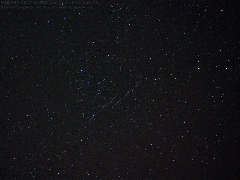
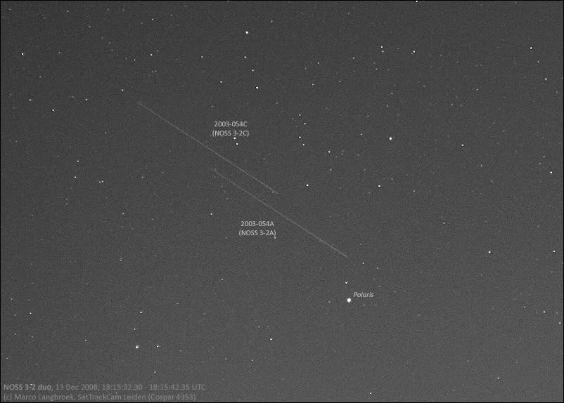
Something like the classified NOSS???
The US Navy has quite some experience (decades, actually) with formation flying with their NOSS (Naval Ocean Surveillance System) SIGINT satellites (http://www.satobs.org/noss.html). The old one flew in tight triangular formations of three (quite a sight to see), the newer ones do it with two. They serve to pinpoint ships based on their radio communications.
Also, the Chinese appear to be experimenting with a similar concept (http://www.nasaspaceflight.com/2010/08/china-launches-military-satellite-yaogan-weixing-10/).
Here are two pictures I shot of two of the newer NOSS formations, NOSS 3-4 launched in 2007 and NOSS 3-2 launched in 2003:
http://i19.photobucket.com/albums/b176/marcoaliaslama/satellites/170109NOSS3_4.jpg
http://i19.photobucket.com/albums/b176/marcoaliaslama/satellites/131208NOSS3_2.jpg -
Re:Collision course
There are plenty of sats tracked by the seesat group that change orbit. The Lacrosse and USA birds come to mind. Buried in the archive are messages about sats being early/late/missing with regard to very recent orbital elements; that usually indicates a burn.
The NOSS formations have been seen to reboost, as has VORTEX 6.
-
Re:Doctor, Doctor, it hurts when I do *this*
How about the other type of tether - the long one. (gravity-gradient) There were supposed to be 3 shuttle experiments with tethers, and at last report I think they'd done the first and smallest, and had trouble with the second. (snarling/breakage?)
http://adsabs.harvard.edu/abs/1989fmet.symp..149L
http://www.satobs.org/tss.html
http://code8100.nrl.navy.mil/programs/tips.htmThe actual shuttle experiments seem to be concerned with "dropping" a probe into the very upper atmosphere for measurments and observation. The third reference, non-shuttle deployed, seems to be materials/duration research.
None seem interested in generating effective gravity or skyhooks/pinwheels.
-
Re:NORAD data is public
This is a kind of "negative proof" that's very difficult to disprove. How can one prove that a secret document does not exist somewhere? But there is a logical reason why it isn't in anyone's interest to keep some orbital debris secret.
No, you're totally wrong. This is nothing like "negative proof". There is a thriving community of people who visually track satellites whose elsets do not appear in spacetrack's database. Spacetrack's data is not public, you have to register and be approved to redistribute it, and even so, it is the "civilian" database and only contains unclassified data.
I agree, it would be very logical for DoD's data to be public. But it isn't and they aren't.
-
Re:Confused
This reminded me of a previous slashdot article, which talked about spy satellites with undisclosed orbits. There is an amateur astronomer group that tracks them (and others).
-
Note
John added the solar panels in the first image.
see the following note from him:
http://www.satobs.org/seesat/Jan-2008/0204.html -
Remember ICESAT?
http://icesat.gsfc.nasa.gov/
http://science.slashdot.org/article.pl?sid=07/02/19/1319228
observing:
http://www.satobs.org/seesat/Oct-2003/0064.html
Icesat is looking at this ice. This UAV is looking under the ice. I wonder if these folks should be working together? -
Re:let 'emThese guys do it all the time. http://www.satobs.org/ It requires a telescope... a knowledge of mathematics and orbital mechanics or a computer built after 1992 or so and an open source sat tracking package, and of course copious free time and lots of coffee. Yeah, finding sats when you know where to find them is easy, but finding them where the US says there aren't any is a bit harder.
-
Re:let 'em
These guys do it all the time. http://www.satobs.org/ It requires a telescope... a knowledge of mathematics and orbital mechanics or a computer built after 1992 or so and an open source sat tracking package, and of course copious free time and lots of coffee.
-
Re:Transparency
Invisible, my ass. http://www.satobs.org/
-
ICESAT is Cool
Here is everything you want to know about this interesting satellite:
http://icesat.gsfc.nasa.gov/
There have been reports of people actually 'seeing' the laser as the satellite goes over:
http://www.satobs.org/seesat/Oct-2003/0064.html
New water holes way under the ice. Fun. I wonder if we will find even more 'new species' as was reported here:
http://science.slashdot.org/article.pl?sid=06/12/1 1/2336230 -
Looks like an Iridium Flare
Check out this guy who can summon UFOs on demand. Has a link to a news broadcast where they filmed him doing it. Shocked the hell out of the camera crew
Looks a whole lot like an iridium flare to me. Iridium flares are reflections of the sun off of satellites. Some flares can reach magnitude -8 or so, which is actually bright enough to be visible during the daytime.
It would be nice if the news crew had reported the date and time of the "sighting" so it could be cross-referenced with the predicted flares at heavens-above.com. Check out the site to catch a glimpse of flares visible in your area. -
More info here...
http://satobs.org/p_chien.html
But it states "lacrosse" is no longer the codename used for the project. -
Means no more satellite forecast
No orbital information means that you can't make and especially share satellite observation forecasts with your friends
Site like Heavens Above will need alternate source to make their forecast. This is a shame, accurate forecasts were a bonus to amateur observers and essential to observe some satellites.
Those who haven't observed a -8 Iridium are missing something. They are spectacular -
U.S. Withholding Satellite Data -- copyedited
plover writes "Due to Congressional legislation passed quietly in 2003, the Air Force Space Command will no longer distribute space surveillance data via NASA. There was supposedly a three year transitional period when the data was to be made available via a NASA web site, but earlier this month their transitional server went down hard. NASA has decided not to rebuild it. (It was scheduled to be shut down on 31 March 2005 anyway.) The only way to obtain satellite data now is by signing up with the official Space-Track website. Part of the agreement to necessary to obtain data from their site is not to redistribute it. Of course, amateurs are still free to redistribute their observations, including those of classified satellites."
-
Re:Well then.
Just try to imagine a Soyuz-based mission to fix the Hubble.
I don't see any problems here at all. What specifically makes you say it can't be done? The Soyuz can be brought to the same orbital plane as Hubble. The Soyuz can maneuver in space - and if you think it doesn't have enough fuel, just send a Progress ship to dock with Soyuz. The Soyuz has airlock. The Soyuz can fly with two people onboard, and extra cargo, needed for repairs, can be taken along.
Best of all, all of that was already successfully tried. Soyuz-4 and Soyuz-5 have docked in space in 1969. Progress was used to boost the orbit of another ship, ISS in this case. The Soyuz' airlock is the orbital module. Soyuz have flown with two people on board. Soyuz was actually used to repair a station in space, when all the control was lost. -
Re:Teach Critical Thinking...For argument's sake... tell me again why we can read license tags from space but cannot get some decent pictures of the Mars surface?
For the sake of argument, let's assume that it is possible to read license plates from space. The angular size of the numbers on a license plate (~1 inch) as viewed from low Earth orbit (~200 mi) is on the order of about 1e-7 radians.
The closest approch of Mars to Earth in the last fifty thousand years was about thirty-five million miles. Assuming the same angular resolution, that same telescope pointed at Mars should be able to resolve details about five miles across under absolutely ideal conditions.
In practice, the idea that satellites can read license plates is a myth. See here.
Can spy satellites actually read automobile license plates?
To actually read license plates, you'd need to put something like the Keck telescope in orbit--and ten-meter scopes don't generally fly well. Even then, you can't get great pictures of Mars. The only way to get high-resolution photographs of Mars is to send a probe there and take pictures from Mars orbit--which is exactly what NASA has been doing. So far, there hasn't been anything which suggests more than microbial life on Mars, and even that's still very much an open question. We do know there aren't obvious large-scale features of civilization--dams, highways, walls, skyscrapers.Probably not. They most certainly can tell how many people are standing around a car, and perhaps what type of car it is, but actually reading the license plate is not an easy task. Look at the physics: Say the telescope has a 1 m (39 inch) primary and is orbiting 322 km (200 miles) altitude. The theoretical resolution of the telescope (i.e. the best possible) is 0.114 arcseconds (at visible wavelengths). At 322 km, the 7.6 cm (3 inch) tall license plate characters subtend an angle of about 0.048 arcseconds - less than half the size needed to be resolved. A spy satellite, under the *best* of conditions could tell the car *has* a license plate, but given the license plate is most likely being viewed obliquely, and probably at a range *greater* than the satellite's altitude and looking though the atmosphere, one quickly determines spy satellites cannot resolve a license plate.
-
Semi-related - other stuff in the skyI realize not related to the space station, but still looking up in the sky at night, the most obvious thing is the moon
Another cool thing is Iridium Flares which are bright flashes of reflected sunlight from the Iridium satellite solar panels for 5-20 seconds - here is an excellent writeup about those including how to predict 'em!
-
Iridium flare.
When I saw the picture I thought it looked a lot like an Iridium flare- a glint from the solar panels from the Iriduim communications satellites.
-
For those with only a passing interest
For all of the armature astronomers out there with a passing interest in this stuff, here are some helpful links for this years storm:
Where to find a dark place to view from: DarkSky.org
The storm forecast by city (US/World) from NASA: NASA
Astronomy Links In General:
NASA's J-Pass Satellite Passes: Near earth objects(Java,Email)
NASA's SkyWatch 1.4: Excellent for finding events (Java)
Satellite Related Software: For UNIX, Mac, Windows, Palm & more
SpaceWeather.com: Plan to see the auroras
SlashDot.org: Leonid's Last Year
Weather.com: Don't forget to check before you leave
By MichaelCrawford: This
Tips: viewing and what I bring with me.
-
Resolving power?
Sure, I'm all about tracking stuff visually, so you can actually *see* what it is you're tracking, but what's the resolving power of the facility? If I recall correctly, the US already tracks thousands (if not hundreds of thousands or millions) bits of space junk, down to the size of small bolts. If the Russians have an optical facility that can resolve those, then I'll be truly impressed.
The best optical imaging of orbiting objects I've ever seen came from a Boston museum (I think), which managed to use the GOTO[1] functionality on a 12-inch telescope to track the Shuttle while docked with ISS. If you squinted, you could just recognize it. And they fly in a (relatively) low orbit. [here's a site with some nice shots]
So, again, if they can manage to optically track very small objet d'junk, I'll be very impressed. If they're only visually tracking larger objects (like, say, US spy satellites), then I'd say they've probably got a different purpose in mind.
[1] See? Not all GOTO's are bad! -
Iridium FlaresOne of the very cool things about the Sattelites is the Iridium Flares. Basically, they look like a slow moving, super bright shooting star.
I have had the opportunity to see these first hand a couple of times, and I can say they are super neat. If you are ever out camping, look it up and see if one is gonna pass over head. The above mentioned site has lots of resources on where they can be found.
pk
-
infoEUVE Archive
EUVE Home (UCal. Berkeley)Info on satellite tracking here. Track the orbit, and place bets on where it will land. (note, the farthest north is someplace in florida.)