 Slashdot Mirror
Domain: msss.com
Stories and comments across the archive that link to msss.com.
Comments · 139
-
Re:Provocative Pictures from MOC
Okay, first recognize that I'm not an expert at interpreting these images. Like most folks on
First, here's the main page for this image. The picture was taken mid-spring. Solar Longitude, or Ls tells us this. 0 degrees corresponds with vernal equinox (spring) in the northen hemisphere, and then each season is 90 degrees in length. This image is from the southern hemisphere (82 degrees south). It's also not terrbly well lit, as the incidence angle is 79 degrees. My semi-educated guess is we're looking at years of CO2 deposits trapping dust, sublimating, and then releasing dust in layers. In the north, dust has been blown across exposed rock to the north as the CO2 turns to gas and pushes north.
The Martian polar regions behave very differently than do the polar regions of Earth, since much of the polar caps are CO2. It goes right from solid to gas, so there is no flow, and impurities drop right where they were trapped, and don't move except for aeolian processes. We continue to study these polar processes in-depth as we have targetting campaigns to image the entire polar region during the spring and summer to observe these phenomena. The amount of change the poles go through every year is nothing short of amazing.
Also, do yourself a favor and always look at lossless images. JPEGs are really only useful for gross classification or mnemonics to find what you're looking for. Especially if you zoom in, the artifacting process in JPEG compression makes things appear that aren't there.
And yes, I do agree that the whole planet needs further exploration. Mars is an amazing place, and even if there is no biological life on it, it's still a living planet that is so amazingly similar to the Earth, and yet so alien, we will learn much about the universe and ourselves with continued study.
-
Re:Provocative Pictures from MOC
Thanks for the explanation. They are certainly very curious photos though. Too bad the site is already slashdotted. You do agree that they need further exploration I hope. Do you know what the image I linked from MSSS shows?
-
Provocative Pictures from MOC
There are some rather strange images from the Mars Orbiter Camera that don't appear to show geologic activity at first glance and do resemble bacteria beds or something organic. We need to go investigate!
-
Provocative Pictures from MOC
There are some rather strange images from the Mars Orbiter Camera that don't appear to show geologic activity at first glance and do resemble bacteria beds or something organic. We need to go investigate!
-
Re:When NASA gets it right,
"These things have dramaticly outlived their projected lifetimes, while their british counterpart didn't even survive to the first day."
Don't be so hard on Beagle; space travel is hard. Or have you forgotten the spectacular failures of NASA's own Mars Observer and Mars Polar Lander? -
Re:You dork
However, it no longer carries the working spectroscopic instrument and hence the HST is no longer a viable asset for my need.
FYI, there are 4 other working instruments on board (WFPC2, ACS, NICMOS, FGS). So, just because the STIS, the one you are interested in, is dead, you are willing to throw the others away? To hell, with the rest of us and our science, right? I routinely use Hubble data from STScI, but you don't care, huh?
What about the new instruments that would be installed? Including the COS (Cosmic Origins Spectrograph)? Your selfishness ought to support us at least for that.
Today, it is probably more cost-effective to go back to expendable space missions.
So instead of supporting STScI (an institution which attempts to support the astronomical community by promoting itself as an educational institution & releasing all data returned & software developed to the general public) you prefer to support Malin Space Science Systems. The for-profit company which has monopolized the majority of the imaging on the disposable, robotic missions over the past 15 years? The company which attempts to copyright & commercialize the data it returns?This is the institution that produces very crappy software to handle the HST data (I've written my own code to process and done my own calibration to improve its science return...why was the STScI not doing that?).
You mean the institution which created & released such software as STSDAS, TABLES, MultiDrizzle, PyRAF and other standards of the astronomical community?
Where is the software have you created & released for public use?
I am an amateur astronomer. Have been for over 20 years now. The last 5-10 years have seen a revolution in astronomy. Organizations like NOAO (who released IRAF), and STScI (who released STSDAS, et al + HST data) are pushing this revolution. Astronomers all over the world now have access to data from HST, IUE, EUVE, Gemini, Chandra, DSS, GSC2, 2MASS, etc.
The popularity and support which astronomy currently enjoys is due primarily to the way the STScI has handled the HST and its' discoveries. Otherwise, you might not have funding for your research (assuming you are a researcher.)
rho -
Re:Just a guess.
That crater isn't believed to have been caused by Beagle 2. It's to large.
Here is the official site for details about that image: http://www.msss.com/mars_images/moc/2004/08/31/ -
Space tourist souvenir
No, it's actually an inexpensive replica of the Face on Mars that some alien space tourist dropped. It looks just like a meteorite because the photos were taken with wrong illumination and at wrong inclination, just like the images of the Mars Global Surveyor released by NASA supposedly to debunk the existence of the extraterrestrial artifact.
-
Re:how far away is Beagle 2?
Beagle 2 was supposed to land on Isidis Planitia (10.6N, 270W). Opportunity landed on Meridiani Planum (354.4742E 1.9483S). Spirit landed in Gusev Crater (175.4785 E 14.5718 S). Neither are nowhere near Beagle 2. I couldn't find a high resolution map of MARS with the landing sights, but this should give you an idea.
-
Re:Question
You said: "So what happens when the temperature (down to -90C) goes below the sublimation temperature of CO2 (-76C, if I recall correctly)? Does it just freeze out of the air?"
Most likely. The phase diagram for CO2 shows that for our standard atmospheric pressure, CO2 freezes at -78.5 C. If the temperature is only slightly lower than -78.5 C it may take some time for a significant amount of CO2 to precipitate due to the latent heat of solidification for CO2 of -43 cal/g (smaller than the absolute value of water which is about -80 cal/g) . Additionally some CO2 may remain in the air which varies by temperature (which would be relative humidity for water). As the temperature drops the amount of CO2 that can be dissolved in air decreases. Unfortunately I couldn't find a reference for CO2 saturation vs temperature. If it is reasonably low (which it should be) at -90 C, CO2 frost will develop.
On Mars with an atmospheric pressure that varies from about 5 - 10 mbar (1 atm = 1013.25 millibars), CO2 frost can develop as seen by Viking 2 and by satellite pictures of the poles. Snowflakes won't form, since the shape of a snowflake is determined by van der Waals forces (don't occur in CO2). CO2 frost should look similar to this. -
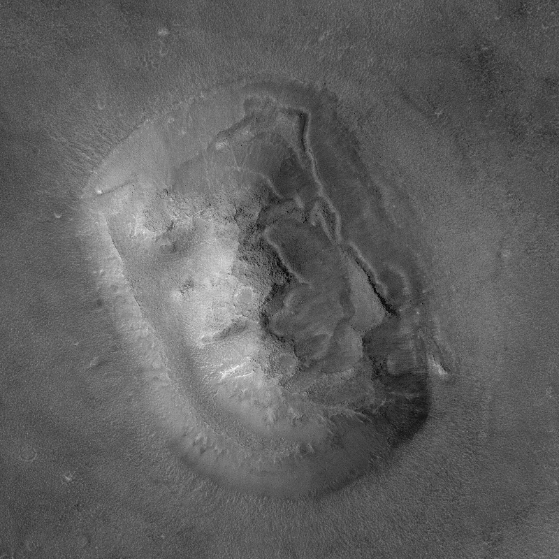
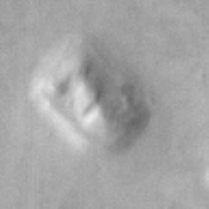
Re:Giant Faces
It was a reference to the face on mars which, not surprisingly turned out to not look like a face at all.
Of course, I originally read the comment as "...giant feces flowing across..." which kinda ruined my lunch. -
Re:more evidence...
I'm inclined to agree. Still, this really does look like the top view of some sort of growing structure. We have to assume it's abiological, of course; unless there's nothing that can create these without invoking life, it's probably something like you suggested.
It's funny how on Earth, of course, one would see those pictures and say, "Oh, hey, it's a forest" before invoking a gelological explanation. But here, life is the rule, of course.
-
Re:Winter on Mars?Sorry , but you can't have the whole planet in winter.
You could if there was no tilt to its axis of rotation relative to its orbital plane.
Mars, though, tilts about the same as Earth - 25 degrees or so. But its orbital eccentricity has a 19% variance, versus Earth's 2%. The 'Southern Winter' is much longer and colder than the 'Northern Winter,' and the whole planet is colder. The Martian Southern hemisphere experiences much greater temperature variance than any point on Earth.
-
Re:Oh no, not more features that look like faces!
Some faces they never talk about. Like the other face on Mars. (It did have a guest spot in the Watchmen graphic novel.)
-
The Face on Mars
Melted Penny
Face on Mars
Now we know how it must be a hoax, or a really big Martian penny. -
Re:Spirit and the Columbia Hills
I am really looking forward to when Spirit reaches the Columbia Hills. If Spirit successfully reaches the top of the hill the view will be breathtaking. Not only could we see the landing site but also see the actual rim of Gusev Crater more clearly. It will be an amazing sight!
I'd like to see that, too. But unfortunately, the current thinking is that we won't be climbing the hills when we get there.
In fact, I just had that conversation with Larry Soderbloom, one of the top scientists on the mission. My side was, basically: "But, Larry, the view would be so cool."
However, MOC images (MOC is the camera system on the MGS spacecraft) show that there's a lot of cool stuff in the hills' vicinity, making them a worthwhile destination anyway. There are rock outcroppings on the hills themselves, which we'll be able to see fairly well even without climbing to them, and several geological features of great interest in the 500m or so around the hills. (Now that we've upgraded the rovers' flight software, we're regularly covering 70m+ per sol -- indeed, we just set a new Spirit single-sol record of 92m -- so 500m is roughly a week of driving.) As a result, that area is likely to give us our best chance of telling the "water story" we came to Gusev to find.
Incidentally, we're shooting for reaching the hills in about 40 more days (we're targeting sol 160; we just planned sol 119). Stay tuned.
FWIW, as spectacular as the view would be in other respects, I don't think the Gusev Crater rim would look any better from the top of the hills. It's faint because of the high tau (atmospheric opacity) caused by the global dust storm that preceded our landing, and which is still settling. Maybe the view would be better from a little higher, but I doubt it. The good news is that the rim is showing up better and better as the atmosphere clears, so we'll get better views of it over time even without climbing the hills. (If you've never noticed the rim in the images, you can see it in this image if you look carefully -- look to the right of the hills, at the right-hand edge of the image. It's faint, but that's the rim of Gusev Crater.)
-
Re:Don't you just love it!
Actually, the current record for "most powerful camera" around mars goes to Mars Global Surveyor's Mars Orbital Camera, launched in 1996, which itself was a duplicate of an instrument on the failed Mars Observer (1993).
-
meant 1998, heres links to pictures
-
what i find unrealistic
=is that no one has really posted any links to the images inquestion in order to provide any sort of balance to this argument. There are more images available of a "city"-like formation a few miles from the city. There's been math done to calculate orientation of the objects in question in relation to each other. Investigate this. don't write it off. Those in control of the flow of information are just afraid of letting every one else know what they may not be ready to know.
-
Re:Shiny!
Shamelessy reposted with some edits from Metafilter...
I thought at first it was just a digital photo artifact, but seeing as how the flash of white appears in several photos from Spirit's navcam on Sol66, my next thought was ALIEN BUILDINGS!!!
Okay, not really. My next thought was that it might be the lander's backshell or heatshield. So I looked up a map of the rover's intended route, and orbital images of the landing site with labels. Take a look at the photos, the maps, and the scales. Apparently the lander's heatshield had impacted a nearby crater; that's Bonneville. -
Re:Tell news
The ESA "discovery" announcement last month was accompanied by a cartoonish image of the Valles Marineris area. I have yet the see the source data for this grandiose conclusion. Visual evidence for an abundance of water on Mars dates from the Mariner 9 mission in the early seventies. No one has yet trumped the awesome observations of recently active gullies in Mars southern hemisphere.
-
Re:How'd they do it?Actually, a friend of mine is a system admin with JPL and he had to drive out to the San Bernadino soundstage where the rovers are being filmed and reboot the computer a 4AM. The funny thing is he left a tool chest and sleeping bag (he was using it to minimize footprints and body impression, not sleep on the job!) where the Opportunity rover was scheduled to peek over the horizon and the ensuing photo of the tool chest / sleeping bag on the horizon had to be quickly -- and deftly, I must say -- explained away as being Opportunity's back shell and parachuete.
Just another day in the life of a sys admin!
-
Re:Better way to dig
... or we could just drive the current rovers to where their backshells impacted. They're close by (440m for Opportunity) and have been imaged by Mars Global Surveyor. I also believe that Opportunity imaged some of its own jetissoned landing equipment as well.
See MGS Images of Parachute and Backshell and Opportunity's image of its own parachutes and backshell.
While this surely isn't a 500-pound high-speed impact, it certainly did kick up some dirt and has the HUGE advantage of already having been launched. -
Re:ReasoningYea, but clouds? I know it not hot and gassy enough to have gas clouds. And if it had water clouds that would have made the news a long time ago.
Mars has some temporary cloud cover around mountains where air is forced up into cooler regions of the atmosphere. There are also some fogs and clouds around the polar caps where water vapour and carbon dioxide condense out of the atmosphere, but that's about it.
There are some beautiful images here.
Best wishes,
Mike. -
Re:I'm curious...
I could be wrong, but I think you're probably in for a long wait - I've tried snapping the sky from here with a 3 megapixel camera and it's a waste of time, even with very long exposures, the resolution of the cameras they've got up there sucks even more so if you want to see the sky as spirit sees it just open paint, and do a pure black flood-fill
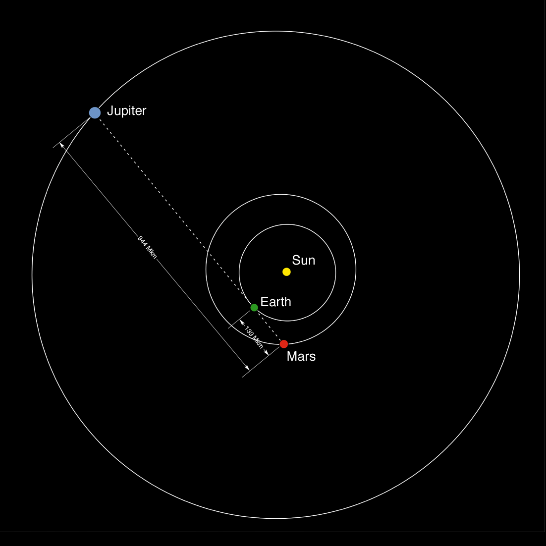
If you haven't seen it already, here's a picture of the Earth and Jupiter taken by the MOC, it's a *bit* of a cheat, but still a beautiful picture, and probably the closest thing humanity has to your dream of a alien starscape (which I agree would be a fantastic, but slightly bland picture -
Nice news...
Great! So we found water on mars. Now that this mystery is over, I think it's time for some real scientific work.
Send the rover to the 'mars face'. -
Re:Interesting polar ice cap picture
Look at that picture more closely, in the upper left corner. There's a lake! It must be - it even has surf.
Hot damn! I knew all this persistence would pay off. Water on Mars. And you "scientists" thought you were so smart. -
Re:Interesting polar ice cap picture
I dunnot about that, but this one looks like the lander caught fire. =P
Wait, maybe that's why the probe is "silent"...
They found oil! -
Re:Interesting polar ice cap pictureThe "interesting image" on the conspiracy theory website at least has the decency to link to the original source at NASA. If you follow the NASA link you too can discover a little piece of info that the conspiracists can't be bothered to tell you: in the narrow direction, the image of "plant life" is 2.83 kilometers across! This means each of those big bundles in the image is about 1000 meters/yards.... which is the same as ten American football fields put end-to-end.
That'd be a really big freaking tree. Or you might consider that it's a reasonable size for a geological feature.
Moral of the story: unless you have experience in interpreting geology from biology when looking at Earth images, you probably shouldn't bother trying to use Mars as your first experience in interpreting aerial imagery.
I know nothing about interpreting these images. Me, all I see is two different surface types. One of which sometimes is round with radial patterns in it. It means nothing to me.
-
Re:NASA's Record
one of which I have code helping to control the cams
I assume you work for Malin Space Science Systems? Which orbiter did you work on...tell us more -
That looks familiar
-
Re:The Face
How many photographs will be enough?
http://www.msss.com/education/edprog.html -
Look carefully..
If your eyesight is good you can see this..
-
Help Nasa hunt for the Polar Explorer
-
Re:Focus on impact craters
Definitely. Impact craters give clues about:
How recently were different parts of Mars resurfaced by flooding, weather, etc.
How long has the Martian surface remained unchanged, compared to Earth and other planets and moons
The distribution and characteristics of different ejecta morphologies (the shape of the blanket of material thrown around the crater by the impact) across the planet has been used to chart the depth and location of subsurface water and ice.
Craters which appear to contain sediments from ancient lakes have been studied as potential landing sites for future sample return missions.
A good site to read about crater classification
I would particularly suggest the south part of the planet, which is heavily cratered. The Noachis area makes a particularly interesting site.
I also run accross this good website with some basics in computer vision to automate the crater classification task! -
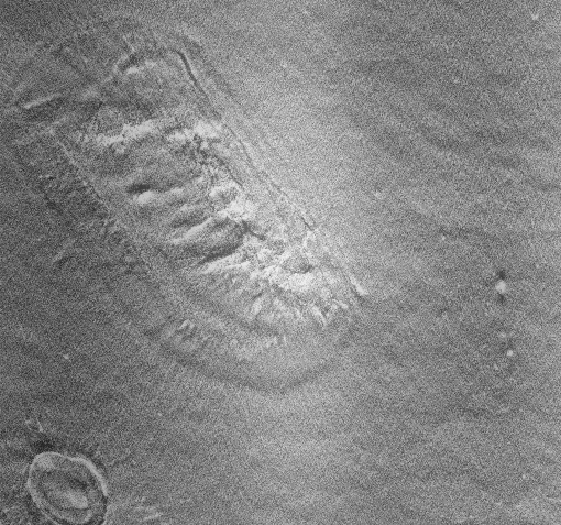
Footprint on mars..
Or they could check out this footprint - about half way down, slightly to the right.. If fact it reminds me of a day at the seaside, now wheres my suncream..
-
The Face and Pathfinder sites re-photographed
I'd like to see a report of the number of times each feature was asked for after they're done. I'm guessing 95% "monkey face", unless a large number of people vote "Pathfinder/Sojourner site".
Been there, done that.
Here's some shots of the Viking Lander site as well. -
Re:earth?
They did it already. Here you can see Earth, the Moon, and Jupiter, as seen from Mars orbit.
-
Re:What are your favorite flight sim games?
Ok, now I understand that all it's really changing the is scenery, but "fly a plane on Mars"? The atmosphere is WAY too thin for that, most planes would never get off the ground!
You can fly a plane on mars. See here.
There are quite a few things to worry about while flying on Mars, the most notable is the speed of sound differences. You have to have a plane that can fly supersonic while travelling at ~180 knotts. That's fairly difficult to manage, but it is very possible. -
That's Michael Malin
The president and chief scientist of Malin Space Science Systems.
FYI.
-
Re:Question.
Oh, thats too bad.. I wanted to submit an suggestion for 'Mons Cowboyneal'
-
Re:Does it constitute life? Tough call
Successful life tends to leave behind rather noticable evidence, evidence that we would probably have detected by now.
What, a giant face isn't enough evidence for you?! -
There is life on mars...
...who else would have made that smiley to welcome us?
happy face -
Of Course There's Life!
Someone had to carve that giant face !
Seriously, though... no, I got nothing. I'm a hack. -
Full resolution pics
Are available from here.
-
Re:Nice pics of home
Staggering that they could even get that pic.
They didn't, technically. The camera on the MGS is grayscale. They used stock photos to apply color to the images. They're totally forthcoming about this and the technique if you go straight to the source. -
Re:Images look funny
Or am I missing something?
Yes, quite a bit. First, the orbit of Mars is between those of Jupiter and Earth. But, that's not to say that we aren't closer to Jupiter, because right now, we are. So you're basically right on that. For now.
But the main thing is... don't you think those pictures were taken with quite a lot of magnification? With a large enough telescope, Jupiter does appear that large in our sky. Do you ever wonder why we can't see nebulae and all those other cool things out in space with the naked eye? If they appear so huge in photographs taken from the earth (or in orbit around the earth) why don't they appear that big to us? Why, it's the miracle of telescopes and magnification!
Seriously, you either had a brainfart (happens to all of us) or you don't belong here. -
Re:Larger image anyone?
Here is the largest one I could Google. Somewhat flawed, unfortunately.