 Slashdot Mirror
Domain: uscg.gov
Stories and comments across the archive that link to uscg.gov.
Comments · 43
-
Re:Trabant
Not as fundamentally daft as it sounds. Icebergs are pretty bomb resistant - hard enough to hold together, soft enough to not shatter, and enough thermal mass & latent heat to resist incendiaries.
-
Re:Why
The Law of Differential Masses says the larger ship gets right-of-way. The Law of the Sea, or more correctly the United Nations Convention on the Law of the Sea as well as the International Regulations for Preventing Collisions at Sea, says the more maneuverable vessel is the give-way vessel, but only when higher levels of responsibility aren't present.
An example of a higher level of responsibility? How about International Rule 8.f(iii), as defined by the US Coast Guard Rules of the Road: "A vessel, the passage of which is not to be impeded remains fully obliged to comply with the rules of this part when the two vessels are approaching one another so as to involve risk of collision."
Or the Inland version of the same rule: "A vessel the passage of which is not to be impeded remains fully obliged to comply with the Rules of Subpart B (Rules 4-19) when the two vessels are approaching one another so as to involve risk of collision."
Or the English vernacular version: "Fuck all if you have right-of-way, you still have responsibility to avoid going bump." Which means even if the destroyer's driver was an ass-hat and was 99% in the wrong, if the merchant was making way under her own power then she cannot avoid her own responsibility.
-
Re:(TFA != Headline) == 1
"Unusable" is a standard field in the DECOM template, see https://celestrak.com/GPS/NANU...
And doing a little browsing, I see that SVN32 had an earlier notice: http://www.navcen.uscg.gov/?Do...
The earlier notice was of type FCSTUUFN -- Forecast Unusuable Until Further Notice: Scheduled outage of indefinite duration. And that notice says that the start time of that unusability period was 025/1500. And the start time of the unusability period in the DECOM notice you linked was 36 minutes after that: 025/1536. So, they said that it was going to be unusable around 15:00 and it was actually unusable at 15:36. And the notice itself was posted on Jan 20.
So I'm going to update my response from "I don't read that as a failure" to "definitely not a failure", barring an explicit statement otherwise by someone actually running the GPS constellation.
-
Re:(TFA != Headline) == 1
Really, if it was a satellite failure, I'd expect the official statement to say "there was a satellite failure" rather than "the configs got screwed up when we decommissioned something".
It was unusable before it was decommissioned.
UNUSABLE START TIME ZULU: 1536
DECOMMISSIONING TIME ZULU: 2200Sounds like a failure to me.
-
More info -- the last of the Block IIA birds
The troublesome bird was SVN-23, one of the oldest GPS birds, launched in 1990!
It was the last of the Block IIA birds, and had an expected 8 year lifetime, which it beat by quite a few years!
It featured a combination of cesium and rubidium clocks -- two of each. Now decommissioned -- http://www.navcen.uscg.gov/?Do...
Read more of this bird's interesting history -- http://www.schriever.af.mil/ne... -
Re:From U.S. COAST GUARD NAVIGATION CENTER
Damn I wish I hadn't commented elsewhere so I could have spent some mod points on this. That said it looks like they need to update their satellite almanacs as PRN-23 is still showing good while the NANU says otherwise. I would think the satellites are broadcasting an updated almanac now so there won't be any major issues with this then.
-
Re:Faulty sat? No problem...
Well there are corrections that are broadcast from the satellites. If you have a GPS that allows a user to upload a new almanac manually you can get them here instead of waiting for the over the air update. Also there is the WAAS system that broadcasts corrections that take some of the error out of the system. Also this is a huge error, as in off by kilometers off. That said I don't think either of those would be able to correct for something like this. A time off by 13 milliseconds means position could be off by a couple of miles.
-
From U.S. COAST GUARD NAVIGATION CENTER
-
Re:Not sure I understand
I'm a bit surprised that there aren't stations monitoring HF for emergency broadcasts.
There are. It doesn't do any good if the radio doesn't work, or the antenna blew down, though.
-
Re:Special Relativity...
I counter with...the manual (section 1.4.2.8 PVT Calculations, p. 1-14):
When the receiver has collected pseudorange measurements, deltarange measurements, and
navigation data from four (or more) satellites, it calculates the navigation solution, PVT. Each
navigation data message contains precise orbital (ephemeris) parameters for the transmitting
satellite, enabling a receiver to calculate the position of each satellite at the time the signals were
transmitted. The ephemeris data is normally valid and can be used for precise navigation for a
period of four hours following issue of a new data set by the satellite. New ephemeris data is
transmitted by the satellites every two hours.And until those satellites tack an extra five zeroes onto the end of their speeds, classical physics still works.
-
Re:I've been seeing this for decades now...
And the coast guard has been saying this for a year too: http://www.navcen.uscg.gov/?pageName=loranMain
The Coast Guard strongly urges mariners currently using LORAN-C for navigation to shift to a GPS navigation system and become familiar with its operation as soon as possible. Mariners will not be able to rely upon LORAN-C for navigation as of Feb. 8, 2010.
-
Re:Dang Air Force cutbacks.
Hey, this administration dismantled LORAN-C, the backup system in case of GPS satellite spoofing or jamming.....
President Obama is influential, but he isn't capable of time travel. President Bush scheduled the dismantling, President Obama continued that recommendation. Both the Coast Guard and the DHS said they didn't need LORAN-C, so why maintain it? It smells like pork.
This dismantling was already scheduled by the previous administration, according to the FA.
The Department of Homeland Security last year started a painful upgrade to LORAN-C, adding modern electronics and solid-state transmitters, despite the fact that in 2008 President George W. Bush signed a law that scheduled the system's dissolution.http://www.navcen.uscg.gov/Loran/default.htm
The DHS and Coast Guard both said they didn't need LORAN-C. From http://www.navcen.uscg.gov/Loran/default.htm :
The Homeland Security Appropriations Act for Fiscal Year 2010 allowed for termination of the LORAN-C signal on January 4, 2010, after certification from the Commandant of the Coast Guard that it was not needed for maritime navigation and from the Secretary of DHS that it is not needed as a backup for GPS.
-
Re:yet another justification
Heck, I work for a GPS company and don't rely on GPS for navigation (we do high-precision applications, not navigation so I don't feel too hypocritical about it). However, this isn't because I don't trust GPS but because I prefer to have a good situational awareness of where I am and where I'm going.
I have tried using GPS navigation in rental cars for fun but usually their directions aren't as good as Google maps directions and have led me down a dead-end street once late at night.
The best compromise I've seen so far between maintaining a good idea of what's going on and using GPS is Google maps on the G1. You simply map out your directions before you start driving and then you have the choice of enabling the GPS to see where you are on the route or leaving it disabled if you like. Either way you can still zoom in on the map, check street view, etc without needing to spread out a huge map (or having to print out directions before you take off).
Note: I wouldn't use this story as a justification for not using GPS. The Air Force likes to maintain a 95% reliability of the constellation remaining fully operational each year (meaning that in the lower 48 that you will get a good position fix virtually all the time). They are worried that in the future they can only estimate an 80% chance of the system staying fully operational. The system would still work even if they don't have 31 satellites working. The minimum number of satellites needed in the constellation to provide good position fixes virtually all the time is 24 (4 good satellites in 6 orbital planes). They have additional satellites up there that are either at their end of life or backup satellites that are ready to take the position of another that becomes disabled. See this PDF if you want all the details: http://www.navcen.uscg.gov/GPS/geninfo/2008SPSPerformanceStandardFINAL.pdf
-
Re:New Becons cost too much
It makes absolutely no sense why they would discontinue monitoring this important safety device
The page linked in the article quotes a 99.8% false positive rate for satellite detections of these beacons. I.e. they run around trying to find the crashed plane, and 499 times out of 500 it's a faulty electrical appliance or something that is giving off interference (or someone activated the beacon by mistake - unfortunately they don't break down the figures further). 1 time out of 500 it's a real rescue situation.
That seems like a valid reason to say "please upgrade to new beacons that don't suffer from this interference, and which identify you so we can give you a quick phone call to see if you accidentally activated the beacon".
I can see why you're upset though - it's never nice to be told you have to spend that much cash.
-
Re:Yeah! More GPS sat'sI have been out in the field with GPS equipment, and watched my accuracy go to hell because there were not enough satilites above the horizon. Maybe that was the case 10-15 years ago, but definitely not today. Not only do they have 31 out of 32 possible satellites in use, but there are even a few backup satellites up there in case something happens. On average you can expect 10+ satellites visible at any given time. Don't take my word for it though, you can easily load the current almanac into a viewer program and see for yourself.
If you're still having problems with your GPS receiver, maybe it's time to get a new one..
-
Gee, It's DSC.
I suspect you are using the Garmin Rino. FRS/GMRS 2 way radio with GPS.
This technology has been in the marine industry (Recreational portions too) since 1988. It is a USCG supported system called Digital Selective Calling or DSC for short. The system allows for Marine band VHF radios to communicate on a digital level to send data. It is instrumental on "Good Samaritan" rescues on the water, as it allows a general distress to be sent with your coordinates included.
An additional benefit is the ability to do position send/position request. This means that if you and your buddies decied to set up a group of charter fishing boats (people pay you to go fishing with them) you can use this feature that is on all new fixed mount radios, including economy models, instead of spending $100 extra per vessel for a scrambler to be installed in your high end, expensive, radio. This keeps the general public from ruining your day by crowding you and your clients out of the good fishing spots.
Now with this phone will do point to point navigation instead of just street navigation I'll really consider it. Make it waterproof too and I'll take it. Too many GPS products are restricted in their features to the point where they are useless if you have to "walk out" from a rural area, or find your way back to deer camp, not to mention the whole fishing argument.
Phil -
WAAS versus NDGPS
Before deciding that DGPS should go the way of the dodo, you should consider the international issues and penetration for DGPS and WAAS.
DGPS provides 1-3 meter accuracy with proper beacon reception equipment. The service delivers its coverage in circles around transmitter sites. The DGPS standard is an international standard, allowing precision approaches within 200-500 miles of a transmitter site. DGPS coverage is already quite good.
WAAS provides 1-3 meter accuracy with no additional equipment. WAAS itself provides this service in a service volume using two existing geostationary satellites.
Receiving WAAS service in the continental U.S. is sometimes difficult on the ground. Those of you who use GPS in mountainous terrain may have experience with this. Solving this reception issue inside the U.S. might be as simple as adding a third or even fourth satellite to transmit the corrections. Once receivers on the ground are better able to receive the correction signal, WAAS is clearly a more convenient solution.
NDGPS had a good footing and was a fantastic solution in its day. Discontinuing the sites within the U.S. is certainly a feasible budget solution. However in coastal regions, DGPS stations should be continued at least until the current generation of marine receivers is replaced.
-
Personally I hope they aren't using DGPS
According to the US Coast Guard NAVCEN site DGPS has:
"availability of 99.7% per month"
Now, assuming my math doesn't suck, that means that for 129 minutes a month it won't work... Those could be a very exciting few minutes! -
Re:GPS vs GalileoI would highly recommend skimming this report on the L1C signal and its application to both Galilieo vs. GPS and cell phone integration issues.
--Keith -
GPS vs GalileoThe more interesting part of the story is the difference in accuracy between GPS and Galileo. By the time Galileo has enough birds in the sky in 2014, GPS will have included L1C ( GPS Modernization ) which will have accuracy on par with the galileo satellites. Having gone to the planning meetings on the L1C project almost 18 months ago, I can tell you that Galileo was a big topic of conversation and that it drove the choice of signal modulation for the new code.
This is really old news and extremely complex. The galileo/GPS compatibility was negotiated between the EU and the US State Department over a very long period. The EU deliberately picked an incompatible code to force concessions from the US before the EU consented and went with the better frequency.
This is a great example of technology driven politics.
--Keith -
We need more GPS satellitesWe've recently been struggling with a Novatel GPS that receives Omnistar High Precision corrections, and supposedly provides 15cm accuracy. The problem is that it needs to see at least five GPS satellites for Omnistar HP to work. Regular GPS requires only four, but the ionospheric corrections for Omnistar require some redundancy. Five sats are the minimum; six are better.
Unless you're in a very flat area, in the air, or on an ocean, you won't see five or six sats 100% of the time. 70-80% is more like it. If one of the sats is down (which happens; PRN #5, plane B, slot 4, wss down for 8 days recently), the outages are longer.
GPS uses six rings of four satellites each, with all rings in polar orbit. The four satellites in each ring are 90 degrees apart. So, when a satellite in a ring is near the zenith, it's usually the only one visible in that ring. The original design called for more satellites per ring; with six per ring, you'd always have at least two satellites visible per ring, as long as you could see to within 30 degrees of the horizon. But there was a budget cut in the early days of GPS.
-
Re:Old news
On the Oregon Coast, most commercial fishing boats above about 20' have had radar since the mid-80s. It's not as cheap as GPS, typically costing around $1K-$2K for low-end models. On the other hand, it's somewhat more useful: you can see in the fog with it. This helps you avoid mobile obstacles, particularly other boats.
The death of lighthouses really started with the growth of LORAN. My family's 40' commercial boat got LORAN in the same time frame as marine radar. The combination made navigation in bad weather conditions highly reliable.
-
Re:psuedolites
They already do this, not with light houses because there's no point really, but its called DGPS, Differential GPS. The Coast Guard operates it.
-
Belive it or not this is a good thing!
Starting in 2000 all vessels over 300 tons were required to upgrade to Digital Selective Calling (DSC) radio equipment. This allows for better distress monitoring among other uses. At the same time all new marine VHF radio designs were required to be DSC enabled. There was a grandfather clause that allowed old designs to be produced until yesterday (Dec 31, 2004).
This means that when you go boating and (god forbid) something happens, very little knowhow is required to start an emergency response You just push a little button on your radio and your GPS coordinates are transmitted to all vessels around you, including the Coast Guard and all vessels over 300 tons.
You do need to register to obtain an MMSI number which will request your boat and personal information. This information is to be used in case of a Search and RESCUE which will hopefully not turn into a Search and RECOVERY. (the basic difference is if you need a medic or a coroner)
Yes there is a system that is similar using Emergency Position Indicating Radiobeacon or EPIRB
The use of weather monitoring buoys as transmition monitors is a logical step to help coordinate rescue efforts. Yes it is also "Big Brother" watching us. This does not mean that it will restrict the rights of how commerce occurs, and may even expedite trade by making customs less intense. The cargo will already be partially identified, so when the government officials show up they know what to expect.
As a final note, private not-for-hire vessels are not required to carry ANY electronic OR electrical devices by any government. Yes, running lights are required on most vessels at night, but oil lamps have worked for centuries.
Just my $.02
Phil -
Re:What about
There are other things besides GPS for navigation. LORAN, for instance. It at least covers the US and its coasts.
-
SignalsFor those who are wondering what type of signal this is, check here:
http://www.navcen.uscg.gov/marcomms/gmdss/epirb.h
t mAnimah S/V Solaris
-
Re:DGPS? Are you sure?If they say it supports DGPS maybe it does, all that really requires is a local GPS reciever, a trusted source (a precisely located GPS reciever), a way to get the DGPS information (the error at the trusted source(s) at the time of error) and math. Hm, I believe this unit claims to have reciever, WIFI and a CPU...
So yah, maybe we won't all be subscribing to a DGPS service (btw, doesn't the US Coast Guard run one?) but that doesn't mean the unit can't do it. It's the nature of neat hacks of this type to get cheaper over time, as the hardware evolves to run them.
-
Re:DGPS? Are you sure?
Um, DGPS is also operated by the Coast Guard for nothing. Check here.
-
Re:Wasn't the Precision code classified? (NO)Actually, Precision Code isn't classified, and it lists how to make it in Interface Spec Document 200
The government encrypts the Pseudo Random Code with an encryption key that makes it hard to track.
Y-code is simply encrypted P Code.
Basically, this software package allows you to increase your accuracy, export and import GPS information, and model the ionosphere (a major source of error using the Coarse Acquisition (civilian) signals.
-
Re:Why duplication?
I can provide a reference for the contradiction: ICD-200, the GPS Interface Control Document. This doc describes in exquisite detail exactly what the satellites are broadcasting, and between that and a little matrix algebra, anyone who wishes to can build a GPS receiver capable of getting the civilian signals.
It also describes the military signals to sufficient precision that you could use them if they were unencoded. From that, all you need is the magic decoder ring and you can use the military signals, too.
My university offers quite a few courses on GPS, including one in which the class builds a GPS receiver from scratch, and another one which I took in which we learned how to process the signals and get a position.
ICD-200 is freely available (one click away from the link above), and anyone in the world is free to implement it. The fixed fee is paid when you pay your taxes, and is only paid by americans. It's not like Big Brother can detect who is using GPS, since they are receivers only. No one can meter or charge for the GPS signals, they fall to the ground, free for the taking by anyone who cares. The EUropeans are trying to charge for some Galileo services, but they do that by selling the magic decoder rings.
If you don't believe me, and don't trust your GarminTM, use ICD-200 to build your own. -
Re:Why duplication?
- the EU Gallileo will be free for personal use. You must pay a fixed fee ( payed when you pruchase the receiver ) to use the US GPS
Really? Someone better tell the government then because they've posted the specs online for free!!.
-1, Disinformative -
An exceptionally bad idea
This is an exceptionally bad idea.
Interfering busybodies do not have a right to go and 'rescue' people who are minding their own business in a wilderness. People have many reasons for going into wilderness areas but surely one of the most important is to get away from precisely this sort of intrusive nannying. If I want to take risks with my life that's my absolute and inalianable life - it's my life, not yours.
Of course, some people may want to be rescued. People who want to be rescued can take responsibility for their own lives by carrying an EPIRB. If you want to do something useful you could hire out EPIRBs. Then people who choose to can call for help wherever they happen to need it, and you don't waste time searching. People who want to be pulled out of the wilderness if they exceed some particular time limit can leave you a route plan and a time limit. People who don't leave a route plan and don't call for help probably don't want to be helped. They have a right not to be helped. Leave them alone and don't busybody.
When I go into the wilderness to get away from the stresses and idiocy of over-protective over-sanitized modern life the last thing I want is some officious self appointed idiot dropping out of a helicopter every ten minutes saying 'Hi guy! You havin' a good time? Just checkin' you're OK'.
People go into the wilderness to be alone. They have a right to. Leave them alone!
-
Re:Something not quite right here...
There is no "transponder" because the satellites merely "beep" a signal containing the time, satellite position, and any clock correction necessary (there are also other components, but these three will suffice for this discussion). The GPS receiver, in order to function, must be able to receive the signal from four satellites. It then calculates terrestrial position based on triangulation between the times and positions reported by each bird.
This is similar to how the older LORAN system worked (which used terrestrial signal stations), but is more accurate (less signal loss/reflection than land-based transmitters) and more ubiquitous (as long as you can see the sky, you can get a fix).
There is no receive functionality in the satellites except for the command&control functions (which your piddly little $400 Garmin can't touch).
This link might prove helpful... -
Re:GPS
That could be solved by a clever engineer. How about the rout is pre-programmed so it knows what tracks it is on, then instead of measuring the horizontal (which track it is on), that is known and only the vertical (along the track) is needed from GPS. Or, how about DGPS, to enhance the accuracy. Now how GPS is going to tell them when a cow is crossing is another story. Last I checked cows were not born with transmitters.
-
Re:Harmful interference
Here is a list of coast guard HF and MF frequencies. They use HF plenty.
The affected government agencies have yet to weigh in with FCC. Traditionally, they wait until the last minute. Right now, there are BPL lobbyists claiming there is no interference. The FCC has an extreme bias towards these lobbyists, and the other government agencies are in a "wait and see" mode. The director of NTIA came out supportive of the inquiry into implementing BPL, but said it the FCC must see to it that no interference is caused to established services. -
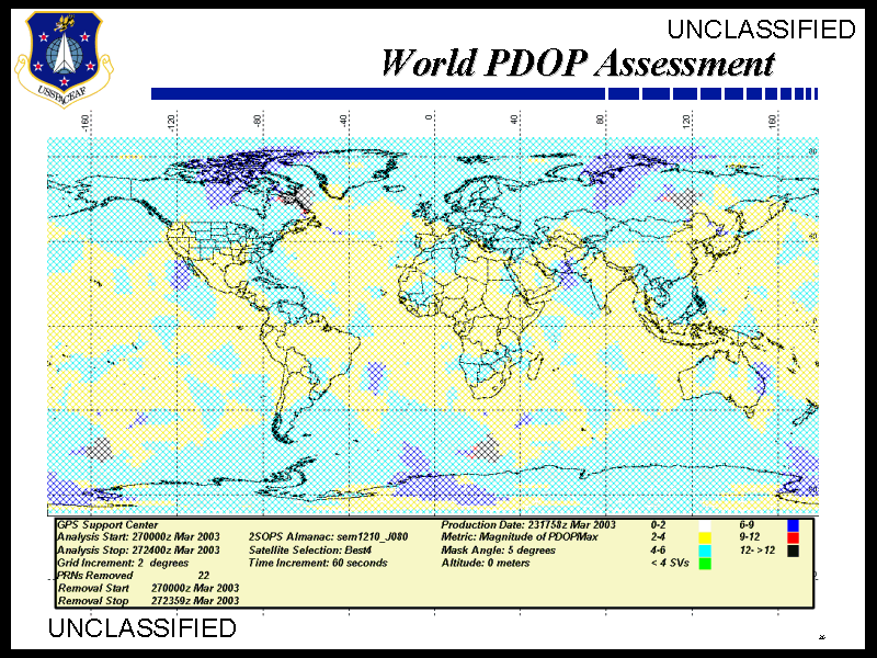
GPS is having problems
There are many areas in the world that are having problems with GPS but its not due to jaming, its due to the fact that there isn't a full constilation up. PRN 22 went dead a while back and hasn't been replaced. The current plan is to spread out the sats in that orbital ring (the B plane) to help fill up the gap but that will result in more outages in more places for short times compared to the current 1/2 hour outages seen directly in the flight path. The NavCen are recomending that you change your mask angle to 5 degrees if its set higher (many people use 15 degrees).
Right now you can see the problems on this map (mirrored here). The black areas are where GPS isn't going to give a 3d position and the red areas are where it wont get a 4d (3d+time) fix. The dark blue will have issues if any part of the sky is blocked. I don't think I've seen the GPS status this bad for a long time. Maybe its time to launch a few new navstar sats. -
Checking the official resources...It's an interesting discussion, but doesn't look like it's going to happen. The article they're referring to is just some German auto club that says the thing maybe it could happen when the war starts. Hardly authoritative.
The official sites to monitor if you're worried:
www.igeb.gov: The IGEB is a senior-level policy making body chaired jointly by the Departments of Defense and Transportation. Its membership includes the Departments of State, Commerce, Interior, Agriculture, and Justice, as well as NASA and the Joint Chiefs of Staff.
Right after 9/11/01, they posted (still there) this: "GPS Selective Availability (SA) has not been used since its deactivation by the President on May 1, 2000. At that time, the United States Government stated that it has no intent to ever use SA again. There has been no change in this policy."
http://www.navcen.uscg.gov/gps/default.htm is the official source for notices to civilian GPS users about schedule satellite outages, etc. They have nothing related to S/A being turned back on, and they certainly would if it were going to happen.
We can jam or dither the civilian code over the theater if we need to.
-
Try the USCG Navigation Center
For all your GPS news and status.
http://www.navcen.uscg.gov/gps/default.htm -
Re:GPS test equipment
The GPS protocol is indeed published in full. The military grade GPS uses decryption keys which are not published, but with the degradation currently turned off, there is no advantage in using the military signals.
It is perfectly feasibly to build your own GPS simulator. You'll need a good head for maths, signal theory and RF electronics though... That's why the ones you buy cost many thousands of dollars. The simulated signal can emulate the real GPS signals well (including multipathing, doppler etc) so it is not really feasible to differentiate the two.
-
Re:Redundant Title
Where did you get that? The official documentation defines GPS as "Global Positioning System".
-
Re:Selective Availability
Curiously, the web page for civilian users of GPS is under uscg.gov, but the references to it in the GPS book by Hofmann-Wellenhof (Fifth Edition, 2001) give the address as uscg.mil. Did the Coast Guard get changed from a military agency to a civilian one?