 Slashdot Mirror
Domain: noaa.gov
Stories and comments across the archive that link to noaa.gov.
Comments · 2,602
-
Re:Early warning
You seem to have missed the most cogent lesson of this disaster - there is no early warning system in the pacific either.
You mean there's nothing like the Pacific Tsunami Warning Center?
Perhaps this recent disaster wasn't in the Pacific. -
Re:NEIC: Why didn't you warn about the Tsunamis?
Maybe because the NEIC hasn't studied Indian Ocean Tsunamis and didn't know what was likely to happen? Maybe because the countries in the area haven't installed any equipment to tell NEIC or anyone else what was happening? Maybe because it isn't the NEIC's job to issue such warnings? (The Pacific Tsunami Warning Center knows more, but the Indian Ocean countries are not participants.)
-
Re:day after tomorrow
"Day After Tomorrow"
Tornado Warning in Los Angeles today
Snow advisory in Southern California today -
Lots of hype, poor science
This is what the real experts think about this. The topic of the mega-tsunami is at the end of the FAQ. So
read it and learn something.
Note that one could point to a lot of active oceanic volcanoes and pose a similar threat level if one considers a tens of thousand of years time frame.
Another side note: When I was in grad school, I was the TA for one of the committee members. -
Astroid hitting earth vs lightning strike
The odds this object will hit the earth are 1 in 56,000
The odds that you will be hit by lightning are 1 600,000
Now how do you feel -
No Tsunami Warning from the NOAA warning CenterThis report (reproduced below) from the Pacific Tsunami Warning Center sounds weird when you know how terrible the Tsunami was on the other side.
Basically, it says "THERE IS NO TSUNAMI WARNING OR WATCH IN EFFECT.".
Yes, of course, there was no tsunami in the region this warning center is responsible for. But who writes these reports? Is it sensible to just write "no tsunami warning", without specifying that it's a different story on the other side, in the Indian ocean? Wouldn't people writing these reports be supposed to be aware of it?
Anyway, that report, while it may be technically correct for it's region, sounds really weird to me.
Since the link is for the "latest report", and will change over time, here is the complete text of that page:TSUNAMI BULLETIN NUMBER 002
PACIFIC TSUNAMI WARNING CENTER/NOAA/NWS
ISSUED AT 0204Z 26 DEC 2004
THIS BULLETIN IS FOR ALL AREAS OF THE PACIFIC BASIN EXCEPT
ALASKA - BRITISH COLUMBIA - WASHINGTON - OREGON - CALIFORNIA.
.................. TSUNAMI INFORMATION BULLETIN
ATTENTION: NOTE REVISED MAGNITUDE.
THIS MESSAGE IS FOR INFORMATION ONLY. THERE IS NO TSUNAMI WARNING
OR WATCH IN EFFECT.
AN EARTHQUAKE HAS OCCURRED WITH THESE PRELIMINARY PARAMETERS
ORIGIN TIME - 0059Z 26 DEC 2004
COORDINATES - 3.4 NORTH 95.7 EAST
LOCATION - OFF W COAST OF NORTHERN SUMATERA
MAGNITUDE - 8.5
EVALUATION
REVISED MAGNITUDE BASED ON ANALYSIS OF MANTLE WAVES.
THIS EARTHQUAKE IS LOCATED OUTSIDE THE PACIFIC. NO DESTRUCTIVE
TSUNAMI THREAT EXISTS FOR THE PACIFIC BASIN BASED ON HISTORICAL
EARTHQUAKE AND TSUNAMI DATA.
THERE IS THE POSSIBILITY OF A TSUNAMI NEAR THE EPICENTER.
THIS WILL BE THE ONLY BULLETIN ISSUED FOR THIS EVENT UNLESS
ADDITIONAL INFORMATION BECOMES AVAILABLE.
THE WEST COAST/ALASKA TSUNAMI WARNING CENTER WILL ISSUE BULLETINS
FOR ALASKA - BRITISH COLUMBIA - WASHINGTON - OREGON - CALIFORNIA. -
Re:Difficult to detect / prevent
Hawaii has an air raid like tsumani warning system along its shores. There are tsunami detecting buoys anchored way offshore in deep water and the motion of the buoys will indicate an arriving tsunami.
Here's a link at the National Oceanographic and Atmostpheric Administration:
http://www.publicaffairs.noaa.gov/grounders/tsunam is.html -
Re:This is Geek news? Well ...
In Hawaii, they have a system of warning sirens along the coast to warn people of tsunamis. Such a system ought to be more widely deployed in earthquake-prone regions.
-
Re:Wind-power considered harmfulThey gain energy while out at sea, and then lose it when they pass over land. All the stuff on the land (trees, mountains, etc.) causes the winds of the storm to dissipate their energy.
Actually, the reason hurricanes lose energy over land is the same reason they gain energy at sea, they are gigantic heat engines. Hurricanes form when an area of low pressure and wind shear is over waters above 80 F. The low pressure causes the hot, humid air from the ocean to converge together, which pushes it high into the atmosphere and causes thunderstorms. The horrific winds of hurricanes are caused by the coriolis force acting upon the extreme convergance of air. Trees and small things less than 500 ft would mainly affect the wind gust speed by compressing and deflecting the air around (although I'm not sure what a wind farm would do). Mountains however would rip apart a hurricane. Hurricanes lose energy whenever they don't have a nice fuel supply, which is why hurricanes, even though they form in the Pacific, never hit California with it's 70 F waters. More info over at the NOAA.
-
Re:AdBlockWeather.com is soo last millenium. Assuming you live in America, try www.noaa.gov. They offer point forecasts (within a 5km area), no ads, and you've already paid for them via your tax dollars.
While I love the thought of using the weather underground for weather reporting (it seems like Open Source Weather Forecasting,) I haven't yet mustered up the energy required to figure a proxomitron filter to block the dozens of ads that litter their site. Until I do, the NOAA is still my first choice.
-
Really?
More of a libertarian, really, which increases my credibility.
In what way? By your naievté?Oh, right. By the fact that the Libertarian plank is "government is corrupt and evil, and corporations are good and benign, therefore we need to deregulate all corps and then we can sue them if they go bad"? Sure, that will stop corps from taking shortcuts to make a profit. Oh, and if the company gets caught, they won't use their economic/legal power to reorganize into a sue-proof company, because only government is evil, right?
-
Re:Weather Market
Raw data is available.
http://www.emc.ncep.noaa.gov/data/
http://weather.gov/noaaport/html/noaaport.shtml
Competing predictions are available, generally for a price however.
Example: http://www.saic.com/omega/
-
Re:Weather Market
TFA doesn't specify which data they're publishing, but after digging around the NOAA broken links, it's apparent that only forecast data are to be published. However, current conditions data are already published from a variety of sources, including the ones that show up in my GNOME Evolution "Summary" page. So this data really is most helpful in establishing a "baseline" against which to measure other forecasts. I expect the NOAA current conditions data will also be available. I'm really most interested in seeing the NWS "Heat Stress Index" stream come online, for an app I've had designed since they published their science behind the data 3 years ago.
-
Another bouy network
There is also another useful network of fixed bouys run by the NOAA at the National Data Bouy Center. They have bouys fixed at certain locations off the coasts and they record wind velocity and direction, swell height and period, air temperature and pressure and water temp. Things like wind direction and velocity can be very useful for people on boats out in the oceans, and the history on the site let you understand prevailing conditions of a given area. So if you friend says the waves were 5 feet overhead, or we had 15 foot swells out on the boat last weekend, you can actually check. You can even call a number on our cell phone and read data the bouys have collected.
-
TXT format is better than DOC.
I don't want my damn weather information in XML format. I want it in Microsoft Word format.
That is an open format with lots of documentation, and it will never go out of style...
Plain text is a lot better than Word as far as simplicity and portability, and METARs are currently available in Text format on the NOAA Server. -
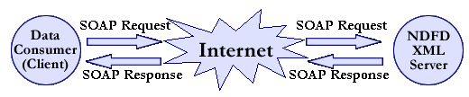
What Will Kill The Internet...
Contrary to today's poll, virii, spam, and backhoes will not kill the internet--but SOAP will. (For proof, see this image from this story's article)
-
Lat, Lon, and Elevation
...are listed in text files on the NOAA server for Stations idenfied by a 4-letter ICAO and Stations identified by a five letter synoptic code. If your city has a major airport, it should be in one of those files. Elevations are in meters.
-
Lat, Lon, and Elevation
...are listed in text files on the NOAA server for Stations idenfied by a 4-letter ICAO and Stations identified by a five letter synoptic code. If your city has a major airport, it should be in one of those files. Elevations are in meters.
-
Re:Why SOAP
They seem to have several different types of XML formats including RSS and XML in addition to SOAP.
-
Re:What's my lat and alt?
Yeah, you are right... that's the only information I need to chunk out a quick program running off the feed.
Speaking of the feed...here's the URL that contains the actual XML information:
http://www.nws.noaa.gov/forecasts/xml/
I guess they didn't post it on the front page to decrease the slash effect. -
Re:Odds Are Against It
It's kind of like those bacteria and tube worms thriving on the ocean floor in sulfuric acid at 300C. Drop their temperature below 150C, and they die.
*If* there were anything living on Mars in the first place, it would die long before we ever knew it got here.
But hey, anything to keep us safe from the Martian threat. Somebody's been watching too many bad scifi movies.
-
Re:free weatherbug?
-
Re:free weatherbug?
-
Re:free weatherbug?
-
Re:great, but how about distribution?
YUP! I would take this opportunity encourage everyone to sign up with your local NWS office as a spotter. All it takes is usually a rain gauge, a phone, and a few training classes. And let me assure you, your calls are invaluable to the people at the field offices!
Every time I call in, no matter how minor the event, they are always appreciative. The greater the density of people who call in, the more accurate the forecast, and the more warning time in a severe weather event. -
Re:NOAA & EAS
I completely agree. Even if you don't live in a tornado-prone area, tornadoes can strike with little or no warning. In fact, I was a small child when the somewhat-famous Manitou Springs tornado hit. Manitou is a MOUNTAIN resort town, so naturally tornadoes are rare, so say the least...
Luckily noone died in that tornado, but imagine my fright as a small child running inside not knowing what that thing roaring up the road was... On the plus side, I have become a hardcore weather nerd as a result, even a skywarn-trained spotter. And I can tell you that my weather radio has been invaluable! -
Re:The system works!!!
Yup, I can vouch for that. While I am not a broadcaster, I am a hardcore weather nerd. I visit the local forecast discussion daily. It offers the details that you simply cannot get anywhere else. During the spring/early summer months, the forecast discussion pages offer a *gold mine* of information on where the severe weather will be. Depending on how closely the models agree with eachother, I can usually get enough advance notice to make an eight hour drive to see some action.
-
Already been happening
"NOAA will make its data and products available in internet-accessible, vendor-neutral form and will use other dissemination technologies, e.g. satellite broadcast, NOAA Weather Radio, and wireless, as appropriate"
Has been internet accessible for years http://www.noaa.gov/, and if you crawl around enough you can find where they put the raw data feeds and make an app that reads them (seem to be the same ones that go to the automated 'voices' that broadcast NOAA Weather Radio, yes, the Weather Radio network that has been around for a long time, heck, I have scanners and CB sets that have Weather Radio switches). The only one I don't understand directly by this is 'wireless', as the weather radio and satellite networks are wireless, and wireless internet and cellular telephone access is publicly available. -
Re:The system works!!!
You can find this stuff pretty easily from NOAA if you take a look around. I'm a broadcaster, and I look at these every day when I'm preparing my forecasts. We get prepared weather from a commercial provider, but I find it to be severely lacking, because the community my station serves has weather that can be quite different, depending upon where you are. During the winter, you can go from just rain to a foot of snow within 40 miles.
Here's the site I visit every day. Take a look at things like the "Area Forecast Discussions." While they're a bit cryptic to read, they give you a better picture than the limited local forecast. -
NOAA & EAS
It can never be emphasized enough how utterly valuable a SAME equipped weather radio can be. They do not just allow you to get up to the minute weather reports, but they also act as your first warning of any kind of serious emergency in your area.
Warning sirens are only intended to notify people outdoors, and TVs and radios are only useful if you are awake, the unit is on and you are within earshot and paying attention at the time.
When NOAA or an emergency management agency (NOAA allows them to utilize the system without running the transmissions by them first) sends out a warning message, it is proceeded by what sounds like intermittent static. In fact, the system is sending out a burst of number sequences that are decoded by SAME equipped radios that compare the number sequence to that which the user has previously entered. If they do not match, the radio ignores the message, if they do match however, a generally ear-piercing alarm sounds while the radio interprets the alert code and displays the corresponding text message before the computer voice announcement (or real person if the situation warrants it) from the NOAA station begins to broadcast. The process takes about 10 seconds (this is to give you a chance to get closer to the radio before the voice warning begins).
Here is a complete list of all of the emergency codes
They are not as cheap as a clock radio, but they are worth every penny. I'm still astonished when I come across people who live in tornado-prone areas who don't buy them despite their financial ability to do so and their fear of dangerous weather. -
The system works!!!Slashdot even got an honorable mention in the NOAA writeup (third paragraph)!
I'm happy because my concerns were addressed. I was afraid that the proposed policy was going to give commercial interests the ability to reqeust the NOAA discontinue a service without review, meaning that if weather.com didn't like the ability of the NWS to issue point forecasts they could behind-the-scenes ask for it to be ended. The modified policy now states they will "Establish... orderly processes for seeking input and suggestions to create, modify, or discontinue products and services".
It's a cool feeling to be a part of a process that actually seems to have worked to our advantage for a change.
-
Re:For a little more tech detail
GOES 10 and GOES 12 also registered an anomoly at the same time. http://sec.noaa.gov/ftpdir/plots/satenv/20041128_
s atenv.gif -
Well, it cuts both ways.While the old incentive tune is certainly a familiar one here on
This link shows you that by sharing protocols on the web, it is a fact that researchers can save money and even get better results than the crap that is being pushed in a lot of these kits. In fact, the profit motive typically acts contrary to the ends of good science.
And speaking of on-line protocols, this is what I expected to see from something called "BioForge." I'm not dismissing them as it's fairly clear they're still in the starting stage, but it's worth noting that there are already many open protocol sites on the web with incredible amounts of information. A quick google for "biological protocols" turns up quite a few. -
Television Meteorologist
I'd have to disagree with the Television Meteorologist listing.
In New England, most local television news weather forecasts are overseen and reported on air by actual meteorologists, unlike other parts of the country that have untrained "weathermen" (like southern california). In smaller TV markets, or weather is much more stable, or even on radio, you might as well read off government supplied weather forecasts.
They are well paid for TV. (however if you are not on TV, meteorologists get shafted in terms of pay, unless they work as consultants -- usually environmental consultants dealing with air quality issues.)
Also, those guys are instant celebrities around these parts.
Snow predictions are one of the harder predictions to make. These guys basically have to choose between various computer model predictions, and sometime they are far off.
However, my recommendation is don't trust a forecast longer than 24 hours in advance.
-
Re:Religious radicals?To put it another way, there are quotes in the Bible that state that the Sun "rises" and "sets". Does this mean that a geocentric solar system is the correct interpretation of the Bible?
Whoa! The National Weather Service has "sunrise" and "sunset" on its web site. I think you should send them an email with the correct information right away! They obviously believe in a geocentric solar system.
Could anyone tell me exactly how Genesis and the theory of evolution are incompatible?
-
Link
This may be of interest to some: http://sec.noaa.gov/pmap/
Contains forecasts and historical data plots.
Phil -
Re:Your Tax Dollars At Work.
Your argument whilst superficially attractive seems to be based on jealousy greed and ignorance.
For example, in related geographical, geological and political news
http://www.antenna.nl/wise/index.html?http://www.a ntenna.nl/wise/570/5419.html
It seems that the final cost of your national nuclear weapons defence program also offers you the choice of drinking radioactive water or paying your tax dollars to keep the Colorado river clean.
To summarise
"U.S. DOE announces plan to relocate Atlas Moab uranium mill tailings
During a ceremony, held on January 14, 2000, high on a cliffside bench above the tailings, Energy Secretary Bill Richardson announced a sweeping plan for relocating the Atlas Moab tailings away from the bank of the Colorado River. With this plan, Richardson is addressing the fears of Los Angeles water officials that the water supply for millions of Southern Californians would be threatened if the 10.5 million short tons of radioactive dirt were left on the flood plain of the Colorado River.
Two big hurdles remain in the drive to clear away the pile, left near Moab by Atlas when it went bankrupt: funding the multi-year project, which the DOE estimates would cost $300 million, and transferring authority from the U.S. Nuclear Regulatory Commission to the DOE. (Deseret News / Salt Lake Tribune Jan 15, 2000)"
"A bill ordering the Atlas uranium mill tailings dug up and moved from the flood plain of the Colorado River near Moab was approved Oct. 12, 2000 by the U.S. Senate. The measure, which passed the House on Oct. 11, now goes to the president for his signature. (Salt Lake Tribune, Oct. 13, 2000)
President Clinton signed the bill on Oct. 30, 2000."
"President Bush has included no money in his 2002 budget to clean up the abandoned uranium mill tailings site near Moab, Utah, where federal officials have estimated 16,000 gallons of water containing radioactive uranium tailings are leaking into the Colorado River each day. Despite legislation passed by Congress last year giving the Department of Energy authority to begin cleaning up the site, the department has set aside no specific funding to get started. (Las Vegas Review-Journal, April 24, 2001)"
So your deffinition of private property rights includes opting out of being an American - presumably developing nuclear weapons in your garage capable of persuading the Soviet Union to surrender in the cold war. What you are suggesting is that you want to opt out of your own society. You may have perfectly good reasons to do so but I think you will find that you are in a minority of one - or maybe I'm wrong and you can persuade everybody that drinking radioactive water is good for you.
Whilst you consider your options, here is a beautifull view of the waste heap to watch whilst you think about it.
http://www.crh.noaa.gov/gjt/Moab.html -
Re:Its not about power density, its about economic
so..
you are saying with '40% efficient multijunction concentrators' that you are
a) turning 40% of available solar flux
into electricity, and covering 100% of the
available ground in doing so.
b) avoiding the storage, transmission, and
conversion costs. (to either put said
electricity into a battery or into coal,
oil or hydrogen)
c) providing 10 MW to 10 GW base load power
capability.
Sorry if I don't believe you. First, 964kWh/m^2/year means that you are extracting 110 W/m^2, when in Kansas the total amount there is about 140 W/m^2 - which means you are getting 80% efficiency. Reference please.
Secondly, even if you could get that for one solar cell, perhaps you can tell me of the technology which allows you to saturate 100% of the area with these cells, and the storage technology that has been developed which allows you to assume that the 954kwH that you cite goes into 100% efficient use.
You seem to think that users will somehow instantly use the energy as it is collected rather than needing to store it.
If you really are 'in the field' so to say, you know that people's usage of energy at home is very sporadic, with low needs at some points and high needs at others, and that the times solar collection is done hardly coincide with the times people use the energy.
My arguments with your numbers are that you seem to assume that conversion, transmission, and storage costs will simply 'go away' when we use solar power, because it is 'distributed'.
You will grant, won't you, that solar power is not strong enough to say, run a TV, computer, stove, and heat at the same time in a given domicile, won't you? And that it is not strong enough to run a high-rise building?
If so, then your 954kwH (which I think is wildly optimistic) will rapidly go down. And that 65% of the solar energy will need to be transmitted to where it is needed, as well as stored, given that 65% of the electricity usage is non-residential?
So, taking this into account -
Say there is a 60% penalty in converting energy into something storable, and collecting that energy (natural gas, etc), and a 60% penalty in storing the energy for usage someplace else. Say that there is a 9% penalty for transmission. And say there is a 20% penalty for maintaining the infrastructure. And say that even though you are using 40% efficient cells, you are really getting 20% efficiency (because you cannot saturate the ground with solar cells, but can only use them in about half the area). Then, in an average (170 W/m^2) power density solar area:
170 W / m^2 *
3 * 10 ^ 13 kilowatt hours / 90 kwH / m^2 =
3.3 * 10 ^11 m^2 in km^2 =
330,000 km^2
So, ok, not the size of alaska, but the size of italy. And about 60% the size of texas, which is fairly close to my other estimate. And still greater than the whole world's current energy infrastructure (reference; energy at the crossroads, page 340) (reference for kansas power density: earth radiation budget satellite erbs)
I think you should realistically consider the losses from solar energy rather than assume 'oh yeah, we're getting x kwH from solar, hence we're going to be using x kwH because its distributed!' Its exceedingly naive to think that you can get 100% a conversion rate for anything, and of course the larger the collection fields, the larger the maintenance costs.
And of course we haven't even touched the manufacturing costs and/or EROEI of these solar cells. I've seen everything from
Like I said, every time I think about your numbers, I see -
Re:Kyoto
While I agree that we should all work to improve the environment and reduce the environmental impact of global industry, President Bush and the Kyoto Protocol hardly have anything to do with increased hurricane activity, it is astonishing to see such psuedo science bantered around as fact.
Well, maybe not so astonishing on slashdot...
-
Re:Kyoto
Yeah, because having multiple category 5 hurricanes ripping apart the south-eastern US every year is so much cheaper. Look at what a cost saver it was this year...
-
Re:gods fucking damnit.
Either sign up on the Aurora Alert mailing list or keep an eye on the realtime Kp index wherever you are. If it's night where you are now and you're not in the middle of a bloody thunderstorm then gtf out and look for auroras.
And if you're willing to pay $4.95 per month for it you can get the information brough to you by subscribing to the spaceweatherphone
Have fun down under - I heard you guys raise to hell and descend to heaven.
-
Re:Also a good show in the Northern Hemisphere
wow, slashdot is getting really good with up-to-date info... I spent 2 nights ago wathcing the display cover the sky here in Idaho... last time I checked that too was in the Northern hemisphere.
on a more technical note, austrailia isn't alone in all this crap. As far south as Idaho we can see aurora at the KP index of 9... as of this post, it's at 10. -
Weather
The National Weather Service has quite a few interesting and useful feeds. Including Hurricane Info and Current Observations.
-
Re:A better link...
And those at the game likely won't be able to see the eclipse due to clouds.
-
Re:Keep Both
Yes, but there is a subtle difference in the types of technology. The manned submarines that reached the deepest part of the ocean were thick skinned vessels with no manipulators or propulsion. Alvin was submersible with a large glass window, manipulators, and self-propelled, allowing the ability to examine specimens.You can see how the technology has evolved; lighting and propulsion migrate to the sides to maintain a hydrodynamic shape. The visual field expands to 180 degrees at each end.
-
Re:Must have been quite powerful
The 121.5 MHz (as well as 243 MHz) Distress call response is being phased out, and the newer 406 MHz call is becoming a more accepted (and used) standard.
See the official NOAA Press Release (PDF) for deteals. -
Re:The 'Little Ice Age'
There is a nice graph here showing the slight increase in the sun's average output during periods of high sunspot activity.
It appears there is an increase of 2 watts/m^2 at the earth's distance from the sun.
-
Re:Well - US does similar things...
-
Re:Forest fires?Mt. St. Helens is in the great NorthWet... I mean NorthWest, not part of the dry West.
http://www.cpc.ncep.noaa.gov/products/analysis_mo
n itoring/regional_monitoring/palmer.gifFire danger is low.