 Slashdot Mirror
Domain: noaa.gov
Stories and comments across the archive that link to noaa.gov.
Comments · 2,602
-
You have never been to Niagara Falls, have you?
but in the long run the lake will evapourate, making the climate in the region less stable (water holding a lot of heat is one of the main reasons the earth has such a (relatively) mild climate) with hotter summers and colder winters, leading to the requirement of more heating in winter and more air conditioning in summer... brilliant
Lake Erie and Lake Ontario have about the same surface area. But Lake Ontario is much deeper and so has a greater volume. I have links here to charts showing the temperatures, at various depths across various slices of Lake Erie and Lake Ontario.
Note that Lake Erie is much warmer. But most of the water in Lake Ontario came from Lake Erie? Why is it so much colder? It cools off in the winter time. It takes water from the Niagara River six years before it flows down the St Lawrence.
If, for the sake of argument, Rochester, Kingston, Hamilton all used deep lake cooling, and they all grew so much that they exhausted the Lake's deep layer, Lake Ontario would still not evaporate, any more than Lake Erie evaporates away to nothing.
Yes, there are deep areas of Lake Ontario that have been at 4 degrees celsius for a long time. How long? Since the last ice age? The glaciers covered the entire Great Lake basin a few tens of thousands of years ago. So that is how long a unique deep lake water ecosystem would have had to evolve.
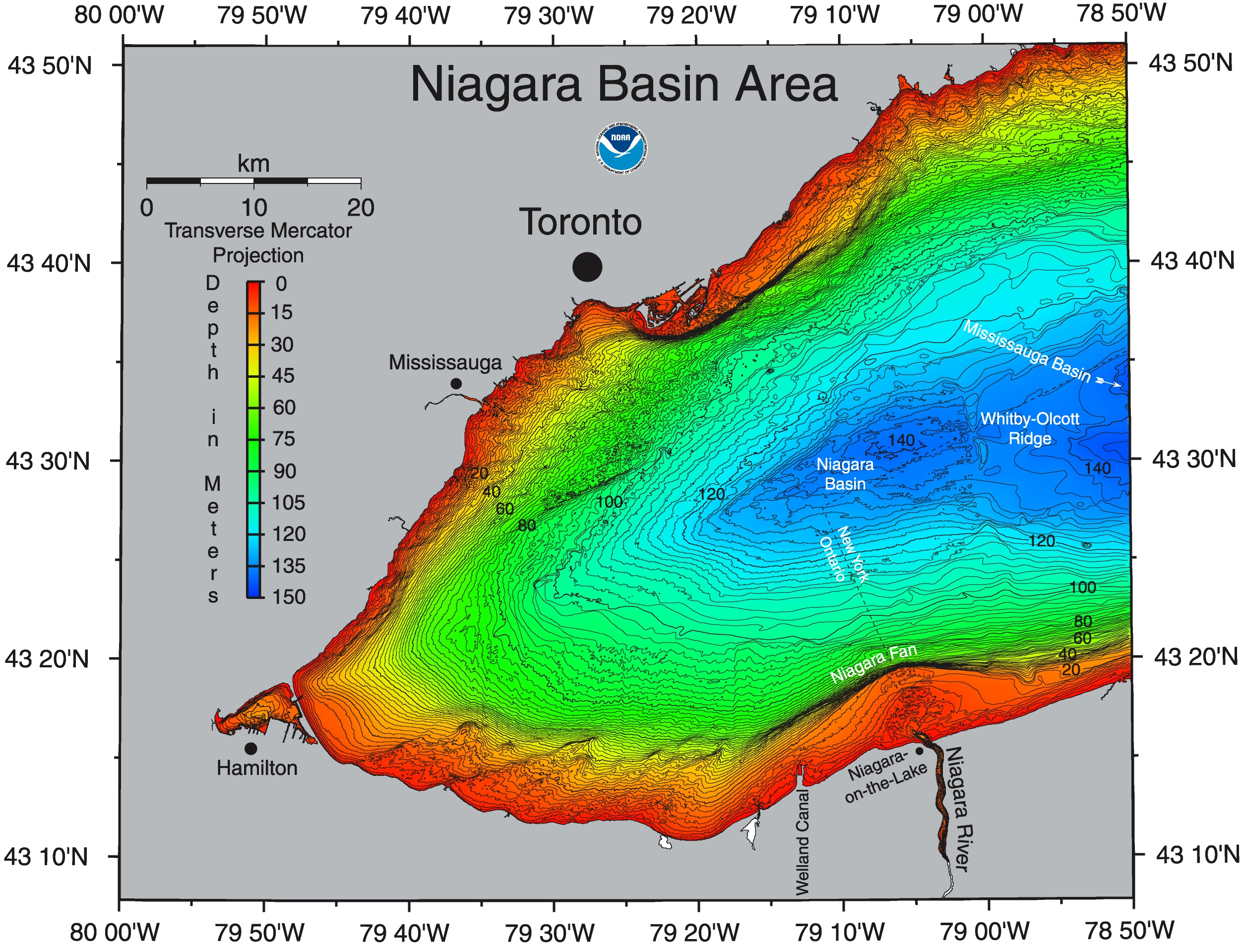
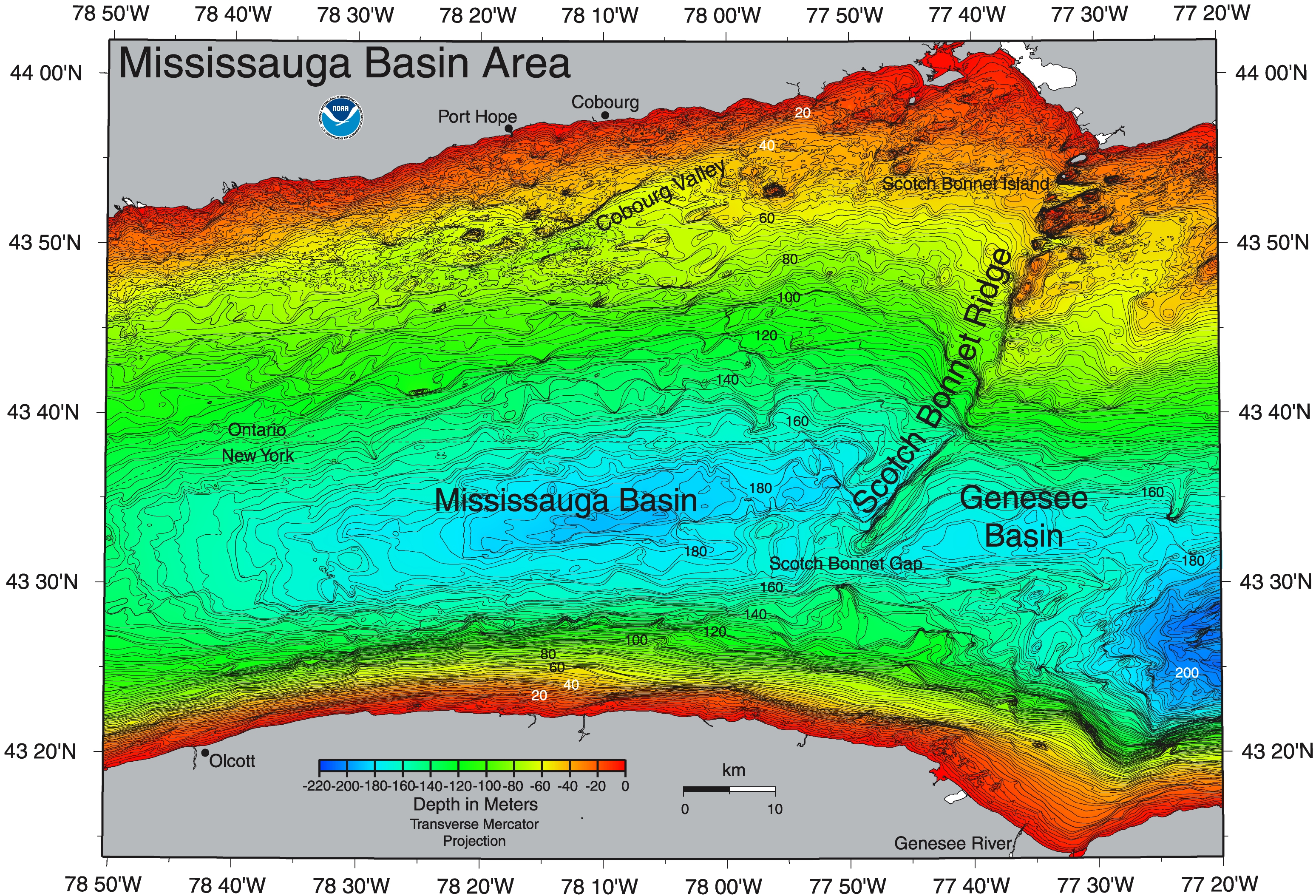
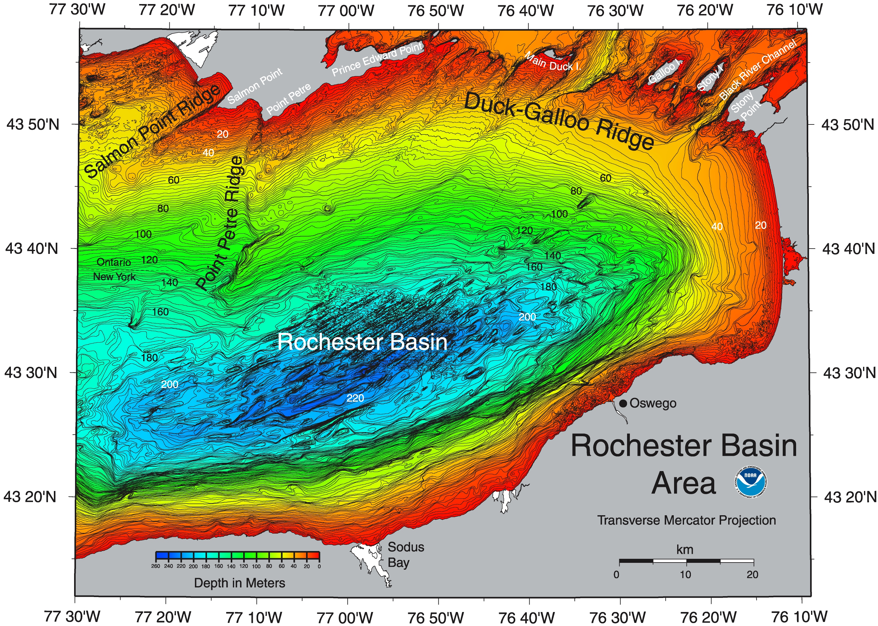
How much water would the cities have to draw from the deep layer to use up all the cold layer? I don't think you understand how deep the Lake is, and how great its volume. Look at these three maps. West Centre East. So, lets say the deep layer is currently something like half to one third of the volume of the lake. The cities would have to use up the equivalent of the flow of two or three niagaras worth of water in order to drain all the deep cold water.
So long as our winters continue to get cold enough for the lake to cool to 4 degrees the cold layer gets regenerated every winter.
I think it could be argued, if Global warming every gets bad enough that using deep lake cooling exhausts the cold layer in mid-summer that, since we have the infrastructure in place, we use it every summer until it is exhausted. What about the cold deep lake water ecosystem? I am all for preserving interesting, unique ecosystems. But I doubt that a few tens of thousands of years is long enough for it to become interesting and unique.
-
You have never been to Niagara Falls, have you?
but in the long run the lake will evapourate, making the climate in the region less stable (water holding a lot of heat is one of the main reasons the earth has such a (relatively) mild climate) with hotter summers and colder winters, leading to the requirement of more heating in winter and more air conditioning in summer... brilliant
Lake Erie and Lake Ontario have about the same surface area. But Lake Ontario is much deeper and so has a greater volume. I have links here to charts showing the temperatures, at various depths across various slices of Lake Erie and Lake Ontario.
Note that Lake Erie is much warmer. But most of the water in Lake Ontario came from Lake Erie? Why is it so much colder? It cools off in the winter time. It takes water from the Niagara River six years before it flows down the St Lawrence.
If, for the sake of argument, Rochester, Kingston, Hamilton all used deep lake cooling, and they all grew so much that they exhausted the Lake's deep layer, Lake Ontario would still not evaporate, any more than Lake Erie evaporates away to nothing.
Yes, there are deep areas of Lake Ontario that have been at 4 degrees celsius for a long time. How long? Since the last ice age? The glaciers covered the entire Great Lake basin a few tens of thousands of years ago. So that is how long a unique deep lake water ecosystem would have had to evolve.
How much water would the cities have to draw from the deep layer to use up all the cold layer? I don't think you understand how deep the Lake is, and how great its volume. Look at these three maps. West Centre East. So, lets say the deep layer is currently something like half to one third of the volume of the lake. The cities would have to use up the equivalent of the flow of two or three niagaras worth of water in order to drain all the deep cold water.
So long as our winters continue to get cold enough for the lake to cool to 4 degrees the cold layer gets regenerated every winter.
I think it could be argued, if Global warming every gets bad enough that using deep lake cooling exhausts the cold layer in mid-summer that, since we have the infrastructure in place, we use it every summer until it is exhausted. What about the cold deep lake water ecosystem? I am all for preserving interesting, unique ecosystems. But I doubt that a few tens of thousands of years is long enough for it to become interesting and unique.
-
Is Chicago out of luck?Your link is interesting. I have one too. It took me a minute or two to figure out this page. The map of lake michigan in the lower right hand corner has five lines drawn through it. The five color coded temperature charts each illustrate the temperature at various depths through a slice of the lake. The one closest to Chicago is slice "A", correct?
There was an interview on the morning news yesterday with a guy who is a big fan of this technology. The interviewer asked him if this technology could be used in other cities on the Great Lakes. Yes, he said. There were various cities where it could be used. Rochester and Milwaukee were two examples he offered. But, he said, it could not be used in Chicago. Presumably because Chicago doesn't have easy access to a deep cold layer.
Here in Toronto we have always taken our water from deep in the lake too. As you can see from this map the depth drops precipitously just off Toronto Island.
The American fan of this technology was Alec Baldwin, the actor.
The interviewer next asked him if any of those other cities were considering following Toronto's example. He replied that he was flying to Chicago that afternoon to make a presentation.
-
Lake Ontario is very deep
In this case, we're heating a very cold (and potentially very isolated part of the lake)
You don't have to guess. Google is your friend. Here is a map. Note: The inlets are just inside the green zone. The deeper part of the lake doesn't seem to be broken up into isolated pockets.
Note: The lake gets a lot deeper.
-
Acronyms and Terms ExplainedI have a few of these:
GPS = global positioning system (but you knew that)
ephemeris calculation = modeling a satellite's orbit based on a handful of numbers, demonstrated by http://ssd.jpl.nasa.gov/eph_help.html
RINEX = Receiver Independent Exchange Format, http://www.ngs.noaa.gov/CORS/Rinex2.html
SLOC = source lines of code
COCOMO = an obsolete software development cost model http://www.jsc.nasa.gov/bu2/COCOMO.html
-
Re:Cool phishing detection quizThe www4 only shows that it's a subdomain of usbank.com, though. That shouldn't prove anything unless usbank.com leases its subdomains to irresponsible phishers.
Examples:
-
Re:tornado sirens too?
Wrong. This is a mesoscale discussion. A mesocyclone is the rotating part of the cloud base. And IIRC, they usually issue tornado warnings whenever something is rotating, just to be safe... (even if there isn't a tornado there's going to be hail and high winds...)
-
not only unencrypted but a public spec
the EAS digital signal is the same signal that the National Weather Service (NWS) uses on the National Oceanic and Atmospheric Administration's Weather Radio (NWR).
-- www.fcc.gov/cgb/consumerfacts/eas.html -
not only unencrypted but a public spec
the EAS digital signal is the same signal that the National Weather Service (NWS) uses on the National Oceanic and Atmospheric Administration's Weather Radio (NWR).
-- www.fcc.gov/cgb/consumerfacts/eas.html -
All the more reason for a Linux BIOS.As long as the BIOS is proprietary, they have all the keys, and the locks.
The community needs a concentrated effort to pressure the hardware companies for a Linux BIOS whose page appears to be missing. The last time I read something on the Linux BIOS, perhaps here on
While the hardware manufacturers (esp. motherboard manufacturers) want to keep their code secret for competitive reasons, they are also part of the manufacturers that banded together to oppose drm several years ago in Congressional hearings, even at one point during those meetings threatening to buy out Hollywood if it became necessary (should be Intel rep comments to Valenti, during Commerce Committee hearing on drm, over an issue of letters exchanged, and delayed responses between the MPAA and the tech industry, over the drm issue). At that point, tech was generally opposed to drm, with exceptions on companies who were in a position to benefit from drm (Miron's company, one of the drm solution providers, Microsoft, and other drm solution providers), while hardware manufacturers such as Phillips, and other entertainment device companies opposed, as well as other (mp3, Rio style) hardware sellers opposed.
If the MPAA/RIAA is given the control it is seeking (a cash register button replacing the record button, as previously reported:Finally, you state that you do not wish to limit the ability of consumers to record over-the-air radio broadcasts. Instead, you apparently want to force them to buy what they have received for free since Fleming and Marconi first made it possible for consumers to hear news and music over the public airwaves.
As you know, we have long been concerned about content owners seeking to change the "play" button on our devices to a "pay" button. At least you have addressed the semantics by suggesting new devices come equipped with a "buy" button.**Excerpt of letter to Cary H. Sherman, President, RIAA, from Gary Shapiro, President & CEO, Consumer Electronics Association, 4/15/04, responding to a fax, by Cary H. Sherman to Gary Shapiro, at 14:30, 4/14/04, with this attempt at greasing the wheels:
We also point out that a lack of content protection will forever preclude a myriad of new business models that could [insert hush money offer here] benefit your members [end insert of hush money offer here] as well as other interested parties. For example, device manufacturers could provide "buy buttons" that would offer consumers the ability to quickly and easily purchase music that they hear on the radio. Indeed, iBiquity has said that it would like to offer to consumers, for a fee [as opposed to free], on demand weather and traffic reports. The same opportunity could and should exist for music, the bread and butter of radio broadcasts.
Sources
), they'll need control over the BIOS. That's why Microsoft is pushing so hard in this area, and why the Linux community must push back just as hard, and get the Linux BIOS.
5 second boot times were promised with a Linux BIOS. I'm still waiting. For the BIOS, and for my computer to boot up.
Another recen -
IronIron is the limiting factor for most ocean biomass growth. A pound of iron in any form added to the ocean can yield new life enough to sequester anywhere from five to fifty tones of carbon.
North America is also a huge carbon sink.
-
Updated Space Weather information
No, it's not bigger then the X17 event last October.
Remember, you can always get up to date information from NOAA's space weather site, including the page that has updated X-Ray images of the sun, auroral maps, and measurements of the magnetic field among other things. -
Re:Semi-serious?It may very well be the case that lightning bolts are being cast by an omnipotent being. Our understanding of the natural causes of lightning suggest nothing either way.
Please look here for an explanation of how lightning forms.
-
Re:OT: Clouds as bacterial colonies?
The problems with cloud seeding are huge, and yes, I will admit that we don't totally understand the dynamics of what makes rain. We do have a pretty good idea, and some very good theories, so when you propose something fantastic and from left field away from the current theories, you must have some incredible evidence as well. Raw speculation simply won't cut it, and we are talking raw basic science here. This is how scientific theories form.
There are incredible amounts of energy that are released in storms, and in particular clouds have to be heavily saturated and ready as well in order to rain. Cloud seeding is attempting to bypass the normal weather mechanisms and cause a cloud to rain when normally it wouldn't.
For example, some people suggested (even here on
Do you really think that one small plane with a few drops of iodine or other mineral would really make that much difference? You might make a huge difference if you "seed" a few miles before it normally would, or increase the amount of rainfall by about 1%. The questions then would be: How can you tell if it made a difference? Is it really worth the money when you can obtain more water elsewhere? Is this preventing rainfall in areas that really need this water? What other climtological effects does rain seeding do?
There are some very competent scientists working on weather forecasting and study of the physics of weather. Except for the Global Warming issues, there really isn't that much that is controversial regarding what they do, and they don't really get paid that much either, unless they are working for a major market television station. Put away your tin hat and read what real scientist are saying about this topic. If you study this in detail and can prove organic production of clouds, including going up in a Cessna. It wouldn't be hard, and you can even keep the airspeed rather low. Even a sail plane would work if you wanted to make sure that engine noise and exaust would keep bacteria away. If you capture relatively large numbers of organic lifeforms in clouds, and can prove that the clouds themselves form nurseries for these organic lifeforms, I might be considerably more impressed.
Lifeforms in the clouds of Venus or Jupiter would be the next place to look if you can even identify lifeforms that spend most of their lifetimes in clouds themselves. You might even get a NASA grant if you can show even preliminary results for something like this. -
Re:Does this mean..
DMS does get oxidized, eventually, to sulfates (i.e., one of the acids in 'acid rain'). Is this important? Depends on how much is being produced this way, obviously, but according to this estimate the overall sulfur emission from oceanic sources (plankton, etc.) is about 20% of the emission from human activities (globally; it's more like 10% in the N. hemisphere, much higher anthropogenic emissions - mostly coal burning).
So the evil death plankton's sunscreen is some kind of factor in acid rain, but not the biggest one. -
Links for the copy/paste impared:
-
Re:you don't understand tidesthere are 2 low tides and 2 high tides every 25 hours so that's 1. coming in, 2. going out, 3. coming in, 4. going out... every 25 hours, all of which the turbines harvest
Aha. I'm with ya' now. Here is a nice graph that lays it out pretty clearly.
-
Some of the fun ones have already been posted.The US Census has tons of great info, as does the USDA Nutrition Database. Mortality stats gathered by the CDC are fun in a morbid kind of way.
There are some great collections of historical climate data out there for free. Here's a source for the Western US (a similiar compilation for the entire US would be great). Some earthquake data can be found here.
Heck, just enter "raw data" into google, along with your topic of choice, and have fun.
-
NOAA
Go to the NOAA Web Site and download all the weather data from your area going back many, many years.. its facinating to take the datasets and plot the ranges in temperature, humidity, etc..
-
Re:NASA Funding
Why are we not giving them more funding?
Its always hard to justify givng money to pure science. Its a noble endeavour, but how can you calculate the ROI of knowing the composition of rocks on Mars? Would most people care? If Cassini didn't go to Saturn until, 30 years from now, would it make any difference.
We should always have a well funded space agency, but don't get outraged when there are cuts to the program.
NASA still gets $15.5 billion this year ($91M less than last year). And where is that money going? Well NOAA is getting a $190M increase in funding. Different scientists, but still science research, with more likely more immediate impact. -
A lot of disinformation from Slashdot on this one
First, Barry Myers is not the president of AccuWeather. Second, this request is not coming from AccuWeather but rather from the CWSA which includes all significant commercial weather companies including the Weather Channel and various broadcast meteorologists. (Barry Myers happens to be head of a committee there). Third, CWSA is not recommending the removal or discontinuation of anything, but rather requesting a review of the policy (read: law) currently in effect but is being ignored by government employees. Rather than offering to review the policy, the NWS has offered only to discontinue the policy entirely, giving them free range to spend your money on whatever they want... if this happens, expect to see (more) plasma screens in NWS offices and more inane projects like the Science Sphere (maybe a good idea if done by some rich kook but not if done with money taken out of my weekly check).
-
Comment on the NOAA site not just here.
Any comments about the need for government data to be availible to the pulbic (or vice-versa if that's your view) should be sent to the comment page listed in the article. Discussion on
-
Keep it free!
I don't think anyone should have to pay ANYthing (other than the obvious portion of one's normal tax dollars that go to support NOAA/NWS) to get weather info!
It never ceases to amaze me how greedy and unprincipled the private sector can get. On the one wing, there's a ton of links on sites like Yahoo!, MSN, ad nauseum, all pointing to weather forecasts that are crammed with advertising.
On the other wing, it only takes a little common sense to go straight to the source for weather data that costs nothing, is as accurate as our current level of science can manage, and is not cluttered with distracting ads.
What's going to be next? An attempt to privatize, and charge for, the VHF weather radio broadcasts? Oh, the boaters and fly-boys will love that one...
Sheesh....
-
So do something about it.
I fully agree. And, since the article on the FP of
[The following text is public domain and may be used without attribution]
I have just read over your proposed policy change, as well as Barry Meyer's response, available at this address: http://www.weatherindustry.org/BARRYMYERS-AMS-0318 04.doc . I must say that I cannot possibly disagree with Mr. Meyer more. The NOAA is a publicly funded institution providing data that could never possibly contain anything that would be classified.
Accordingly, I am of the firm belief that any data collected by the NOAA should be made available for public (i.e. the general population, not merely other agencies) as soon as is practicable, in whatever format is easiest for the public to consume.
Mr. Meyer, and for that matter, the rest of the private weather sector, need to realize that they should never be the sole beneficiaries of the collective tax dollars spent each year by the U.S. in providing such a vitally important service.
I am tempted to make the comparison of the difficulties that the RIAA and MPAA are currently having with the digital revolution. Mr. Meyer and the PWS need to update their business models, not attempt to change the law.
[End of Public Domain Section] -
Been here before
This isn't the first time that Accuweather has tried to limit public access to NWS products. See the National Hurricane Center website for some information on Accuweather's attempt in 2003 to block the NHC from issuing hurricane advisories in mobile format (WAP/WML):
http://www.nhc.noaa.gov/tpcwap_responses.shtml
Pay particular attention to the two letters linked near the top of that page.
I would strongly encourage everyone to submit comments to the NWS on their Fair Weather Policy. The comment period ends June 30.
-
Re:SUBMIT YOUR COMMENTS!
According to that page, you can also just e-mail fairweather@noaa.gov.
-
Re:SUBMIT YOUR COMMENTS!
According to that page, you can also just e-mail fairweather@noaa.gov.
-
Re:Middlemen
I made an observation about the weather and its importance to daily life around the world one day when I tried to discuss the weather with the locals in the Philippines. (EH?) was the response. It never occurred to them that paying much attention to the weather was important.
They get weather there and some times quite severe, but I found that the reason was simple. They knew that certain days of the year it would be dry others wet and stormy. If the wind was blowing a certain direction at a certain time of the year, it told them what the weather was.
I suppose this is an over simplification but simply stated most of the world gets weather by the calender and by location. Weather in most of the world is pretty much boring. NORTH AMERICA and most specifically the Central Mississippi River Valley gets some pretty amazing weather. It is neither predictable by time of the year nor is it something that you can know by location. You cannot know it by wind direction and you cannot know it by other current conditions. It can bet amazingly dangerous or troublesome.
Rain in this region of the USA and southern Canada can be accompanied by most dangerous condtions. Rain in this area rains Fertilizer as well (Nitrate) which is natural in origin. As such weather is to those of us living in that area a pretty important thing. To the rest of the human race, they have a hard time understanding our preoccupation with it.
The logic of allowing US Government Weather Forcasting to be open to the public is an American Construct. It stems from our understanding that WE own our government. This is counter to the logic for most of the rest of the world. We are despite accusations to the contrary an Anti-Colonial force. The Colonial forces want to reoccupy our land and they are attempting to upset the logic so that they can force the middle men into weather just as they do in Europe and Asia. They are attempting to make everything even that which we have already bought and paid for into property we have to pay rent on. This is what the discussion is about.
The NWS for basic Info has a lot more to add to the forecast stuff than you might think. If you want to see my current conditions here they are. Clicking on the side links can give you a hint of the level of data that we expect for free.
-
SUBMIT YOUR COMMENTS!
Be sure to submit a comment through ths page.
Here's the comment I submitted:
As a government agency, the purpose of the NOAA is to serve the public. Data which has been generated or collected using tax dollars belongs to the public and should be freely available to the public.
Information provides the greatest benefit when it is freely available and most widely utilized.
Thus far the NOAA has had a "non-compete" policy. I have no doubt the NOAA is receiving pressure from special interests to maintain that policy and to withhold data from the public. Business is a good and valuable thing when it provides the public with needed services, however the government should NOT be protecting unneeded redundant services at the direct expense and detriment of the public. The government should not be creating an artificial scarcity of information. The public should not have to pay a second time for information it has already obtained through tax dollars.
- -
National Weather Service funding...We the people, pay for the National Weather Service in the form of our tax dollars (2003 $800M, 2004 $824M). "The National Weather Service provides weather, hydrologic and climate forecasts and warnings for the United States, its territories, adjacent waters and oceans." (blurb ripped from Washington Technology.com)
I see no reason that we should have to pay for Accuweather to make a pretty graphic or the like. By opening up the data on the Internet you provide researchers, hobbyists, and tinkerers with a means to get up-to-date and accurate weather information easily as well as historical data.
NWS also talks about their Information Quality guidelines here - detailing their information and what is available.
Who knows maybe someone will develop a Weather@Home model which runs on the same principle as SETI@Home. It would be pretty cool to start doing climate models outside of the governments and universties Research labs...
-
Re:Should we have to pay twice to get weather foredon't understand how anyone is paying "twice". Please explain?
The National Weather Service, a part of NOAA (National Oceanic and Atmospheric Administration), is funded by taxes. It's already been paid for. The need for accurate weather information is extremely important for the military. Because it's almost as important for civilian use, the information is made available to the public.
Pilots, farmers, businesses and municipalities need this weather information, and in the U.S., weather is almost an obsession (Weather Channel, anyone?) There is no national or continental weather service in Europe; private pilots have to pay for information, usually in the form of two daily faxes. This means that European pilots have to know even more about weather than their American counterparts because they must be able to predict conditions, whereas U.S. pilots can get up-to-the-minute information.
In a nutshell, the Private Weather Sector want to be a middleman, themselves continuing to get the information for free and then charging others for what they (the public) have already paid for.
- Pay government (taxes) for weather information.
- Only one private group has access to this information
- Pay private group to give you this information
If you still don't see it, imagine "EduCorp". EduCorp cuts a deal with the local government to provide schooling for children. The locality stil pays for everything, but EduCorp acts as a middleman. Only EduCorp subscribers can send their kids to these public schools. You pay taxes for schools and then pay EuCorp for th right to send your kids there. All clear?
-
but wait there is more...
fishing in my weblinks....
unreal cave
projection links and type breakdowns
uaeu cave
elumens products are droool
fakespace
vrml 3d projection
not quite cave.... this is 3d projection
this one is further leading.....
io2tech -
Arctic climate changeOne of the big worries about the Arctic is climate change. Much of the ecosystem relies on the presence of ice, and this ice seems to be disappearing. See fig 16.3 of the IPCC report for a timeseries going back 100 years. In the past few decades we have had adequate measurements of wate temperature in the Actic, and it appears to be rising; see the diagrams in a recent essay at the NOAA site, for example.
As ice changes, so does the ecosystem. Polar bears cannot walk on water, for example.
There are also global consequence of Arctic change that worry climate scientists. For one thing, there is a nonlinear feedback loop since ice has a high albedo. Thus, ice reflects solar radiation back to space, which keeps the system cool. But water has a much lower albedo than ice. This yields a nonlinear feedback loop. Melting ice creates open water, which absorbs more heat, which melts more ice. There was a time when USSR scientists suggested we could open up a northwest passage through the Arctic simply by painting the ice black, setting this feedback loop into action. Of course, if the ice melts, navigation will be easier through the Arctic. Traffic may avoid Panama and go through a more direct route. Part of this traffic could be oil tankers, which can run aground, causing great damage to a system already damaged by the climate change.
-
Link to a previous expedition
Canada Basin has already been checked out in a mission in 2002 which you can read about here. I guess this time round it's so they can have a jolly good look. I wonder if they'll find any aluminium cans or plastic bags at the bottom
As one reader pointed out, exploring the deep ocean is harder than space. I guess that's why they felt compelled to put a flag at the bottom. -
Re:Coast To Coast AM - (Art Bell, George Noory)
It's just a little something I've been playing around with in my spare time.
It does use cookies to store the current settings, so when you go back to the page, it should be the same as when you left it.
The tiles for the photo and topo views are USGS images, sourced from Microsoft's terraserver-usa site. For the blended mode, they are generated as needed from the map and the photo, then cached locally on the server.
The address lookup is based on geo-locator using a database based on Tiger 2003.
Place lookup (and the landmark overlay) are based on both the USGS GNIS database, as well as the NGS Benchmark database. It has 2,504,693 entries in the database right now.
The Geourl overlay is based on geourl.org's XML feed - it's cached locally, and only polls geourl.org when data expires from the cache.
Dnsloc is based on DNS LOCation records - I ran a crawler a couple of weeks ago on every site listed in DMOZ, and found just over 1,000 sites that listed location info in their DNS records.
There are a few other overlays that are about ready, but I haven't put them on the main page yet - letting users add annotations, readings from weather stations, readings from streamflow stations, etc.
Basically, I want to take every web accessible database I can find containing information that makes sense when displayed geographically, and make it into an overlay. -
Re:Nah, You Don't Need Webbed Feet, Linus!
I've lived in Oregon for more than a few years, and recently moved to Memphis. I believe the reason people in Oregon are so used to rain is that they don't get the kind of thunderstorms we get in the south.
It would be more accurate to say that it drizzles in Oregon constantly - it's spread out over a long time and doesn't have much intensity.
In the mid-south, it's sunny most of the time - we rarely get much cloudy days over here, and it's really hot compared to Oregon. However when it does rain it tends to come down harder, and we occasionally get storms like nothing I've ever seen in Oregon. When I lived there, I never carried an umbrella, either. In the south, there have been times where I was afraid of getting out of the car because the rain and the lightning was coming down so hard. Several inches of rain will fall in a couple of hours, and flash flooding occurs. The hardest rain I have ever seen was in Louisiana, by the way - real wrath-of-God stuff, it's no wonder they have more fundamentalists here
In Oregon, the actual amount of rain may be higher, but it's spread out over a longer period of time and is not as intense.
Believe it or not, Portland is not the rain capital of the world.
Compare - Portland Memphis -
Planes Hit By LightningI was chasing storms in a plane as part of a research project to study sprites, jets, and other middle-atmosphere lightning. Our plane got into the upper region of a small storm, and we were hit by lightning. We had video cameras going and they didn't even hiccup. Check out a frame grab (the next frame was completely saturated). That pod in the image is the end of our wing (I think this was the Westwind II, but it may have been the Jet Commander).
Another amazing video is of a plane getting hit by lightning at a Japanese airport--check it here.
Bottom line: planes can be just like a big hydrometeor from lightning's perspective.
-
New Mexico? No.But, anyway- New Mexico has a very high density of lightning, second only to parts of FL
According to this flash density map, New Mexico has to get in line behind Louisiana, Alabama, Mississippi, Georgia, Florida, South Carolina, and a handful of other states.
-
Re:Mmm... weather...
A PLETHORA OF SFC AND UPPER LEVEL FEATURES BEGINNING TO SPAWN
Translation (as I can't find this text in Google, I'm assuming IA is Iowa, and that this was a recent advance bulletin regarding weather moving towards Illinois):
DEEP MOIST CONVECTION IN NRN IA, WILL EVOLVE INTO A MCS LATER
TONIGHT AND LIKELY MOVE INTO THE NRN PORTIONS OF THE CWA.
CONCURRENTLY... wtf is MCS? CWA?A lot of surface and upper level features beginning to spawn deep moist heat transfer in northern Iowa will evolve into a group of thunderstorms later tonight, and likely move into the northern portions of the area concerned by this bulletin.
See "A Comprehensive Glossary of Weather Terms for Storm Spotters," by Michael Branick, located here. Further resources are here and here though this list - and the terms they cover - are by no means comprehensive.
Take pretty much everything with a grain of salt, and try to cross-reference, as all terms aren't defined at all of the references, and some of them aren't what you're looking for. For example, Branick doesn't list "CWA," and AVWX lists it as "Central Weather Authority." In context of the bulletin you posted, "CWA" means "County Warning Area," something none of these references mention. A County Warning Area encompasses multiple counties, often across several states. Go here and find the color-coded region on the map that represents your closest big city; that's your approximate CWA.
Chicago would be LOT (Lockport, airport code) in Central Region HQ, or http://www.CRH.noaa.gov/LOT . Bookmark that, if you haven't already, and watch the county map the next time there's severe weather in the area. Reload every couple of minutes, and you'll know about any watches, warnings, or statements affecting local counties. Fascinate your friends and family - and who knows, possibly save their lives - by IM'ing "Tornado Warning!" 2 minutes before the sirens go off and 3 minutes before the TV jockey passes the warning along. Fuck the TV weather, noaa.gov is the shit.
I will admit to sharing your perplexity as to why NOAA doesn't issue more "English" warnings. The only thing I can come up with is that in some cases, time is of the essence, and keeping the transmission as small as possible makes it faster to type and transmit. I'm not sure that quite explains it, though; as when EAS activation is requested for a tornado warning here, all of the cooperating radio stations broadcast a robotic text-to-speech voice reading a quite English version of the warning.
The bulletins are translated into understandable English at some point before they're broadcast to the public, so why they can't be written that way to begin with, I'm not sure. Maybe it's because NOAA/NWS has outsourced to India? >:) -
Lightning Season in AlaskaThe heading states "sorry west coast", but Alaska is the farthest west state in the U.S. (also the farthest north, and east), and it most certainly is lightning season here. You can view the ground strikes on a map online.
In my area, (Alaska Range) as well as the Interior and the Brooks Range of Arctic Alaska all have very severe storms; I have witnessed them, and the resulting forest fires, firsthand. I have recorded some fierce storms, with lightning, marble-size hail, strong winds, and once I swear was a tornado (I'm from the midwest originally, and know what a funnel cloud looks like).
-cp-
-
Re:lightning..
Although I don't have a link or reference to the article (other than I believe I read it in Reader's Digest), there have been several cases of individuals struck by lightning indoors. One instance that stands out in my mind, was a story of a woman, in a basement who was struck by lightning while washing clothes, and reaching towards a glass block window, where her detergent was sitting.
"Can I get struck by lightning when I'm indoors?"
NWS Lightning Safety: Indoors
-Mikey P