 Slashdot Mirror
Domain: usgs.gov
Stories and comments across the archive that link to usgs.gov.
Comments · 1,416
-
Re:Global Warning
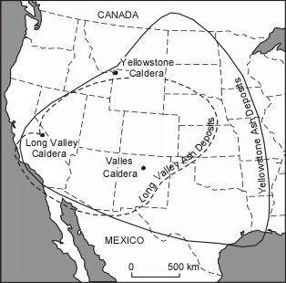
small amounts of volcanic ash might only irritate your lungs, but if a supervolcanic eruption took place, it would likely throw up tremendous amounts (~1000 cubic miles) of tephra/pyroclast, the finest particles of which could circle the globe and remain suspended in the atmosphere for years. if you're immediately downwind from such an eruption, you'd be breathing in heavy amounts of what is essentially microscopic shards of broken glass for weeks or months.
archaeological evidence has been uncovered showing that the mass deaths of plains animals 12 million years ago during a supervolcanic explosion at Yellowstone were due primarily to lung disease from volcanic ash inhalation. even many animals that survived the initial ashfall were still killed by the ash stirred up by their own movements or wind.
-
Re:Sensationalism at its best
This also does not raise any cause for concern. But there was cause for concern. There really really was.
-
Re:Too late
Except for the fact that the area that these earthquakes are occuring contimues to rise and tilt the lake south
Of course it's still building up to an eruption. I'm saying that every little earthquake swarm cannot be taken as a sign of imminent eruption.
Look for reports of venting gas, or even minor lava eruptions around the edges. Then run.
-
My favorite daily links (USGS)
Just thought I'd post these up again:
Main global earthquake map
List of EQs in the SouthWest
Display of drum recorders for the Southwest
Cheers and Happy New Years! -
My favorite daily links (USGS)
Just thought I'd post these up again:
Main global earthquake map
List of EQs in the SouthWest
Display of drum recorders for the Southwest
Cheers and Happy New Years! -
My favorite daily links (USGS)
Just thought I'd post these up again:
Main global earthquake map
List of EQs in the SouthWest
Display of drum recorders for the Southwest
Cheers and Happy New Years! -
Re:Global Warning
nah, it won't quite be that bad. most predictions expect the immediate danger zone to have a radius of 1000-1600km, with pumice & ash deposit probably covering all of California and most of the Midwest. but rather than being burned, most deaths/injuries will likely be caused by ash inhalation.
luckily, modern humans have the benefit of science and technology.given enough warning, most people within range of the volcanic explosion and subsequent lava/pyroclastic flow (70,000 to 100,000+ individuals by some estimates) can be evacuated beforehand. everyone else will simply have to stay in doors for a couple of days before they too can be evacuated outside of the ash cover area.
the USGS seems pretty confident that the YVO monitoring program will detect any premonitory indicators (such as emissions of magmatic gases) of any such impending disaster. and studies indicate that, if there is a volcanic eruption, it is not likely to be a caldera-forming supervolcanic eruption due to insufficient rhyolitic magma-storage to sustain such an event.
in the event that a caldera-forming eruption takes place, then yes the ash will probably circle the entire globe and lower the temperature in the lower atmosphere for a few years, and that can have a severe impact on the ecology of the planet. but it's certainly survivable. and the chances of such an event actually occurring is still statistically insignificant--contrary to what is often reported, are are not "overdue" for a supervolcanic eruption. (the mean interval between such eruptions is 710,000 years, not 600,000 years.)
if others are interested, you can read the USGS's report on the Preliminary Assessment of Volcanic and Hydrothermal Hazards in Yellowstone National Park and Vicinity (the actual report is in PDF format).
-
Some scientific perspective......courtesy the U.S. Geological Survey:
Fortunately, the Yellowstone volcanic system shows no signs that it is headed toward such an eruption in the near future. In fact, the probability of any such event occurring at Yellowstone within the next few thousand years is exceedingly low.
...
Lava flows and small volcanic eruptions occur only rarely--none in the past 70,000 years. Massive caldera-forming eruptions, though the most potentially devastating of Yellowstone's hazards, are extremely rare--only three have occurred in the past several million years. U.S. Geological Survey, University of Utah, and National Park Service scientists with the Yellowstone Volcano Observatory (YVO) see no evidence that another such cataclysmic eruption will occur at Yellowstone in the foreseeable future.
(emphasis mine)
As for that "several million years" figure for a devastating explosion of the kind TFA is describing, consider that the United States as a nation is still less than 250 years old. I'm not saying it can't happen, but the idea that "it hasn't happened in a long time so it must be ready to happen now" is just a popular Las Vegas delusion.
-
Re:Too late
Except for the fact that the area that these earthquakes are occuring contimues to rise and tilt the lake south
-
Recent Earthquake map
Map showing recent earthquakes is over here http://earthquake.usgs.gov/eqcenter/recenteqsus/Maps/US2/43.45.-112.-110.php
-
Proper disposal?
What precautions and regulations would these so called garage hackers take when disposing of such experiments? Sure one could say that the garage computer hackers of the 70s, took all the solder and buried it in the backyard or through it in the trash. But what is the potential of the environmental impact of a couple of circuit boards going in a landfill versus someone pouring down some modified bacteria? Also, don't forget in the 70s we were pitching TVs into the garbage.
Before you go off the handle, go do some research on "invasive species" that are occupying and dominating areas like the Florida everglades. Foreign Fish and Eels are ending up in the everglades because people are dumping their home aquariums into the local streams http://sofia.usgs.gov/publications/fs/swampeel/
Btw, dumping aquariums aren't the only issue, this type of issue extends to how people dispose of Prescription Medicines http://www.medicationdisposal.utah.gov/
-
Re:Global Warming
May I make a slight correction?
1. Volcano's and things alike emit more C02 gas then the entire human race.
sure do. and for a long time, before the advent of industrialization, the climate has experienced only moderate fluctuations even with all that volcanic co2. then along came escalades and coal plants and massive human-engineer deforestation projects that when added to all that volcanic co2, it tipped the balance to a general warming trend.
Actually, volcanoes eject less CO2 than human activity. Considerably less than 1 percent of anthropogenic CO2 levels. The Hawaiian Volcano Observatory has actual numbers posted http://hvo.wr.usgs.gov/volcanowatch/2007/07_02_15.html
Volcanic activity also puts out a whole bunch of pollutants such as SO2 that cause localized effects but may or may not influence global climate change.
It's a bit nit-picky, though, and shouldn't take away from your point. You are completely correct that volcanic CO2 has been variable in the past and has not demonstrated the climate fluctuations we're seeing now.
-
Re:Please no climate modelling!
I have to admit I am sceptical about blindly believing in global warming. I used to in the past however I've become a little smarter since then I can not see any hard observations for it, especially when volcanoes pump out 26 times more CO2 per year then all of humanity on the planet
That's not even remotely true. Volcanic CO2 emissions are about 1% of human CO2 emissions (see here). Where did you get the rather specific, and wrong, factor of 26?
Maybe you'd see the hard evidence if you spend a little more time reading about it, since you appear to have some peculiar misconceptions. I recommend Kerry Emanuel's essay "Phaeton's Reins", David Archer's undergrad textbook, and the IPCC AR4 report for technical details.
-
Re:A myth.
A nitpick: Your second link is a graph of SO2 emissions, not CO2. You're not comparing the same things. However, if you look at the bottom of the page you linked to you may have discovered this which in fact supports the argument you were trying to make.
-
Re:A myth.
Because volcanoes put more carbon into the air that humans will in our entire existence on this earth.
That's nonsense. CO2 emissions by volcanoes (including those underwater) are less than 1% of current anthropogenic emissions. There is no serious doubt that the recent (during the last 150 or so years) increase in atmospheric CO2 is primarily due to the burning of fossil fuels. Simple mass balance shows that we emit about twice the amount of CO2 needed to explain the increase (the rest vanishes into natural sinks, mostly the oceans), and isotopic analysis shows that the carbon in that extra CO2 is of fossil origin.
I can understand being skeptical about global warming, but what I cannot understand is blatant ignorance about the basic facts
-
Stop F**king!
A good reason to either stop f**king or start taking those pills that the white girls do. Jeez looks like ya'll running out of room out there in the Maldives.
-
Re:A myth.
-
Re:A simple question
Numbers from the USGS.
If East Antarctica melts, we're looking at a 64.8m rise in sea level.
-
Re:It's dog eat dog in MMOs
Clean water, by the way, is a simple matter of pouring it through activated charcoal.
http://ga.water.usgs.gov/edu/wwvisit.html
Because, you're going to drink it again.
http://en.wikipedia.org/wiki/Water_supply_network -
Re:This is nothing new
Exactly, I am a propagation engineer and have been working through this very challenge for 20+ years. There are a multitude of commercially available products out there to create an area coverage.
I use TAP (Terrain Analysis Program) and it is quite expensive ($20 K with all of the bells and whistles). Almost all of the data sources I use are available at no cost. LULC (land use,land classification) for vegetation types I modified TIA TR8 (revised) to calculate vegetation losses more accurately into the GHz spectrum.
Terrain data in the Shapefile format is available at http://seamless.usgs.gov/website/seamless/viewer.htm. I even pull down SRTM (Shuttle Radar Tomography Mission) data for elevation info.
There are several different propagation models and each has it's own advantages and disadvantages; Longley-Rice, Bullington, Okumura, Okumura-Hata-Davidson, etc.
Generally I can get accurate results around 90% but you need to also incorporate rain attenuation losses using the Mendhurst, Ryde, CCIR or Crane methods. Atmospheric absorption losses, climate (thermal noise) and terrain roughness.
With WiFi you can never be certain what the antenna polarization will be of the end device (horizontal or vertical), depending upon how the device is held, this can introduce an additional 20 dB of losses).
Base station antennas have specific radiation patterns and nulls, reflections off of structures (multipath) can be additive or subtractive. Knife edge diffraction can cause problems. Even the polarization of trees (trunks are usually vertically polarized, branches are usually horizontally polarized). All of these things are potential losses.
A propagation model will give you some idea on if a system will work. It is no replacement for field testing. To depend solely upon any software propagation tool is a recipe for dead spots and project creep (when you suddenly find out you need 30% more Access Points and you have committed to a certain service level to the customer).
If you want to give it a try, download the demo of TAP from SoftWright http://www.softwright.com/ it will only work in the Denver area but you can try some of the tools out for path analysis, coverage studies, area coverage (best server, aggregate networks), Inter-modulation, antenna patterns and the losses/ gains of transmitters, receivers, antennas and feedlines.
BTW, I am just a customer. I have no vested interest in SoftWright or TAP.
-
Re:2 - The Great Flood (Where are all the Unicorns
Yes, indeed, scientists observe California move a few inches and then extrapolate that movement and come up with utter crap stating that in x number of millions of years California will be next to Alaska. They assume (believe) this rate will be or has been constant for all that time. They do this backwards in time also.
Once rock is forced up to the surface, it doesn't weather the same as rock still in liquid (or solid) form under the surface.
I'm no geologist, and I came up with that just off the top of my head. Why would they assume constant movement? They can't, so they have to correlate those observations with other sources of data to come up with any kind of extrapolation.
We have far more ways of gathering data on the plate movements than just taking California's movement over a few years and extrapolating to millions of years.
It can be observed that the continents sort of fit together like a huge jigsaw puzzle. What cannot be derived from this however is the time scale over which this continental drifting took place. This assumed, not measured or observed. Assuming that rate of present processes can be applied over vast time scales may be correct, but it is nevertheless an unprovable assumption. Most processes observed in nature today are neither linear nor constant.
It is quite conceivable, that when the earth was younger and hotter, the underlying layers where more fluid. This would mean that the continents moved much more easily and faster than we observe them to be doing today.
Sources?
Follow-up: I did 30 seconds of research and pretty much confirmed my guesses -- the plate tectonics concept sat on the shelf for years because of lack of solid evidence... until the 1950s, when we developed methods of mapping out the ocean floor, which held a lot of clues.
-
Re:refund
Except in California, where EULAs are on some very shaky legal ground.
EVERYTHING is on shaky ground in California http://quake.usgs.gov/recenteqs
-
Re:If Afghanistan was for oil, where was the oil?No real oil?
Since the first oil field was discovered in Afghanistan in 1959, more than 150 million barrels of oil (mmbo) reserves and more than 4,500 billion cubic feet of gas (bcfg) reserves have been identified, using Soviet methodologies and technologies, in 29 fields in the Afghan portion of the Amu Darya and Afghan-Tajik basins (fig. 3). Only a very small portion of this reported resource base has been exploited. The country has not been well explored for oil and gas potential using the latest techniques. There is enormous opportunity for further discoveries to add to Afghanistan's energy resource base. That resource base is essential to the economic development of the country.
We know it's there, and we assume there is more, maybe far more than we know, simply because the last to search were Soviets 40 years ago.
-
Re:Solve the problem, for pete's sake
No seismic activity meaning, of course, that it's located in a dormant volcano in one of the most geologically active states in the United States.
Nowhere near civilization, of course, meaning within 100 miles of an urban area containing over 1,000,000 people.
Oh, and this nuclear waste is being transported by... fairy magic? Or, are we just going to use the railways and ship the waste through a bunch of urban areas? Either way, this should be fun.
If only we actually could recycle the waste instead of throwing it away or something... -
Re:Let me guess...
Neat - did you work for the USGS? Sounds like they are doing the same (or a similar) study. I just saw a press release (with video) about that the other day.
-
Re:Let me guess...
Neat - did you work for the USGS? Sounds like they are doing the same (or a similar) study. I just saw a press release (with video) about that the other day.
-
Re:Support The Municipality (We're Onto You)
Both are fed by a very large underground river that originates outside this county, and which there are zero efforts to "replenish" by anyone.
"Tertiary-treated municipal wastewater (recycled water) has been used to replenish the Central Basin in Los Angeles County for over 40 years." http://pubs.usgs.gov/wri/wrir034279/
Additionally, the "local water-management agencies" are also responsible for projects preventing "seawater intrusion into freshwater aquifers".
-
Re:Precisions on the summary
How about this? http://lima.usgs.gov/
-
Re:what the hell?
They have a Lahar warning system going in.
http://volcanoes.usgs.gov/About/Highlights/RainierPilot/Pilot_highlight.html
With Rainier your looking at an infrequent event.
With the Gulf Coast it has been hit several times in the
last few decades, Katrina just 3 years ago.Before that By Camille & Betsy, and now Gustav.
That is 4 major hits.
Again as in my previous post, I think building codes would
solve all of this once and for all.In most major cities around the US you cannot build in
the 100 year flood plain, and in Earthquake zones you
have to build to code.The same should apply to Hurricane prone areas.
Build to code, or build somewhere else.
Turn all of the Hurricane and Flood vulnerable sections
into a state park, or industrial land, do it over time
as time permits.The only other possible solution is build 3 story parking
garages with houses on top where the large tracts of destroyed
houses are now and make the houses out of steel reinforced
concrete that can take a 2x4 hitting them at 200 mph.Make it where all windows must have certified storm shutters.
Make Hurricane preparedness NOT optional, make it law.
It is like one poster said, you have the right to live anywhere
you want, but don't come digging in my wallet when your home
on the shore goes out to sea. -
Re:News for nerds huh?
Link from the summary: http://water.usgs.gov/waterwatch/gustav/
-
Re:News for nerds huh?
No, it is the USGS too. I'd tell you to turn in your library card, but then how could you improve your reading skills?
-
Re:pro-ID and anti-ID are both scientific
If mankind has evolved from apes, how come in the 5,000 years of recorded history
There are more than 5000 years of recorded history. History recorded dinosaurs 65 million years ago. As I told the reply above yours, the Clovis culture in North America is dated as around 13,000 years ago however the archaeological site Monte Verde on the southern tip of Chile is dated 1000 years before Clovis. Cro-Magna paintings in southwestern France are dated as being 20,000 to 10,000 years ago. Aztecs invented the calendar around 4236 B.C thus putting it as 6000 years ago.
If evolution is an on-going process, why are there not monkeys constantly evolving into hominids?
Why should primates only evolve into homos? Why can't they evolve into other species? Look at a tree of life, evolution loves diversity.
Shouldn't there be a continuum of species?
There could be one but a record may not be possible. A dead body left in the Florida Everglades won't last very long, not even the bones even if it's human. Guess what? They embalm people when they die to preserve the body. Even then though those bodies may not last thousands of years.
To me, this is just like the global warming scam
Here we go again. Another person who thinks they are more qualified than the thousands of climatologists who have concluded Global Warming is real. What makes you more qualified than all of them? Where did you get your PhD in a climatology field, and what field is it? And did you do any post-doc work?
Antartic ice shelf is about the same size as it was 100 years ago
Where's your proof? Even if the Antartic ice is the same size, and Larson B didn't break oh but it did off, that does not mean ice isn't melting elsewhere. I see your proof, if you provide any, with that from qalified scientists. For instance the Artic ice is near record lows. The glacier on Mount Kilimanjaro, which provides fresh water to millions of people in Africa, have almost disappeared. As have glaciers in the Andes of South America, which also provides millions with fresh water. Then there are the glaciers in Greenland. If there isn't warming how are all these glaciers melting faster than ever?
And when you read how Mann of the famous "hockey stick" chart cherry-picked and manipulated his data, and then refused to release the data for a number of years - well, that doesn't sound like science to me.
Where's your proof Mann cherry-picked his data? In this SciAm article Mann refutes some of his critics. For instance critics charge the hockey stick chart does not graph the Little Ice Age, yet that was a local not a global phenomenon and his chart was global not local. Only those who deny Global Warming continue to harp on stuff like this.
The Earth has actually cooled over the last 4-5 years
Citation.
To people like you there must be a conspiracy, however like those who deny conspiracies about JFK's assassination and 911 say, if there were a conspiracy how come someone hasn't come out and disclosed the facts? Why aren't the street lined with those assassinated because they tried to warn people?
Why should my children be denied this great history and literature in favour of "I Have Two Mommies"?
Why should my children, though I don't have any, be denied the great history in the "Analects of Confucius
-
Re:Quote from the Future
Let's skip the talking points, shall we?
-
Re:Quote from the Future
What were you trying to show with that link? Someone repeating a bunch of debunked talking points? Because that's what she's doing. For example, that "2000 acre" thing. The oil is not concentrated in one 2,000 acre area; it's in more than 30 deposits spread across 640,000 acres of Alaska's North Slope coastal plain (out of 1.5 million), which means stretching roads, pipelines, and other infrastructure that practically renders the area uninhabitable for large wildlife. Even if you only want to look at the "touching the ground" measure of how much land it takes up, the combination of oil infrastructure, drill sites, airports and roads, and gravel mines is *12,000* acres, not 2,000. No rivers in the North Slope? Um, BS. I mean, come on -- you think that all the water on the north side of Alaska drains all the way to the south? I could go on and on. This is a woman who thinks that an animal that spends most of its life hunting on ice flows isn't going to be adversely impacted by their imminent disappearance, and you're acting like she's some kind of environmentalist? Give me a break.
Actually it means horizontal drilling at safe distances below sea level.
It's not rocket science.
Department of Geology at Univ. of Wisconsin
http://www.geology.wisc.edu/courses/g115/oil/4.html
http://www.horizontaldrilling.org/Natural Gas Horizontal Drilling
http://www.greencarcongress.com/2008/01/researchers-say.html
Geothermal Conference on HD
http://www.nationaldriller.com/CDA/Articles/Industry_News/BNP_GUID_9-5-2006_A_10000000000000399698
NaturalGas.org
http://www.naturalgas.org/naturalgas/extraction_directional.asp
-
Re:Quote from the Future
What were you trying to show with that link? Someone repeating a bunch of debunked talking points? Because that's what she's doing. For example, that "2000 acre" thing. The oil is not concentrated in one 2,000 acre area; it's in more than 30 deposits spread across 640,000 acres of Alaska's North Slope coastal plain (out of 1.5 million), which means stretching roads, pipelines, and other infrastructure that practically renders the area uninhabitable for large wildlife. Even if you only want to look at the "touching the ground" measure of how much land it takes up, the combination of oil infrastructure, drill sites, airports and roads, and gravel mines is *12,000* acres, not 2,000. No rivers in the North Slope? Um, BS. I mean, come on -- you think that all the water on the north side of Alaska drains all the way to the south? I could go on and on. This is a woman who thinks that an animal that spends most of its life hunting on ice flows isn't going to be adversely impacted by their imminent disappearance, and you're acting like she's some kind of environmentalist? Give me a break.
-
Re:lol
-
I know you're joking
But no, you wouldn't like it if the state where most of your oil is located (yup, Texas) decided to become a separate country, believe me.
http://geology.usgs.gov/connections/blm/energy/o&g_assess.htm
Let alone if it was to become a separate Spanish-speaking country and tell the English speaking US citizens to get the fuck out.
-
Re:UAV missions more demanding that you might expe
http://afghanistan.cr.usgs.gov/oil.php Since the first oil field was discovered in Afghanistan in 1959, more than 150 million barrels of oil (mmbo) reserves and more than 4,500 billion cubic feet of gas (bcfg) reserves have been identified, using Soviet methodologies and technologies, in 29 fields in the Afghan portion of the Amu Darya and Afghan-Tajik basins (fig. 3). Only a very small portion of this reported resource base has been exploited. The country has not been well explored for oil and gas potential using the latest techniques. There is enormous opportunity for further discoveries to add to Afghanistan's energy resource base. That resource base is essential to the economic development of the country.
-
Re:it's you who is advocating massive change
there simply is no third possibility.
I think there are other possibilities.
1. Why doesn't anyone want to talk about the known increase in solar radiation over the last 30 years? AFAIK, we don't have numbers going back any further, but it seems fairly obvious that if there is more solar radiation entering the earths atmosphere, the climate will change.
2. Maybe we won't run out of oil because it isn't really made from dead trees and dinosaurs. I've been meaning to find some numbers, but I have a hard time understanding the amount of decaying organic matter necessary to create the 80+ million barrels/day of oil pumped from the ground in 2005. I know were talking about geologic time scales here, so I'd be interested in seeing some numbers about how many trees and dinos that adds up to.
I'd also be interested to find out how trees and dinos ended up 10k+ feet below the surface of the earth. Some of these are 35k+ feet (7+miles) deep.
3. I doubt there were many trees or dinosaurs on Hyperion or Titan, 2 of Saturns moons. Yet, they have pools of hydrocarbons, hmmmm.
Don't get me wrong, I'm not interested in the world getting so polluted that we can't breathe or grow food. I'm just concerned that global warming is really another scam to take more of my money in the form of taxes to "save the earth". If I remember correctly, when I was a kid, the big fear was we were going into a new ice age. Now we have the same data providing proof for the exact opposite hypothesis. Now get off my lawn.
-
It ain't gonna work
From the article:
The process of making lime generates CO2, but adding the lime to seawater absorbs almost twice as much CO2. The overall process is therefore 'carbon negative'.
1. To absorb 1 mole of CO2, you need 2 moles of CaO (one mole of CaCO is used to negate the effect of the production of CaCO), that gives is a ratio of 2:1
2. We are producing almost 30 million metric tons of CO2 per year from fossil fuels (and accelerating).
http://www.eia.doe.gov/iea/carbon.htmlThese numbers look suspicious, but remember that the weight of CO2 is huge due to the fact that burning fuel (which almost only made of carbon) adds 2 atoms of oxygen to carbon, therefore quadrupling the weight:
http://www.fueleconomy.gov/Feg/co2.shtml.3. Divide the weight of CO2 by atomic weight of 44g/mol, multiply by CaCO atomic weight of 84g/mol, and then multiply by the ratio of 2:1, you get:
115 million tons of lime per year (roughly 4 times the weight of CO2)!
Thus is huge: in comparison, the world is producing just under 1 billion tons of mineral ore per year, which means that we would have to divert the equivalent of 12% of that effort to the task of producing and transporting lime. Imagine the cost!
http://minerals.usgs.gov/minerals/pubs/commodity/iron_ore/340302.pdfIn comparison, saving one pound of oil which produces 4 pounds of CO2 would save 16 pounds of lime.
-
Re:Not So Funny: Threshold of Renewable Resources
Now take the fresh water outflow of the Columbia river - the river separating Washington from Oregon. You've got 27 gallons of fresh water per person per day.
27 gallons? that is way, way off.
An estimate for water usage in the U.S. is 408 billion gallons per day. http://pubs.usgs.gov/circ/2004/circ1268/index.html. That's over 1000 gallons per person. Yes, we use too much, and waste a lot of it. But, there is a limit to how much less we can use; in particular, look at the usage for generating energy, which you propose to generate using nuclear power, which requires a lot of water.
Further, water is unevenly distributed, and does not travel in the direction you want it to easily. Already, much of the world does not have access to save drinking water, and it's going to get worse. We're depleting the ground water, and sucking the rivers dry as it is.
Yes, relative to water supplies, we have overpopulation. Spouting crap about poor distribution of people isn't going to solve it; people don't move easily and the water isn't there and doesn't move easily. Free and expanded trade won't work either.
The solution is to level off the population and then slowly reduce it. It has happened in other countries (including poor ones) and, with a little bit of effort, education (esp. of women), and contraceptive rights, can happen pretty much everywhere. And, no, it doesn't requires a China-like draconian imposition of one child policy.
-
No Evidence Offered
Before accepting the argument that we are imminently running out of a whole slew of elements, it would be nice to see a reasonably solid case presented for even one of them.
Looking around for a source that actually makes a case for running out of any of these elements what I came up with are references to New Scientist articles that do nothing of the sort: http://www.idtechex.com/products/en/articles/00000591.asp
and
http://www.science.org.au/nova/newscientist/027ns_005.htmTo the extent that this is even addressed, the articles make appeals to uncertainty - production figures are lacking and good estimates of reserves don't exist - then offer specific dates for running out, alluding to the USGS as providing the data used to make these claims. No explanation of how any of the calculations were done, nor an enumeration of the assumptions regarding supply on which they were based.
So lets pick one of the elements deemed most at risk, gallium say, nearly all of which is used in GaAs electronics.
Actually reading the relevant USGA report: http://minerals.usgs.gov/minerals/pubs/commodity/gallium/mcs-2008-galli.pdf and also consulting this industry paper (gallium is discussed near the end): http://www.indium.com/_dynamo/download.php?docid=552
we learn the following.- The principal source of gallium is bauxite, a widely distributed ore of aluminium for which the reserves are immense.
- Currently, less than 10% of the gallium in bauxite is extracted, apparently due to technology and cost considerations (that is, at current prices and with current technologies it isn't sufficiently profitable to do it).
- Current refinery production is around 80 tons annually, substantial gallium is already recycled, but considerable growth in demand is expected.
- The total world supply of gallium in mineable bauxite ore is estimated at (whether or not the gallium is considered recoverable) is estimated to exceed one million tons.
So: if extraction rates can rise to 10% then the world supply is really 100,000 tons. About a 1000 year supply at current usage rates. If we suppose that higher prices and more advanced technology can increase the extraction efficiency beyond this, then the supply is correspondingly increased.
Now there might be an impending imbalance in supply and demand if the total extraction rate by the aluminum industry is too low to match demand in the future. But this is quite different from "running out". Better extraction and more efficient use of gallium could redress it (both natural results of higher prices), and new technologies might largely supplant GaAs with superior products (quantum dot lasers, organic solar cells, anyone?). At some point recycling might take over as the principal supply (one of the reasons that iron production has flattened).
-
Info from USGS on resource availability
http://minerals.usgs.gov/minerals/pubs/commodity
Best to get info from people who get paid to generate it
dave
-
Re:The WH's boss is still we the people you know
The report cited by the parent does not include Anwr with mean estimates of 10BBls
http://pubs.usgs.gov/fs/fs-0028-01/fs-0028-01.htmI suspect other high probability sites are also not listed because without the drilling they are probably not considered 'proven'
Regardless that's my oil under there and I want it.
If the quantity is do meaningless why (until recently) were we actually paying for oil on the open market to put back into the ground in the strategic reserve. I suspect we are the only country on earth doing something so silly.
-
Re:Okay. Here's *MY* blog entry, SenatorYou do understand that the reason we are paying $4 a gallon is because we can't drill in this country Vast, incorrect, over-simplification. Obama is the most left voting member of the Senate Which claim is absurd on the face of it, and should make you wonder about the methodology. Obama is more far left than, say, Bernie Sanders or Russ Feingold? Seriously? the potential 400 billion, yes billion, barrels in North Dakota and Montana. I assume you are referring to the Bakken deposit? The one the USGS claims to have 4 billion barrels of technologically recoverable oil (you know, about 9 months of US consumption) ? The one known about since the 50s? The one which has not been developed due to nothing more than economics? Please show me any evidence that Obama, Democrats, the Senate, or *anything* other than cost/feasibility has prevented this from being developed, until then, I call your claim bullshit. Also, note that the Senator who requested the USGS survey the area was a Democrat. That is almost double the amount is Saudi Arabia, yet we can't use it. True, but that has *nothing* to do with politics at this point.
There are plenty of reasons to support one candidate or the other, but using an incorrect, illogical argument is not a good one.
-Ted -
Re:Another limit?
Florida is located relatively close to many earthquakes of the 19th centure. Take a look towards the bottom of the list. New Madrid, MO; Charleston, MO; Memphis, TN
http://earthquake.usgs.gov/regional/states/historical.php
And then there's the quakes in Ohio, Massachusetts, New Jersey, Kansas and Texas. So to say that there are places which don't get earthquakes is pretty questionable, considering that none of those places is really known for seismic activity. -
Re:Another limit?
Northeastern Montana, for one. Right where I live.
But for more details, go here.
-
Re:Slashdot-proof?
The Loma Prieta quake had a magnitude of 6.9 and the quake in Sichuan, China had a magnitude of 7.9. This means that the Sichuan quake was ten times more powerful than the Loma Prieta quake.
-
Re:Slashdot-proof?
The Loma Prieta quake had a magnitude of 6.9 and the quake in Sichuan, China had a magnitude of 7.9. This means that the Sichuan quake was ten times more powerful than the Loma Prieta quake.
-
Duration varies with distanceThe two different types of shaking (P and S waves, basically longitudinal and transverse) travel through the earth at different speeds, so the further away you are the more spread out over time they get, and the longer the shaking goes on. The video doesn't have very severe shaking so it was probably taken quite a distance from the epicenter, so the shaking duration would be extended.
IIRC the Northridge quake in 1994 only lasted about 17 seconds at the epicenter. I was about 100 miles away when it hit and the shaking went on for a good 30-45 seconds. Based on the immediate reports I got from friends over email and their estimates of the duration of shaking, I was able to pinpoint the epicenter somewhere in western Los Angeles long before the news services.
At the epicenter itself, the duration of the shaking generally corresponds to the length of fault that gives way. If only a few km slips, it's a short quake. If several thousand km slips (like happened in Chile 1960 and Alaska 1964) the shaking can go on for several minutes. The Alaska quake was 4 minutes at the epicenter, with several distant but affected communities reporting shaking for almost 10 minutes.
Also note that earthquake magnitude is a measure of energy released, while certain types of damage correspond more to the power (energy over time) of the quake. The Northridge quake was moderate in terms of magnitude, but its direction and focus generated enormous power in certain areas. One seismograph recorded accelerations over 1g, whereas the previous largest recorded acceleration during an earthquake was less than 0.25g (typically you only see about 0.5 - 0.1g).