 Slashdot Mirror
Domain: usgs.gov
Stories and comments across the archive that link to usgs.gov.
Comments · 1,416
-
Great Fire SItes
Apparently no one around here has heard of the MODIS Rapid Response System or the GeoMAC Wildfire Mapping sites.
Enjoy,
The JungleBoy -
Straight up
This was a pet peeve of mine two years ago during Colorado's wildfire season. One of the fires was within about a mile of my house. No useful information whatsoever about it was broadcast by the media or the public officials.
First tip: Get an analog radio scanner. You won't need one of the fancy new digital models, most of the fire response stuff happens on older frequencies that are set aside for interagency response. I spent about $200 on a Radio Shack model two years ago. Look for a frequency chart, or scanner enthusiast mailing list or newsgroup for your areas. Radio geeking can become a whole new field for you!
You want to find out what frequencies are in active use for what. Here's a chart for Aspen, Colorado:
Chart
Usually the FERN (Fire Emergency Radio Network) channels have some informative traffic. Sometimes a local Radio Shack (yes, occasionally they have a clue!) might have a local freq chart. A lot of coordination traffic and information is passed along by HAMs on the Amateur Radio Relay League, so lots of useful info can be found there about evacuation and other logistics.
Also, check out the GeoMac web site:
http://geomac2.cr.usgs.gov/
Click on the middle button (wildfire mapping) and let the Java viewer load. It's not always the most current, but it is used for interagency coordination, so it's usually pretty close to up-to-date.
I would love it if public agencies would do something like what I (and other users of my software) do:
Deckers
High Meadows
Bullock Fire Map Series -
Re:reasonably efficient?
please, none sponsored by the UN... no offense, but they're a bunch of tree-hugging hippies
Care to give some examples?
that would twist and distort facts to suit their own purposes
Um... you mean the goals of the entire global community? That's who the UN represents(aside from the security council, but that's on non-economic issues anyway). And as such there is no coherant 'purpose' of the UN because it's members and therefore opinions is so diverse. Really, your opinion of the UN is assine and ignorant. Name one policy or action that is fool-heartedly 'hippie'
However, if anyone has a link to a study that shows exactly when we're destined to run out of oil
Global oil estimates vary from widely from a few decades to around 150-200 years. Global estimates seem to be only 14 times what what we have already extracted. Add to that an ever-climbing consupmtion rate How about 284 years at present consumption rates, and much less than that given the inevitable increate in consumption rates. I give it ~100 yrs before oil becomes scarce enough to drive it off the market.
Oh, and that survey is by the USGS, I hope that meets your exacting standards. Their estimates are liberal If even the USGS is not sufficient, propose a competeing estimate.
The truth is, unless we find that the core of the earth is made of oil, we're going to run out in a matter of decades (probably 10-20) instead of thousands of years. -
Re:My favourite is glass
Transportation costs are a major factor in recycling glass. This results in a finite radius around glass plants in which it is economical to ship recycled glass back to the manufacturer. Transportation costs are also why you will typically find glass plants located close to sources of glass grade sand such as the Saint Louis area. Given that commodity prices for industrial grade sand is roughly $18/ton, see USGS mineral commodity summary, it doesn't take many miles before transportation costs become prohibitive.
Transportation costs are also environmentally important. It doesn't make sense to recycle something, if the environmental cost of increased fossil fuel usage to transport the material outweighs the recycling benefits
The primary benefit of plastic bottles over glass is consumer safety. Plastic bottles don't fracture into razor sharp shards.
Mixed glass (clear, brown green) is a major problem in glass recycling. Clear glass is produced in the largest tonnage, but it doesn't take much brown or green glass contamination in the cullet before it is unusable for producing clear glass. Higher percentages of mixed glass can be tolerated in colored glass production, but they aren't produced in the tonnages of clear glass and could not consume the volume of mixed glass cullet. This is why segragating recycled glass by color is so important.Of course, there are alternative uses of recycled mixed glass cullet. One of which is glasphalt. The advantage being that recycled glass can be used locally without incurring prohibitive transportation costs.
-
Is this really anything new?
I read the actual paper, (available, with registration required, here), and granted, these guys did a good job on the analysis and experimental verfication, and also should be commended for bringing attention to this phonemena, but the basis for their work has been know for quite some time. In the field of geophysics, it has long been known that "spontaneous potential" exists due to the flow of water through sermipermable layers of rock and clay. A bibliography on spontaneous potential in boreholes has been compiled by the USGS with some papers dating back to the 1940's.
The real questions are how practical and economically viable this approach will be for medium to large-scale power generation. For natural sites (e.g. permeable rock layers), what type of electrodes can be used, how well will they resist corrosion, and how large must they be? The bottom line: how much will the power cost over the entire life cycle in terms of $ per KWH?
For manufactured microchannel membranes or devices, added questions are the cost of manufacture and the lifespan of the device. How easily will the pores become clogged, what steps must be taken to prevent this, how long will it take for the pores to erode over time, and what is the expected lifetime of the microchannel device?
One big difference between pure science and engineering is that engineers need to factor in economics. -
Re:omgAt the risk of inflaming the issue I think that geologists have a pretty good explanation for:
"the lack of enough silt on the ocean floor"
Essentially the conundrum was that with all the silt being deposited into oceans over aeons the ocean floor should be one thick mass of sh*t. When mankind first got around to investigating this, we found that it wasn't the case. In fact the ocean floor is pretty rich in geography (biggest mountain range on earth etc) with no sign of hundreds of metres of kludge anywhere. So what had happened to it?
Then along came plate tectonics and it nicely explained amongst other things, what was going on here. Plate tectonics accounts for a phenomenon called "Subduction". This process occurs when two plates collide. One of the plates concerned will be subducted under the other. The subducted plate's rock is then returned to the mantle (a load of super-liquid rock underneath the earths crust). In conjunction with new ocean floor being created, for instance at the mid-atlantic ridge, subduction explains why there is no silt build up on the ocean floor. It's because the ocean floor is always geologically young!
It goes something like:
1. new ocean floor created at mid-ocean ridge.
2. Silt deposited on said new ocean floor.
3. new ocean floor becomes old ocean floor and is subducted. Along with the silt.
4. ?????
5. Profit!
(only joking about the last two)
Much more info is available about this at, for example:
google for the rest.
-
Accuracy is the inverse of timely
I find that the faster the delievery of information, the less accurate it is. Also, just because you have access to the world's newspapers and news media online, doesn't mean that you are getting the right information. For instance, news.ru is saying that the magnitude of the earthquake that struck southwestern Siberia last night was a 9.5 (Yeah right). But on neic.usgs.gov's site they are listing it as a 6.7.
-
Re:So sad
How do you get rid of nasty infections? Autoclave! Heat things up enough to smoke out all those nasty hoomins and things can get back to normal around here.
As for volcanos, it looks like the production of CO/CO2 in eruptions can have an effect on global warming. It turns out, however, that the ash/SO2 released into the atmosphere has a cooling effect. It also helps scatter sunlight, allowing for more robust tree growth which leads to more carbon being taken out of the atmosphere.
So, all we need to happen is for the Yellowstone (NetBSD) volcano to erupt (supposed to be violent enough to wipe out hoomanity) and fill the skys with enough ash and SO2 to bring on Fimbulwinter to slow down global warming. Or have a big rock smack into the Indian Ocean. -
Easy Solution.
Ever notice how the media has an armageddon du jour? First it was a nuclear winter, followed by a mass starvation caused by overpopulation, then the air becoming too polluted to breathe, then a world-wide drought, then the ozone hole, and then global warming. The liberal media has desperately tried to tell us that America's policies would spell the End of Civilization As We Know It. However, as it became obvious to everybody that those events failed to take place or were much less worse than feared. (Remember all those best-sellers in the 70s saying that by 1990 we'd all be dead of a "population bomb" or back in the stone age or something like that?)
However, sensationalism sells. Once it became clear that we aren't going to bring our own doom upon the planet, the media had to fabricate another way to off us. Enter the asteroid. Fueled mainly a pair of "deep-hurting" level films and a populace who hates to remember the difference between fantasy and reality, we were suddenly bombasted by a flurry of magazine articles and Discovery Channel specials gleefully showing us exactly what would happen if a large meteor or comet would hit earth. "Look!" the repressors of intellect say, "A comet killed off the dinosaurs, it's our turn!" Combine this with a generally jittery attitude (Y2K, terrorism, etc) with some mangled probabilities of impacts of various sizes and some spiffy CGI, and we have a fine example of Junk Science.
So how do we stop this? Easy. We need a new armageddon. Fortunately, an ideal solution already exists: the Yellowstone Supervolcano. Apparently most of Yellowstone National Park is on top of a HUGE dormant volcano crater, and the floor of this crater is rising at an unprecedented rate! (By the way, don't you hate the current overuse of the word "unprecedented"? Unprecedented California Recall, Unprecedented Budget Cuts, Unprecedented SCO FUD, ad nauseum. A quick Google search already turns up some pretty impressive headlines, such as "YELLOWSTONE SUPERVOLCANO GETTING READY TO BLOW ITS CORK", or "Scientists warn of supervolcano that could blot out the sun". Now this, my fellow readers, is material. Within 5 years, the entire state of Wyoming will be evacutated (that is, if the volcano hasn't blown its top by then)! All you writers out there, this is your chance! Write 300 pages of drivel about the Krakatoa Explosion, some exaggerated reports of Yellowstone's geologic activity, and "11 simple tips to help YOU stay safe". Extra points for suggesting that this is partially caused by humans destroying the environment by snowmobiling, thus causing "seismic infrasonic vibrations" or stupid tourists throwing coins into geysers, "preventing a natural, steady release of geothermal energy".
In conclusion, Killer Asteroid slamming into a large city well-known for unique architectural tourist attractions = yesterday's news. Volcano turning the Midwest into a pile of liquid hot magma = new and improved. -
Space reports and Landsat 7 failure
Discussing Space programs, Jonathan's Space Report is a valuable source of info.
In the mean time, arguably the most important Remote Sensing satellite, NASA/USGS has announced last week that Landsat 7 will never get normal data anymore. After the Shuttle earlier this year... this is not good news for the space industry. -
Re:Question about plate tectonics
Nope. Ridge push is far less important then slab pull for moving tectonic plates. See this link.
-
Re:Question about plate tectonics
Perhaps not just water, but any kind of ocean or atmosphere that can boil away to provide a nice temperature gradient. There is an interesting article at: This dynamic earth, USGS
-
Re:Call the editor!
About Laodicea: there were two earthquakes in Laodicea, one in 60 AD, and one in 65 AD. The Laodiceans rebuilt after the first one, and then had their town destroyed again in the second earthquake. The town was eventually rebuilt a century later. So there was no town of Laodicea in 96 AD; in fact it wasn't there when Jerusalem fell in 70 AD. Thus, John wrote the book of Revelation before the fall of Jerusalem.
-
Re:Only possible in the deep sea
Well, it seems that vents have been found in the Pacific Ocean at the depth of 2500m, which at 1 atmosphere per 10 m, gives 250 atmospheres. However, I do not know if this is the level where the organism was found.
-
Easy to prove if the system works
... since there are several hundred earthquakes (and aftershocks) everyday. Like in the SoCal-NV area, there are dozens quakes just today. Yes, we get that many quakes and everyone is very much blase about it since it is much ado about nothing.
They can prove if the system works (or not) in no time. The interesting is how the organization of evacuations and prepareness can be trickled down to people. Truth to be told, many SoCal residents still do not know that to do when an earthquake hits. Many homes do not have quake prepared kit. Water, foods, tools etc.. are lacking
-
maybe..
they can also predict the slashdot effect then ?
-
Re:California centric
I dunno, I thought there was somewhat of a history of quakes around the mississippi. They happen less frequently but on a larger scale or something.
Check out this image of damage done by similar quakes: http://quake.wr.usgs.gov/prepare/factsheets/NewMad rid/Charleston1895.gif -
Re:your sig is spelled wrongThat's "band of gorillas", not herd.
(Still a better choice in context than a "crash of Rhinoceroses" or a "bloat of Hippopotamuses"!)
-
Re:Seems to me ...This is concidered not entirely true today. Today it is thought that subduction is the major driving force behind plate tectonics, not convection.
Until the 1990s, prevailing explanations about what drives plate tectonics have emphasized mantle convection, and most earth scientists believed that seafloor spreading was the primary mechanism. Cold, denser material convects downward and hotter, lighter material rises because of gravity; this movement of material is an essential part of convection. In addition to the convective forces, some geologists argue that the intrusion of magma into the spreading ridge provides an additional force (called "ridge push") to propel and maintain plate movement. Thus, subduction processes are considered to be secondary, a logical but largely passive consequence of seafloor spreading. In recent years however, the tide has turned. Most scientists now favor the notion that forces associated with subduction are more important than seafloor spreading. Professor Seiya Uyeda (Tokai University, Japan), a world-renowned expert in plate tectonics, concluded in his keynote address at a major scientific conference on subduction processes in June 1994 that "subduction . . . plays a more fundamental role than seafloor spreading in shaping the earth's surface features" and "running the plate tectonic machinery." The gravity-controlled sinking of a cold, denser oceanic slab into the subduction zone (called "slab pull") -- dragging the rest of the plate along with it -- is now considered to be the driving force of plate tectonics.
-
Re:Russian Rules of the Game
-
The sky is falling.
Biotech has replaced nuclear power as a bogeyman.
It is important to separate legitimate concerns, such as Monsanto engineering a 'terminator' into their seeds, from tinfoil hat ravings about 'Frankenfood' causing cancer. There are more worrisome things happening in agriculture than pest-resistant strawberries or drought-resistant wheat.
Are there risks associated with GM organisms? Yes. Will GM orgamisms destroy the world as we know it? No.
-Carolyn -
Re:on second thought, pass the lead gloves please.DU is almost as radioactive as natural uranium. It is VERY radioactive!
Uh.. Depleted uranium is 40% as radioactive as natural uranium. A 60% difference is "almost"?
Incidentally, uranium is in most soils, sand, and rock. That cinder block wall around your basement is emitting radiation from its uranium. I couldn't find the uranium content of Iraqi sand -- but Iraq has 3 uranium mines, so there is some concentrated material in the area.
-
More Wizards LostTerrible news to hear of more wizards falling under the dark ones power. All who become partners with him are eventually corrupted and fall under his control or been destroyed. We can only hope the followship will be able to travel to the Firey Mountains of Mordor and free us from this encroaching evil.
-- Yes I know I could have picked better links, but I'm trying to work.
-
Re:Akamai or other offsite hosting
I agree with this. I run the web sites for the USGS Earthquake Hazards Program and we get big unpredictable traffic spikes after earthquakes. We can get a month's worth of traffic in two hours after a big earthquake. There's no way to plan for this, so we just pay Akamai for their caching service, and it's worked very well for us. You can read about traffic spikes we've had at my office web page.
-
Re:It doesn't make it sound like a legend...
In fact, I just did some rough calculations. Consider a really big dinosaur at 23m length. From looking at the picture, we can conclude scientifically that it was about 18m from brain to ass. Now, assuming dinosaurs had nerves similar to ours, they ranged in transmission speed from 20-100 m/s. Even for the fastest nerves, we're talking about a 200ms latency to the rear legs and tail. For humans, that would be a 20ms latency to the toes. For the slowest nerves, it's 1000ms for the dinosaur and 100ms for the human. That's a pretty significant difference and I imagine their bodies would have to function differently in some fundamental ways to compensate for that. I wonder what blue whales do about the problem, or those enormous squid that some people claim to have seen.
-
Re:The Earth is largely solidWait a second.
The crust and upper mantle are solid, 99% of the partially melted asthenospheric mantle is solid rock, the mantle beneath that is solid rock, and the inner core is solid. That really just leaves the outer core as liquid.
According to this nice summary, the mantle (asthenosphere part of it, anyway) is "semi-solid". Other sources describe it as akin to toothpase or silly putty.It has been realized since the 1800s that for the Earth to retain its nearly spherical shape as it spins, the average strength of the Earth must be greater than that of a similar sized ball of glass or iron.
That's a pretty good trick, seeing as how iron is stronger than stone, which you're saying most of the planet is made of. Anyway, Jupiter spins over twice as fast, is immensely larger, and made almost entirely of fluids (i.e., non-solids), and even so is only just visibly squished! Earth, being so much cooler, smaller, slower, and more solid, would have no reason to be any other shape than "almost spherical", would it? Where are you getting this? -
You mean like Krakatoa / Crete?Hate to break it to you, but "Caldera" is one of the most violently destructive naturally-developed volcano types around. First the bubble of magma rises to the surface. Then it releases steam for a few days, until the pressure drops down to below that necessary to hold the roof up. Then it falls in and explodes an a giant
There are probably more violent geologic activities than that -- for example, a wall of lava 500 m high that rushed from eastern Washington State to the pacific in the age of the dinosaurs [talking off the top of my head here... and I have a very unreliable memory].
But my impression was that that wall of lava could have been stimulated by cracks in the Earth's crust after an asteroid impact.
Point being, though, wouldn't it be
Nah. Couldn't be.
PS. There's a caldera under Long Valley near Cal Tech, and I think there's another under Minnesota. And don't believe the PBS documentary about Krakatoa and climatic change -- when my Dad and I were watching that, he said "they lied, outright there" twice, and stopped the VCR, and pulled out some magazines [Sci Amer, Nat Geo], and showed where references made in the PBS documentary said exactly the opposite of the referenced material.
-
We're doing this in California
There is a group here at the USGS Pasadena Office that is doing this. You can read about the project at http://www.scign.org
-
Now Whats wrong Barbra?
Umm.. so looking at the photo of her house... Is she affraid someone will count how many chimmneys she has? Really, its a georgous shot, but of all things she should be happy that someone is taking nice pictures of the coast line, its not as if you can make out any real details besides that her pool doesnt looks as clean as the ocean below it? Oy.. maybe she should sue the USGS for taking high resolution satalite photos and Micro$oft for allowing meer mortals to view them.
-
Wegener Code
Once Wegener is proven correct, we'll all get ZIP drift.
-
Re:i am chinese and i am pretty impressedJust to back that up, China's annual natural gas production is around 500 billion cubic feet, according to the USGS with proven reserves of a further 3900 billion cubic feet. By way of comparison, the United States production is 17,800 billion cubic feet with a further 339,000 billion cubic feet in proven reserves.
Unless the PRC finds a hell of a lot more gas, it doesn't look like natural gas is a viable generation source for it. It's too big, with too little domestic reserve.
-
Re:Accuracy (Goes past Mars too...)From Science Magazine
If the spin axis of 1950 DA is fixed near our direct rotation pole solution, solar pressure and asteroid perturbations could counter the Yarkovsky effect so that the probability of a collision in 2880 would be comparable to that of the initial detection case of 0.33%. Thus, the impact probability currently lies in the interval from 0 to 0.33%, where the upper bound will increase or decrease more rapidly as physical knowledge improves than as ground-based optical astrometry accumulates. We are unable to calculate a reliable, specific collision probability, because the trajectory uncertainties are dominated by unmeasured or poorly determined systematic physical effects.
And don't forget it goes out past Mars, too! For more calculation fun, of course, don't forget
- Galactic tide
- Numerical integration error
- Solar mass loss
- Solar oblateness
- 61 additional asteroids [not included in their model]
- Planetary mass uncertainty
- Solar radiation pressure
And a wacky idea I've had floating around for a while:
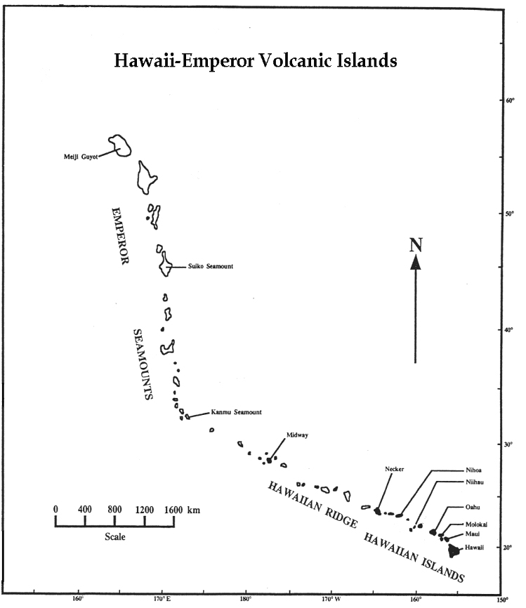
Could the "hole" which produced Hawaii be the result of an ancient impact? Then the Hawaiian Islands, the Hawaiian Ridge and the Emperor Seamounts are just a record of the Pacific plate drifting over that impact site, which is still bubbling...
And if you accept that, what produced the "sudden" left turn in the volcanic chain? Did the Pacific plate go "bump"?
-
Redefinition of Coastthe '60,000 megaton blast' would create 400 foot waves along the east coast
I think in this situation, "coast" is a little irrelevant, as the scale of an area "near" the ocean is not applicable. Eastern side of the North American continent is a better description.
The highest point in Florida is a little under 400 feet, and most is well under that, so that would be hit really hard. Topography of southern Florida. The article says 200 foot wave is the minimum along the East coast...and I don't know if running opposite to the Gulf stream would affect the height.
Not that elsewhere nearby is much safer. Another bad place to be would be the WEST side of the Appalachians where the waves happen to reach over it -- as that flash flood would sweep downhill for another huge distance.
-
A link I forgot to postCheck out this. It goes along with my discussion of catastrophic floods in my other reply to you.
-
Re:Picking from amongst "fairy tales""This has been addressed elsewhere in this
It's been a little while since I've looked at this thread since I've been gone for about three days now, and I don't feel like picking through it again so I'm not sure where the "dupes" as you put them are. However, you can't deny the fact that the presence of reduced iron deposits suggests the atmosphere at the time was *not* oxidizing. It's basic chemistry, and in case the laws of physics have changed since then, chemical reactions worked the same then as they do now.
Now, I don't know where you get your info from on the rates of orogeny and such, but let me cite an example. Currently, the Himalayas are being uplifted at a rate of 1cm per year. This is measurable, so it's cold, hard, can't-get-around-it data. As the page says, in 1 million years, that is 10 *kilometers* worth of uplift. To explain the inevitable question of "why aren't they higher then?", when you account for the weight of such a body of rock depressing the crust and for erosion, that's why they aren't higher.
You speak of the Washington badlands and the Grand Canyon as points of very rapid erosion. You are only right about Washington. The explanation is very straightforward: there was a large glacial lake (Lake Bonneville) much like the current great lakes (but it was much bigger) that basically "broke through the dam" so to speak, releasing it's contents into the Snake and subsequently Columbia rivers. In the case of the Grand Canyon, the Colorado River existed beforehand, and during uplift of the Colorado plateau, the erosion of the river kept pace, eating down through the rocks. Now obviously, you don't believe that this could happen, as I think I argued with out about this before. However, let's think about this logically. *If* all the strata in the Grand Canyon were laid down by a catastrophic flood (throwing out the fact that in such a flood you would have turbulent flow and you couldn't get the vast number of differing rock types in sequence as they are), then why is there an angular unconformity? Did the flood waters decide to stop, wait for a those rocks to be lithified and tilted, then continue on and lay down the rest of the rock layers? If the flood waters were depositing a certain rock type at any one point in time, whey is it not possible to correlate all those formations all across the USA, or even the world? When did the basin and range extension that created the great basin that Lake Bonneville eventually filled cut through these rocks forming the fault blocks that make up the basin? The ancient wave-cut, shore terraces can still be seen in many places in Utah and Nevada...I know because I've seen them. Let me summarize the screwed up order of events you are proposing. 1) Great flood occurs. 1a) Sediments are deposited as a result, Grand Canyon is cut, etc. 2) Faulting cuts these rocks afterwards. In fact a branch of the Hurricane fault intersects the canyon at Lava Falls (basaltic volcanism has been closely associated with these faults). However, the reason there was a basin for a lake to fill up in the first place was the faulting, seeing as there are wave cut terraces within the basins formed by the faulting. There doesn't even have to be an age argument here...we're just talking order of events, right?
Now, I know you posted lots of stuff about different religions, but that's not really my point (not directly anyway). My point is that there is good scientific evidence to support the age of the Earth at 4.6 billion years old. I know you also don't believe in radiometric dating, so it's hard to argue that point. It's like last weekend my fiancee and I had a meeting with her pastor (Missouri Synod Lutheran...yuck) whom is going to marry us in just over a month. I actually got into an argument with him about the age of the Earth, because I felt like he insulte
-
Re:We don't have it here. And we're a quite big...
-
EROS ...
EROS, that's a governmental organization called the Earth Resources Observation System. I actually live near it
http://edcwww.cr.usgs.gov/ -
Re:Ice land
There are a number of sources of geothermal energy on earth. You don't have to be smack-dab on top of a spreading center. Yellowstone is a source of tremendous geothermal energy. The US has (rightly, IMHO) decided that preservation of the unique surface features is more important than mining the heat. If they tried to extract any energy from that system, the geysers would disappear (as has happened at locations in Iceland, for example).
-
Ocean Drilling Program
ODP has been doing research into the area of gas hydrates for a while now. Not only can natural gas be turned into hydrate, but there are vast amounts of gas hydrate "stable" on the sea floor. Gas hydrates are also stable in certains areas of permafrost in the arctic. On an environmental note, it is not known exactly how hydrate. influences global climate change. Methane is 10 times the the global warmer that CO2 is. A large hydrate landslide off the northern coast of norway coincides nicely with an warm period. As sea level falls during an ice age, pressure on hydrates decreases, destabalizing them, and releasing methane into the atmosphere. This could serve as a natural buffer against ice ages. On an interesting side note, Gas hydrates have been proposed as the cause of the dissappearances in the bermuda. triangle. The theory is that a field of gas hydrates destabalizes right below a ship releasing a plume of methane gas. The water density will decrease. The ship sinks.
-
Naming of moonsThose guys are of course free call the moons whatever they want, but the official names are assigned by WGPSN (working group on Planetary System Nomenclature) and finally aproved by the International Astronomical Union's General Assembly.
And they tend to stick to mythology names... Last October 11 Jupiter moons discovered 2-3 years earlier were assigned names from the Greco-Roman mythology.
-
USGS recent earthquake maps
These are maps showing magnitude, fault, date, and so on. You can also view "shakemaps" and other cool stuff.
NEIC real-time list
Los Angeles area seismicity map
U.S. seismicity map
World seismicity map -
USGS recent earthquake maps
These are maps showing magnitude, fault, date, and so on. You can also view "shakemaps" and other cool stuff.
NEIC real-time list
Los Angeles area seismicity map
U.S. seismicity map
World seismicity map -
USGS recent earthquake maps
These are maps showing magnitude, fault, date, and so on. You can also view "shakemaps" and other cool stuff.
NEIC real-time list
Los Angeles area seismicity map
U.S. seismicity map
World seismicity map -
USGS recent earthquake maps
These are maps showing magnitude, fault, date, and so on. You can also view "shakemaps" and other cool stuff.
NEIC real-time list
Los Angeles area seismicity map
U.S. seismicity map
World seismicity map -
Re:As a Civil Eng. graduate..
Who designed the Tacoma Narrows bridge? The Kansas City Hyatt Regency Hotel walkway? The De Havilland Comet 1? The Ocean Ranger oil rig? The L'Ambiance Plaza in Bridgeport, Connecticut? Pre-Challenger solid rocket boosters? Hubble space telescope optics? The Cypress Structure (collapsed in 1989 Loma Prieta eauthquake)?
I knew I should have put a caveat in there
Ok 99.99999% reliable. In most of the cases you mention the reason for failure was encountering a novel method of failure, that hadn't been seen before which is quite rightly the engineers fault for not anticipating it or basic human error which will happen in any situation, but should still be designed against by the good engineer.
Tacoma Narrows bridge - One of first examples of resonance in a large structure caused by wind. Regency hotel Walkway - Predominantly human error in communication coupled with a poor engineering decision Ocean Ranger rig - Engineering design coupled with human incompetance and poor safety routines. DeHavilland Comet- New intensity of cyclic stress strain loading in 1st commercial jet plane.L'ambiance Plaza Generally poor design in a (fairly) new technique.Rocket boostersDesign and checking failure on a massively complex project, obviously pushing the boundries. Hubble optics Not realy in the same catagory, but poor checking procedure, again pushing the envelope.Cypress StructureOver zealous engineers working to code, in an environment they didn't realy understand. Also a relatively novel construction when built.
I know it's not an excuse to say 'we didn't know it worked like that we'll do it better next time'. Compared to the number of structures built the number of failures is very small, engineers have a high level of training to keep it that way. It's a shame that (in the UK at least) we tend to sell our services cheap which doesn't reflect on the importance and responcibilty that we have. When individual code monkeys can get sued for the money a company lost due to there poor code, then they'll make themselves into engineers.
-
Re:Imagine...
Coal is the worst of all: not only does it pollute on a scale normally only seen in nightmares, it even produces more radiation than fission!
Do you have any links on the web to confirm what you are clamming? I never heard of that, and I am skeptic, but hey, I have an open mind...
It's correct but the reason given is spurious. Carbon dating is only good for relatively recent stuff: a million years, tops. The half-life is way too short to get anything from coal deposits. However, coal ash does tend to be radioactive because you collect huge volumes of 'stuff' and reduce it down; a bit like mining for gold. It tends to be trace contaminants, such as Uranium that are the radioactive parts.
US Geological Survey fact sheet -
Re:SGI had a similar globe demo like that...
We did something similar on SGIs for a DoD project about 10 years ago. It was a lot of fun.
-
Re:Not really new...For what it's worth, I read that traffic on CNN was about four times normal that day. Earthquake-driven traffic spikes are about that size overall, but they are very sharp. After the Nisqually earthquake near Seattle [2/28/2001] traffic on the Earthquake Hazards Program web site went up by 300x in 25 minutes. It went from about 2 hits/sec to over 700/sec. I wrote a small article about it at http://bort.gps.caltech.edu/spikes/28feb2001
Bear in mind that the information in there about our server setup is now obsolete. After this event, I calculated that our Squid servers wouldn't be able to handle the load from anything bigger than about M5.5 in either SF or LA, so now we are served through Akamai Edgesuite.
-
Re:How old are they?Your assertion
But given that K-Ar dating is typically used for age ranges in the 10s or 100s of millions of years, these results show that the uncertanty due to primordial argon is small, and hence the method is accurate.
does not agree with sources that believe in K-Ar dating. For example, from here you seePotassium-argon dates usually have comparatively large plus or minus factors--they may be on the order of ¼ million years for a 2 million year old date. In addition, this dating technique usually is of use only where there is rock rich in potassium. Essentially, it is used only where there has been local volcanic activity. Theoretically, however, it can be used for samples that date from the beginning of the earth (4.6 billion years) down to 100,000 years ago or even more recently. (emphasis added)
And from here:Potassium/Argon Dating (K/Ar): Based on the radioactive decay of 40K Age is a function of the 40K/40Ar ratio Application restricted by the formation of potassium Used mainly for dating basalts. Age range 100,000 -> 3,000,000 yrs (emphasis added)
And from here is an even more interesting range:40-Potassium/40-Argon Geochronology - 40-K/39-Ar geochronology is one of the most widely used absolute-dating methods. The method relies on samples rich in mineral grains containing potassium, typically an igneous volcanic rock rich in sanidine feldspar. 40-K undergoes natural radiogenic decay through time (converting to argon-40 at a known rate). As the potassium gradually decays to argon, the naturally inert gas accumulates, confined within the mineral crystal lattice. As a result, the ratio of 40-K to 40-Ar derived from mineral grains is compared with the known rate of radiogenic decay of 40-K. By eliminating possible sources of error, this absolute dating method can be used of on selected rock samples typically ranging in ages from ~10,000 years on back in time to billions of years. The USGS maintains a 40-K/39-Ar laboratory (sample extraction equipment and mass spectrometer) in Menlo Park, CA (emphasis added)
So in conclusion, K-Ar dating is widely accepted for a far younger age than the age supposedly found in the Mt. St. Helens or the other sites.