 Slashdot Mirror
Domain: noaa.gov
Stories and comments across the archive that link to noaa.gov.
Comments · 2,602
-
Re:Month or 30 days?
Generally, no. Usually those who are watching these things happen they measure hundreds of sunspots and then try to do a statistical average over the course of a month to make up the monthly average. Sometimes sunspots are more heavily concentrated on one side of the sun rather than the other, so a monthly statistical average makes much more sense than taking a strictly daily number.
Instead, they are now grasping at straws to even mark off what might even remotely be called a sunspot. That is why this is such a big deal, as reporting the number "0" is often something used to mark off missing data than the actual number observed.
Even if you arbitrarily mark off some other set of 30 days to calculate this figure, this is something to pay attention to.
Here are some daily data sets to compare. First, for 2000:
ftp://ftp.ngdc.noaa.gov/STP/SOLAR_DATA/SUNSPOT_NUMBERS/AMERICAN_NUMBERS/2000
And then for this year (2008):
ftp://ftp.ngdc.noaa.gov/STP/SOLAR_DATA/SUNSPOT_NUMBERS/2008There is a huge difference between these two datasets, and it is remarkable for all of the zeros that are noted in any given day. What is even being called a sunspot is something that is called into question here.
For a whole bunch of historical data, including measurements of sunspots by ancient Chinese historians and data going back several thousand years, see:
http://www.ngdc.noaa.gov/stp/SOLAR/SSN/ssn.html
This includes daily measurements as well as the monthly averages.
-
August numbers in
All, Interesting story but the official numbers are in and there were two days with spots for August (21,22). You can follow all the action at our http://spidr.ngdc.noaa.gov/ website which has SSN back to 1610 (among other indices). No doubt this cycle is unusual in its delayed start though. Regards, Eric
-
Re:Sunspots down... temperature down?
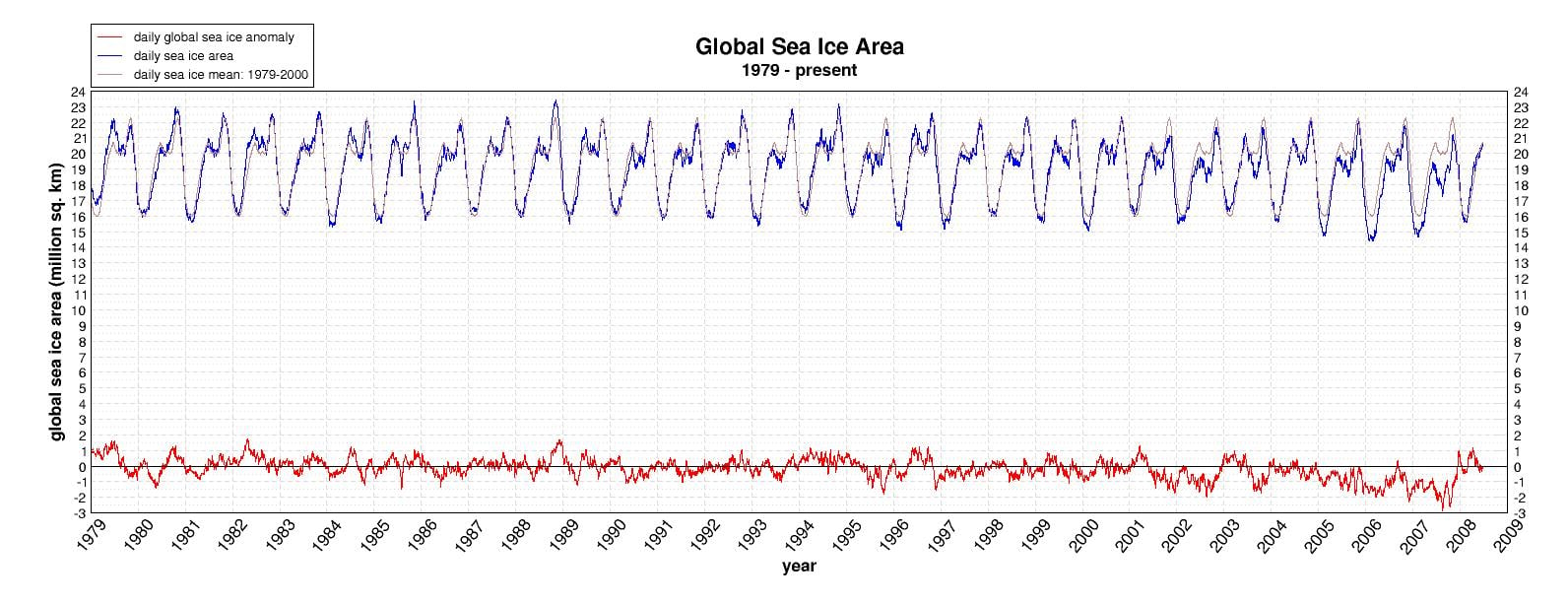
Here's another version of that graph... with additional data. It shows something interesting, I feel.
Up to 94% of Arctic melt is due to dirty snow caused by soot changing it's albedo, rather than CO2 related warming, according the researchers at University of California and a certain Dr. Hansen[PDF warning].
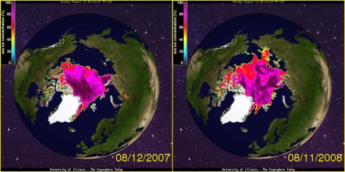
The Antarctic and the Arctic are both up on last years ice, in the case of the Arctic by 10% (according to the NSIDC).
Is it possible that the melting in the Arctic is more to do with other emissions than CO2? After all, the majority of the worlds industry is in the northern hemisphere. I would think it is.
The Northern Passage, by the way, has been navigated at least 100 times since the start of the century, and in 1922 there was open sailing very close to the North Pole [PDF warning]. Submarines regularly surface there, too. 2007 had a shocking decrease in the amount of ice at the pole, definitely. But we cannot be certain WHY.
We should still be tackling pollution, though.
-
Re:The forecasts are powered by Linux
"The National Hurricane Center did an excellent prediction job, just as they did with Katrina."
Hurricane Ivan, not so much.
-
Re:News for nerds huh?
All the Gustav-related nerdiness you could ever wish for over at the Wunderground. Shame the data's not live RSS streaming feeds or somesuch... unless anyone would like to whip up a 'NOLA catastrophe II: this time it's personal" feed? Where's Spider when you need him?
-
Re:This is Andrew, not Katrina
I invite you to have a look at the NOAA's predicted track for Gustav and then tell me it's an over-reaction. It's going to hit New Orleans almost square-on tomorrow morning. The hurricane is not predicted to be as strong as Katrina (Katrina was a very strong Category 5 while Gustav is looking to be about a 3), but it's still a fucking hurricane and it's going to cause damage no matter what. Obviously they're going to make a big deal out of it anyway because Katrina is the best example in recent history of the consequences of being unprepared. You're going to fault them for trying to do better this time?
-
The forecasts are powered by Linux
The National Hurricane Center did an excellent prediction job, just as they did with Katrina. The storm is almost exactly on the predicted track from the last three days. It's all done on Linux. The forecaster's desktops run Red Hat Linux. The back end systems run Linux. The supercomputing clusters run Linux.
-
Re:News for nerds huh?
Uh, it's not the USGS, it's NOAA.
Please turn in your nerd card immediately.
-
Re:Seriously : No
This is indeed one of the presumptions of the "global warming" crowd, that the solar flux (aka the "radiation" including heat, light, and other forms) from the sun is constant over human lifetimes.
By far and away most stars that can be observed have some sort of variation over time, and I don't believe Sol to be the exception here either. Indeed, the thermal mass of the Sun's mid-layers between the core and the "surface" would seem to be a moderating influence to variations in nuclear reactions, and even a modest oscillation in the density of the solar core could have some profound variations in nuclear reaction rates.
As for historical records of solar activity, there are records of sunspots going back hundreds of years, and there have indeed been periods of nearly zero sunspots at all.... with a correlation between this sunspot minimum and global temperatures. For some hard data including information that is fairly current, you can see the raw numbers at:
http://www.ngdc.noaa.gov/stp/SOLAR/SSN/ssn.html
Since neutrino detection is something rather new to science, there really aren't direct historical records to compare this sort of information to what may or may not be happening in the past. "We don't know" is a better answer than trying to take a shot in the dark about what may or may not be the case in terms of what is happening inside of the Sun.
-
Steve.....Steve....Steve...Steve...Steve...Steve...calm down, please. Put that chair down. Ok? It's a nice rainy day here, it's a beautiful campus, and we're THE rulers of the World. No problemo.
I know, I know, Stallman has the "moral high ground", a full head of hair, and everything, but what does it matter? You're filthy rich and he's a peasant selling GNU toys and t-shirts on the internet.
It's OK. Shhhh, sshhhh, it's OK...sh......
Lullaby, Lullaby, Lullaby,...shhh...
-
Population Density
Interestingly, all of these states are densely populated.
Exactly! If you google a space photo of the night-time side of the US, you will see that the east coast is populated much more densely than the west. Companies get more per infrastructure investment in densely populated areas. There's more potential customers per box or node.
-
Scientific Conclusions
No particular individual dataset of observations definitively 'proves' the correlation of human caused climate change. But the cross correlations between an incredibly diverse set of observations does provide a basis for a pretty well based assumption. These include ice cap bores from Greenland, species in seabed sediments, coral growth, tree rings (even petrified trees
What hobbles this in every case is the sample space, what is needed a fine resolution chronographic continuous globally distributed climate record. I.e. the ice caps are only located in certain areas and so it has only been in the last few years we have had satellite platforms to global measure sea temperatures. Global weather monitoring on a regular basis only started during World War Two, mostly driven by military aviation.
If Climatology is a tough nut, Paleoclimatology is even tougher. Ironically, the world wide exploration for oil combined with temperature as an indicator for petroleum formation has provided one possible set of observations. See " Optimal Surface Temperature Reconstructions Using Terrestrial Borehole Data" (and others) at http://www.ncdc.noaa.gov/paleo/pubs/mann2003/mann2003.html This area of current relies on ancillary data, but could be extended to deeper wells and better distributed locations to increase the time horizons.
The diverse and broad studies around climate change complement and supplement one another to reach the conclusion and correlation. Sunspots and lemming migrations can be argued endlessly, but it is the meta analysis of all these efforts that matters. If the media has a hard time with translating and portraying the problem and controversy inside a particular specialized scientific study, it is absolutely incapable of informing the public about the meta analysis. So drowning cute polar bears isn't scientifically precise, if the imagery causes behavior change, all the better.
The other aspect of the debate is the time dynamics and values of the risk situation: What is the cost of doing business as usual in the event the warming hypothesis is wrong? If we mitigate the carbon impacts and it's wrong, so what? We have a vastly more efficient and clean economy. If it's right, the downside is potentially death and disruption for billions. Also, how long do we have to figure it out?
-
Re:gore
I'm not going to doubt what you have put up, but I want to add to it. But as early as 10 am Saturday, NOAA had issued specific hurricane warnings that said
"AT 10 AM CDT...1500Z...A HURRICANE WATCH IS IN EFFECT FOR THE
SOUTHEASTERN COAST OF LOUISIANA EAST OF MORGAN CITY TO THE MOUTH OF
THE PEARL RIVER...INCLUDING METROPOLITAN NEW ORLEANS AND LAKE
PONCHARTRAIN. A HURRICANE WATCH MEANS THAT HURRICANE CONDITIONS
ARE POSSIBLE WITHIN THE WATCH AREA...GENERALLY WITHIN 36 HOURS."At 7 PM, NOAA was advising 12 foot waves already reported along the coasts and that a watch would turn into a warning later that night.
At 10 PM Saturday, NOAA reported storm surged of 10-15 feet above normal tide levels along with waves reaching 25 feet or more. This is in the first link I presented about Saturday. In case you would like to stroll through the adviseries yourself, here is a link to the archives.
At 1 am Sunday, Katrina was a category 4 hurricane and was now a watch instead of a warning
"HURRICANE KATRINA SPECIAL ADVISORY NUMBER 20
NWS TPC/NATIONAL HURRICANE CENTER MIAMI FL
1 AM CDT SUN AUG 28 2005A HURRICANE WARNING IS IN EFFECT FOR THE NORTH CENTRAL GULF COAST
FROM MORGAN CITY LOUISIANA EASTWARD TO THE ALABAMA/FLORIDA
BORDER...INCLUDING THE CITY OF NEW ORLEANS AND LAKE PONTCHARTRAIN.
A HURRICANE WARNING MEANS THAT HURRICANE CONDITIONS ARE EXPECTED
WITHIN THE WARNING AREA WITHIN THE NEXT 24 HOURS. PREPARATIONS TO
PROTECT LIFE AND PROPERTY SHOULD BE RUSHED TO COMPLETION."Now, for you normal people sleeping at home, unless you were up and caught this, my point isn't all that valid. But for the mayors and governors and any other government office, this is important stuff that is needed to get the ball rolling on disaster plans and evacuation plans. I don't fault the people, I fault the local governments.
At 4 am Sunday, NOAA had this to say
"...DANGEROUS CATEGORY FOUR HURRICANE KATRINA CONTINUES
WEST-NORTHWESTWARD BUT EXPECTED TO TURN NORTHWARD...A HURRICANE WARNING IS IN EFFECT FOR THE NORTH CENTRAL GULF COAST
FROM MORGAN CITY LOUISIANA EASTWARD TO THE ALABAMA/FLORIDA
BORDER...INCLUDING THE CITY OF NEW ORLEANS AND LAKE PONTCHARTRAIN.
A HURRICANE WARNING MEANS THAT HURRICANE CONDITIONS ARE EXPECTED
WITHIN THE WARNING AREA WITHIN THE NEXT 24 HOURS. PREPARATIONS TO
PROTECT LIFE AND PROPERTY SHOULD BE RUSHED TO COMPLETION."If that didn't get someone out of bed and doing something this next one should have.
At 7 am Sunday, a day before the storm hit, NOAA issued this report
"...KATRINA...NOW A POTENTIALLY CATASTROPHIC CATEGORY FIVE
HURRICANE...HEADED FOR THE NORTHERN GULF COAST...A HURRICANE WARNING IS IN EFFECT FOR THE NORTH CENTRAL GULF COAST
FROM MORGAN CITY LOUISIANA EASTWARD TO THE ALABAMA/FLORIDA
BORDER...INCLUDING THE CITY OF NEW ORLEANS AND LAKE PONTCHARTRAIN.
A HURRICANE WARNING MEANS THAT HURRICANE CONDITIONS ARE EXPECTED
WITHIN THE WARNING AREA WITHIN THE NEXT 24 HOURS. PREPARATIONS TO
PROTECT LIFE AND PROPERTY SHOULD BE RUSHED TO COMPLETION."The city failed to act. The governor issues a mandatory evacuation by this time and nothing substantial was done. People who watched the news and could do something did. Those who couldn't were let down by the very people claiming they would be safe. Between 6 am and 8 pm, Katrina stated pounding and making landfall
-
Re:gore
In case anyone doubts your recollection here's the actual prediction from that Saturday morning... http://www.nhc.noaa.gov/archive/2005/prb/al122005.prblty.017.shtml?
On Saturday morning there was a 20% chance of the hurricane passing near NO, but it really could have struck land anywhere between Tampa and Corpus Christi at that point.
It really wasn't until Sunday that it became likely it was heading for NO and even then it was just a 1 in 3 chance. http://www.nhc.noaa.gov/archive/2005/prb/al122005.prblty.023.shtml -
Re:Besides...
Unlikely to be sunspots. We're currently at the very bottom of the solar cycle.
-
Beijing as seen by a meteorologistI am a meteorologist. I'm not going to dispute this particular Chinese claim, but I think it needs to be taken in context because the Chinese have not been above stretching the facts when it serves them.
The weather and air quality have been fairly close to the worrisome scenario painted months ago. I've been checking meteorological observations every day, finding the dew point at Beijing's airport in the mid and upper 70s on a regular basis and visibility of 1-2 miles common (It is currently under 1 mile, but there is rain falling).
Back in February I wrote on my blog of the potential Olympic weather: "So, when the deputy chief engineer of the Beijing Meteorological Bureau says, "Even if the rare extreme weather hits Beijing in August, people will not feel muggy. High humidity will not accompany the hot weather in August because their climax periods are different, " I'd hide the silverware and other valuables."
Current Beijing observations are here.
Dew points (the real number you should look at when you think humidity) have been consistently in the 70s--often the upper 70s. That's like walking around with a warm, damp cloth wrapped around your body. Much of yesterday had Beijing more humid than Miami.
I would feel better about what the Chinese say if dissenting voices were allowed to speak about the air!
There is an independent group from Cambridge Environmental Research Consultants in England who have been monitoring the air and issuing their own forecasts which have been much more pessimistic than the official government version. Now that forecast is gone! From Telegraph.co.uk: British scientists monitoring air quality in Beijing have been ordered to close down their website after their readings clashed with official statistics showing the city was meeting its pollution targets.
-
Re:Oh dear
First thing I thought of was METAR.
-
Re:At what point does ythis break down?
Is the earth warming? Yes. Definitive proof: National Oceanic and Atmospheric Administration data
Note that the value of "0" on those charts was arbitrarily set as the mean value of the temperatures from 1961 to 1990. However, it is very easy to see that across the globe, from 1845 to now the average temperature has risen about 1 degree C. That is an important amount. Especially considering that the difference in many places of 1 degree C is the difference between having ice in winter and not.
We in the Northwestern hemisphere have experienced 7 of the top 8 warmest years on record since 2001, and all 10 top warmest years since 1995. That says something right there. The difference between daily high and daily low temperatures has been decreasing as well over about 65-75% of all land masses. And the trend of both the high and low has been moving higher over the last 2 decades. In other words not only are we seeing higher high temperatures, we are also seeing higher low temperatures, and the low temperatures are growing higher faster than the high temperature is growing, meaning there is less and less capacity of cooling occurring, and possibly a thermal limit has been reached (kind of like how once you exceed the capacity of an air conditioner it doesn't matter how high you turn on the fan or low you set the temperature, it still is going up because it can't cool the air fast enough). The amount of sea ice has decreased 23% in just the last year alone. There is also been a trend across the globe of fewer low temperature records.
With the current trends in temperatures, in 2100, the global temperature will be around 5 degree's C warmer than in 1840's (when we started keeping regular weather records).
Now, given the FACT that it is getting warmer, I would say that we have a Global Warming Problem. Now, know that fact, we need to look at ways which we know contribute and play a part in warming an ecosystem and the environment. We know that greenhouse gases trap extra heat in the environment. That has been proven in many studies and papers. So we know it can contribute to warming. So step one, start decreasing the production of greenhouse gases will help reduce the effects of Global warming. Now, will it be enough? We don't know, but it is something that we can control. There are other factors that we can not control (i.e. we don't know how to control the energy output from the Sun... so that is not something we can do, and thus, it is really a moot point). -
Re:Hot Vents Melt ICE? Noooooooo! It couldn't be!
Vent and Seep Communities on the Arctic Seafloor
http://www.arctic.noaa.gov/essay_vogt.htmlBoiling Hot Water Found in Frigid Arctic Sea
http://www.livescience.com/environment/080724-black-smokers.html"Many miles inside the Arctic Circle, scientists have found elusive vents of scalding liquid rising out of the seafloor at temperatures that are more than twice the boiling point of water."
"The cluster of five hydrothermal vents, also called black smokers, were discovered farther north than any others previously identified. The vents, one of which towers four stories high, are located on the Mid-Atlantic Ridge between Greenland and Norway, more than 120 miles farther north than other known vents."
-
Re:Who's really being self obsessed?
You wouldn't be republican by any chance ? The whole "Why should we subsidize intellectual curiosity?" thing ?
I you admit the principle of public funding for science, then I think every areas should deserve equal support. There is no reason why we should support paleontology, particle physics, genetics, etc... but not space science.
As for your argument on low return, I think it is misguided. You can't put everything in the same basket. Most of the money has been spent on human spaceflight which IMHO has teached us nothing and hasn't gotten us any closer to the goal of affordable space travel.
I don't known what the total budget for unmanned scientific missions is, but it is not that big and the return has been enormous.
Take solar system exploration. Practically all our knowledge about the solar system comes from space probes. Just look at the wikipedia pages on the planets and major moons. Most of the information there comes from space probes.
Or take astronomy. Chandra, Compton and Spitzer revolutionized our understanding of the universe.
As for the practical usefulness, I find your comment funny because I don't think paleontology (on earth), which you don't seem to object too, has much practical applications.
Of course, I don't think we should only fund research that has a potential for practical applications, but that's another debate.
Anyway, I do think solar system research has a lot of practical uses. Mostly because a better understanding of the solar system leads to a better understanding of the earth. The problem with understanding the Earth is that there is only one. You can learn a lot if you have the opportunity to compare it with similar yet different bodies. Studying the climate of Venus for example will help us better understand Earth's climate. Just like studying the hydrocarbon cycle of Titan, the volcanism of Io, or the interaction of Mars's atmosphere with the solar wind will yield new insights.
Oh, about the ocean thing. I don't know where this myth comes from but oceanography is far from underfunded. Look at what NOAA or Scripps is doing. They have pretty solid research programs.
-
Re:Bloody Brilliant IdeaIMHO the lawyers who brought the lawsuit have done even a better PR job. Their version of the "facts" is the #1 hit on Google.
- They conveniently omit that the coffee was stored and served at the temperature recommended by the National Coffee Association and is also the default temperature setting used by the largest manufacturer of commercial coffee making machines (scroll down to the bottom).
- Their suggestion that coffee should be served at 135-140 F contradicts recommendations by coffee connoisseurs and the industry (Bunn recomments 155-175 F at serving).
- Dunkin Donuts and Starbucks served coffee at the same temperature as McDonalds. The lawyers used slick wording to mislead people into thinking the lowest temperature in a survey was the standard coffee serving temperature.
- Contrary to your claims, the cups were safe. There were 700 complaints about hot coffee in a decade, but that was across billions of cups served. It works out to a complaint rate of 1 in 24 million. For comparison, the rate of being hit by lighting in the U.S. is 1 in 600,000. The mortality rate in the U.S. from motor vehicles (PDF warning) was 1 in 6580 in 2002. She was 6500x more likely to die from riding in a car than being burned by the coffee. Are cars an unsafe product?
- If you read the court documents, you'll see the lawyers concentrated on the severity of the woman's burns, not the circumstances that led to those burns. This was an appeal to emotion, not a dissemination of facts. Anyone who's boiled water has handled (presumably safely) a substance capable of much more severe burns.
Read the case as told by the lawyers who brought the suit. Then read an alternate viewpoint. Then decide for yourself which side is more in line with the facts.
-
Re:Pshaw
he said he lives in the midwest. I don't see ice being THAT big of a problem there.
Your comment displays either a serious lack of knowledge about USian geography and the weather thereof or an addiction to heavy drugs. Assuming it's the first, let me inform you:
What is generally called "the midwest" in the US extends from essentially Canada in the north down to Kansas or Nebraska in the south (eh, and maybe Missouri, but that's stretching, in my mind), and from the Dakotas in the west to Ohio in the east. One interesting nugget of information here is that at least some of the midwest is north of New York.
It's a pretty broad span of land, and so the weather isn't really consistent across it, but it gets pretty darn icy across at least Illinois, Iowa, and Nebraska in the winter. This is speaking from personal experience. I'm sure that if you wanted to do a little bit of data mining (at NOAA, for example), you could find data backing my statement up. Or you could go watch Fargo, which is set in Minnesota (which is part of the midwest). That's a pretty icy movie.
-
Re:Did nobody read the actual text of the act?
I'm looking at "15 CFR 960 Licensing of Private Land Remote-Sensing Systems; Final Rule", dated April 25, 2006. The link to it in PDF format was from here.
-
call NOAA for more info
I suggest we call and get more info, according to this:
"If you think this may apply to your team, NOAA strongly encourages you to contact
us for a non-binding consultation at:
Email: noaa.crsl@noaa.gov
Phone: 301-713-2024 ext 213/202" -
Did they get an NOAA license for this?
The NOAA takes its licensing claims very seriously. It's far more lucrative that ocean and atmosphears stuff. No. paperwork is where the real future lies. http://www.licensing.noaa.gov/
-
Notice from NOAA to Lunar X Prize Participants
Here's the letter from NOAA to the Lunar X participants that outlines how this is pursuent to the Land Remote Sensing Policy Act of 1992 - says it may take up to 120 days to obtain the license - think about that before you take your first picure!
In the meantime, you can use existing satellite photos to image your house and here's a cool way to get a nifty Earth view. -
Re:Impossible nonsense
Because that's was climatologists think.
Or after further reading that's what they...thought. Oops.
Of course I am not a climatologist. Since you apparently are one, I must ask: Why are you saying that in 2012 "things are going to get a bit nippy"?
-
Re:You know who I feel sorry for?
>there is no massive coastal flooding already taking place
Which doesn't disprove the climate models. IPCC estimates are for a sea level rise of 110 to 770 mm by 2100.
>the fact that the middle ages saw hotter weather than we are seeing now
Only in the North Atlantic area. The global average was lower:
Raymond S. Bradley, Malcolm K. Hughes, Henry F. Diaz (2003). "Climate in Medieval Time". Science 302 (5644): 404-405>the Sun has caused these fluctuations before, is now, and will likely do so again.
Compare the temperature trend over the last thirty years to the direct satellite measurements of solar irradiance at the Earth's orbit.
-
Watch the ice melt
On the North Pole web cam.
-
emission spectrumWhere has the Bush Administration denied the greenhouse effect warms the side of the Earth which isn't facing the Sun?
Oh, you meant they refuse to formally acknowledge U.S. human activity somehow controls the greenhouse effect. That's very different. What do you mean, "somehow"? Did you fail high school chemistry or just skip science education altogether? -
Re:The Bucky Ball Globe
Here's one, courtesy of the NOAA: http://www.ngdc.noaa.gov/mgg/image/dodecahedron.pdf.
-
Super Resolution / RPG Build 10
This year, the NWS has started the installation of RPG Build 10. This, which also requires an upgrade of the network at the forecast office--will increase the resolution of the WSR-88Ds enough to essentially double the range.
Upgrade status: NWS Level II Radar Recieve Status
03 - Build 10 installed & the network updated to provide the LDM veed.
04 - Build 10 installed, but lacking the network upgrade. Data is derived to fit the legacy Level-II bandwidth.
NULL - Still Build 9, and no status of the network upgrade.
Reflectivity products will go from 1km bins x 360 radials to 250m bins x 720 radials. Velocity products will go from 250m bins x 360 radials to 250m bins x 720 radials. Range is increased to 300nm.
Common users will not see an improvement with the upgrade, unless they get a NEXRAD Level-II data feed. What you see on TV and the Internet are based on Level-III (more products, but much less resolution.)
Legacy Level-II to Level-III comparison: There are 4-bits resolution on Level-III products, whereas Level-II has 8-bits. Level-III doppler products are limited to 1km bins x 360 radials. (Build 11--next year--though maybe not publicly available, will introduce 5 new dual-polarization products, some having 16-bit resolution.)
The WSR-88D's still have quite a bit of life left in them... Granted, more nodes that have doppler products would be a big plus. But Super Resolution L-II data will give a big improvement. -
Re:Summary wrong in pretty much every claim
PAR systems have a bonus that CASA does not have: Active target tracking and targeting. You see, the SPY-1D system that is set up at NSSL Norman was pulled off of one of the Aegis nuclear-powered cruisers. Several advantages include graceful degradation. If something breaks on the panel, the system can adjust automatically to compensate, preventing an outage from knocking the unit out in case of a Major Event. One part breaks on the 99D's, game over until a tech gets out there to fix it. Another is no or few moving parts. PAR units are static, using electronic wizardry to steer the beam to the intended target. The other biggie is replacement or supplement for the ATC system. PAR's sensitivity and brute force have tracked targets at nearly over the horizon (OTH) range. That leads up the big item: cost savings on all fronts that need radar. Multitasking the beam can eliminate redundant installations, dramatically carving chunks off of budgets that can be used elsewhere.
NEXRAD's are aged, old units, and NOAA knows it. The klystron transmitter modules have been replaced more than once in the shacks and the rest of the hardware probably replaced or repaired several times over.
Even the military is looking into it.
http://www.roc.noaa.gov/eng/docs/Solid_State/Solid_State_Transmitter_PIWG_Brief.pdf -
Summary wrong in pretty much every claim
The summary statement gets things wrong in pretty much every respect, so this is mainly for those folks who read the summary and assume it's a fair reflection of the story.
(1) CASA is not designed to replace the existing NEXRAD network. It is designed to supplement it. NEXRADs are designed for long-range surveillance. CASA radars see "under" the NEXRAD umbrella, up to 3km in height. The article makes this clear.
(2) NEXRAD scans are not slow. The fastest volume coverage patterns (VCPs) in NEXRAD, used in severe weather, scan the atmosphere every 4 minutes. The only thing faster is phased array radar and it is still experimental (See: http://www.oar.noaa.gov/spotlite/). CASA radars don't have volume scans, but their antennas are about the same speed as NEXRAD's.
(3) NEXRAD is not limited in range. It goes up to 460 km. A CASA radar's range is only 30 km. If any one thinks that NEXRAD is "deeply flawed" due to its limited range, they need to take it up with the Flat Earth Society (the range limitation is mostly because of the earth's curvature).
Please make sure you understand an article before sending it off to Slashdot! -
Re:SlowIs a faster system going to improve the generally rubbish weather forecasts of "it might rain today" No, nothing can help that. It's really tea-leaf reading.
What a faster system with a finer resolution will do is help better tell if that big nasty storm moving into your part of town will be an F1, or an F5 Magic Eraser.
It also will help stretch the warning leadtime. It's still not good enough.
Nexrad took the warning from pretty much after-the-fact to about +15 minutes these days. Nexrad, compared to the old-school FPS-77 and the like, is pixie dust.
The real clincher, not mentioned in TFA?
They're working on a phased-array replacement for Nexrad. Hit multiple individual cells at once. http://www.nssl.noaa.gov/research/radar/par.php -
Outdated information
From the article...
Under the current NEXRAD Doppler system, a warning could be statewide, leading to false alarms for most of its residents.
No, not so much. The National Weather Service has started issuing storm-based (polygon-area based) warnings since August 2007. Prior to that, they were county-based warnings, which were a problem (Cook County, IL being about 50 miles tall by 40 miles wide, while average tornado widths are about 100 yards) but nowhere near the "statewide warning" the article claims.
Awful FAQ here: http://www.nws.noaa.gov/sbwarnings/FAQ/engage.html
-
Sun Spot Cycle Normal
The new cycle started back in February and is proceeding normally. http://www.swpc.noaa.gov/SolarCycle/
You can view current solar activity here and there is at least one spot. http://umbra.nascom.nasa.gov/images/latest.html -
Re:solar warming, that's why.
Why use temperature trends on Jupiter as a source when there are multiple overlapping direct exoatmospheric measurements of solar irradiance?
Why not use a direct measurement of what you're interested in? And check for yourself how well it does or doesn't correlate with the same time period in the temperature record?
Why distract people from the best data? -
Giving a break to satellites - or not
Of course, the big coronal mass ejections which are associated with very intense ionizing particle fluxes at satellite level are not encountered in solar minimum.
However, the trapped proton fluxes of the Van Allen belts, mainly present in low earth orbit and medium earth orbit (roughly from 500 km to 18000 km) show an inverse dependance to the solar activity: they are more intense in solar minimum. In solar maximum, the atmosphere is heated up and expands, causing more trapped protons to decay. The increase in solar activity is also correlated with a decrease of cosmic rays coming from outer space, which are important contributors to the trapped neutrons belts.
For satellites in geosynchronous orbits which are mainly crossing electrons belts, it's the reverse story, though.
To get back on the topic, here are the current solar cycle predictions. -
Where are the numbers from?
In the past, solar physicists observed that the sun once went 50 years without producing sunspots, coinciding with a little ice age on Earth that lasted from 1650 to 1700."
This is really really *really* hard to say. Our data on sunspots in prior to about 1750 is pretty dismal. Most of the mentions of sunspots are casual or even accidental observation. You can find a lot of data on this at the NOAA ftp site:
Reports of sunspots from 164BC to 1918AD
Monthly average of sunsports from 1749 to present
Note two things: One, that there were reports of sunspots between 1650 and 1700; two, that the data prior to 1749 is inaccurate and (pardon the pun) spotty.
Note that the monthly averages file (the second one) is fairly accurate, as the older data in that file was made by the Royal Observatory and the later data in that file was made by the NOAA. I find it really hard to jump to the conclusion that the little ice age was a result of sunspots. Without a time machine, I don't think we could say that with any degree of certainty. -
Re:solar warming, that's why.
Try 12,000 years.
I'm sure it has nothing to do with the incredibly rapid 2.5C temp increase in the last 50 years.
Nay, my good man, all is well. Continue whistling and dance that little jig you do so well. -
Re:1st Law of ThermodynamicsHow much energy would these farms be pulling out of the wind? How would that impact weather patterns? The phrase "drop in the bucket" comes to mind. The estimated wind-power output of a hurricane has been estimated at 1.5e12 Watts, or about half the world-wide electrical generating capacity. Even if we get a substantial amount of energy from wind, we'll probably have less of an effect on the climate than a hurricane does.
-
Re:Here's a better idea... More alternatives:
To steer the topic back to technical rather than emotional content, here More related links:
Probably one of the more interesting ideas:
Ballast-Free Ship to Combat Aquatic Life
http://michigantoday.umich.edu/2008/apr/ballast.php
And others:
http://massbay.mit.edu/resources/pdf/NABSdatasheet.pdf
Using pier-side bottles to collect ship ballast water
http://www.seagrant.noaa.gov/newsevents/stories/Ballast_water_battles.html
UV Disinfection Method
http://www.triangularwave.com/a3b.htm -
It's not my money
I'm an Aussie and just qualify as a baby boomer (1959), the moon-landing grabbed peoples attention the world over in the opposite way to 911 (except the Eastern bloc), every kid wanted to be an astronaught. Problem now is "it's been done" and ICBM's that can hit a gnat between the eyes from 12,000 miles away are "ho-hum".
I'm glad I was paying attention as a 10yro at that point in history but now I'm older I appreciate NASA for the "Great Observatories" project, of which Hubble was part. I also appreciate their landsat type missions and the interplanetary probes they send out every now and then, and to give the military side of things credit where it's due - let's not forget GPS.
From what I read, the current occupants of the Whitehouse have gutted these budgets in favour of the man on Mars "pipe dream". I get the idea that the "dream" was to hinder the flow of acurate environmental data concerning our own planet, or perhaps it's just a personal vendetta against a man who stubbornly speaks truth to power. Whatever it is, it's not motivated by a GWB Duck Dogers fantasy, nor does it appeal to this particular baby-boomer/flower-child.
They could declare the cold war over and let the space station die a natural death. The only role left for humans is the space shuttle missions, either they could design robots to replace them in these tasks (and spur a bit of tech), or maybe save all that shuttle infrastructure money and simply claim dud missions on insurance and send up a replacement observatory/probe instead of a repair crew.
I sympathise with the "put-up or privatise" argument but I fear the put-up option is a white elephant, and the privatise option would just create an orbiting Disneyland that will be created by the private market sooner or later anyway. From my POV I think politicians should provide stable policy and budget, scientific merit should provide the projects.
Anyway, thanks for over 40yrs of free food for my sense of awe at the universe. From my POV NASA's non-military arm really is one of modern man's greatest scientific institutions, akin to the great library of Alexandria in it's time. It would be a shame to throw the baby out with the bathwater but at the end of the day, it's your baby.